10 Great Trails in Parks Most People Skip
Ten trails in overlooked parks where solitude and wilderness character matter more than guardrails and crowds
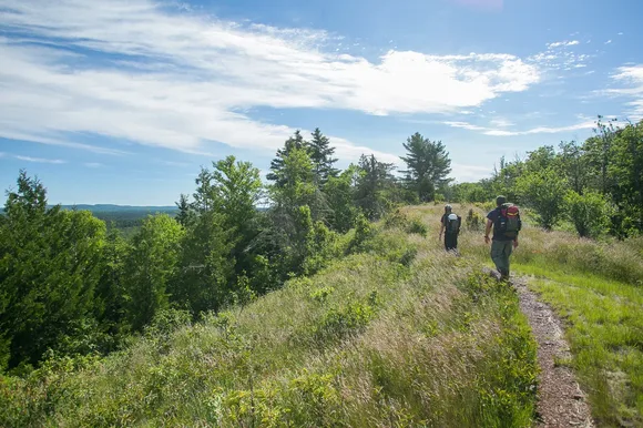
Most visitors aim for Yellowstone, Yosemite, and the Grand Canyon. They follow the crowds to overlooks with guardrails and trails that feel more like paved concourses than wilderness routes. But the national park system includes over 400 units, and the ones that draw the smallest crowds often deliver the biggest rewards — if you're willing to work for them.
These ten trails represent the opposite end of the spectrum. Some sit in parks that see fewer visitors in a year than Zion does in a weekend. Others hide in plain sight within moderately visited parks, overlooked because they demand real backcountry skills. What they share is a promise: if you can handle the logistics, the remoteness, and the lack of infrastructure, you'll have these places almost entirely to yourself.
Off-Trail Backpacking, Gates of the Arctic
No distance, no trail, no infrastructure / Navigate by topo map through the Brooks Range
Gates of the Arctic is the only national park in the system with zero maintained trails. Not poorly maintained, not occasionally brushed out — zero. You're navigating by topographic map and compass through caribou habitat above the Arctic Circle, where the nearest road ends a hundred miles south and the nearest cell tower might as well be on Mars. This is wilderness in the truest sense: no bridges, no cairns, no signs pointing you toward anything.
You choose your own route through tundra and river valleys, and the only footprints you'll find are from grizzlies and wolves.
Most people charter a bush plane from Bettles or Coldfoot, land on a gravel bar, and spend a week walking through country that looks exactly as it did ten thousand years ago. Late June through mid-August offers the longest daylight and the warmest temperatures, though warmest here means you'll still wake to near-freezing nights. This is not a park for beginners. It's for people who understand that true remoteness comes with real consequences.
River Paddling, Gates of the Arctic
Multi-day expeditions down Arctic rivers / Bush plane drop-off, no put-in signs, no shuttle back
If off-trail hiking feels too unstructured, river paddling in Gates of the Arctic offers a slightly more defined route — the river chooses the path, you just follow it. Bush planes drop you and your packraft or canoe on a gravel bar along the North Fork Koyukuk, Alatna, John, or Tinayguk, and you spend the next week paddling through country where the only signs of human presence are the occasional hunting cabin or mineral claim from decades past.
There are no rental kiosks, no shuttle buses, and no fellow paddlers waving from downstream — just you, the river, and a landscape that swallows you whole.
Late June through mid-August offers the best water levels and nearly 24 hours of daylight, with mid-July hitting the sweet spot before rivers start dropping. You'll need to know how to read water, manage a loaded boat through Class II rapids, and set up bear-proof camps on gravel bars. The wildlife encounters are extraordinary — caribou crossing the river, wolves on the banks, gyrfalcons overhead — but they're not curated experiences. They're just what happens when you paddle through one of the least-visited parks in the system.
Minong Ridge Trail, Section 4: North Desor to Windigo, Isle Royale
Thirteen miles of primitively maintained wilderness / Navigation skills required, crowds nonexistent
The Minong Ridge Trail runs the length of Isle Royale's northern spine, and this final section is the trail at its most uncompromising. You'll push through the charred aftermath of old wildfires where new growth fights through blackened trunks, then descend into dense boreal forest before finally dropping into Windigo. The footing is relentless — roots, rocks, mud, and stretches where the trail nearly disappears under vegetation.
This is the kind of trail that makes you work for every mile, where looking up from your feet to check the map feels like a small luxury.
Most backpackers on Isle Royale stick to the Greenstone Ridge or the coastal trails, where the tread is clearer and the company more frequent. The Minong rewards solitude seekers and wilderness purists willing to trade easy walking for empty campsites and unobstructed ridgeline views. Mid-July through late August offers the driest conditions and longest daylight, both of which you'll need. This section will take longer than the mileage suggests.
Feldtmann Loop, Section 2: Feldtmann Lake to Siskiwit Bay, Isle Royale
A full day of backcountry travel through Isle Royale's wild heart / Ridge walking with sweeping views
This is the section of the Feldtmann Loop that separates casual backpackers from committed ones. You'll climb steeply from Feldtmann Lake up to the spine of Feldtmann Ridge, where the boreal forest opens up to sweeping views of the lake below and the ridges rolling toward Lake Superior. The trail follows the ridge for miles before dropping down through thick forest toward Siskiwit Bay, gaining and losing elevation in a way that feels less like hiking and more like negotiating with the landscape.
The ridge walking is some of the finest on the island — exposed rock, endless views, and the kind of silence that makes you forget other people exist.
Late July through mid-August offers the driest footing and the longest daylight, which matters when you're covering this much ground with a full pack. The descent into Siskiwit Bay is steep and technical in spots, and by the time you reach camp, you'll have earned every ounce of that freeze-dried dinner. Most people skip this loop entirely in favor of the more popular Greenstone Ridge traverse, which means you'll likely have Feldtmann Ridge to yourself.
Feldtmann Loop, Section 1: Windigo to Feldtmann Lake, Isle Royale
The opening act of one of the most remote loops in the Lower 48 / Dense forest and rocky footing
This is not a casual day hike. From Windigo, the Feldtmann Lake Trail pushes through dense boreal forest where the vegetation crowds the path like it's trying to reclaim the corridor. Expect roots and rocks underfoot, occasional mud bogs, and the kind of slow going that makes you grateful for trekking poles. The trail eventually opens up near Feldtmann Lake, where the campground sits on the shore and the world feels about as far from civilization as you can get without leaving the Lower 48.
By the time you reach the lake, you'll understand why so few people commit to this loop — it's beautiful, yes, but it demands your full attention from the first mile.
Mid-July through late August offers the warmest weather and longest days, though late August and early September bring fewer mosquitoes and thinner crowds. The bugs are no joke earlier in the season — head nets and long sleeves are non-negotiable if you're hiking in July. Wildlife sightings are common, especially moose near the marshy areas, and the solitude is nearly guaranteed. You won't see day hikers this far from Windigo.
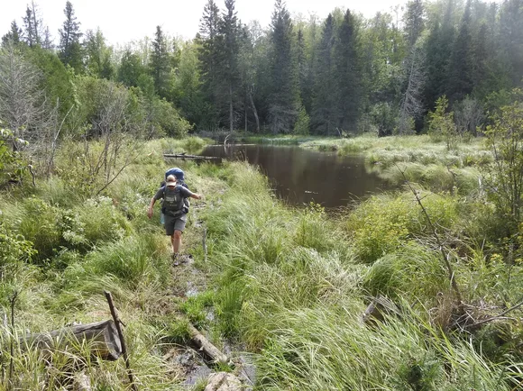
Huginnin Loop, Isle Royale
Eight miles of isolated shoreline and boreal forest / Starting from Windigo, ending at the same trailhead
Starting from the Windigo visitor area on Isle Royale's remote west end, the Huginnin Loop drops you into one of the most isolated day hikes in the Lower 48. The trail threads through boreal forest thick with spruce and birch before spitting you out onto the rocky northern shoreline of Lake Superior. You'll walk the coast for miles, hopping between cobblestone beaches and granite shelves, before looping back through forest to Windigo.
The shoreline walking is as close to wilderness beach-combing as you'll find in a national park — no footprints, no boats, just the sound of waves on rock.
Mid-July through August offers the warmest weather and longest days, with wildflowers peaking and Lake Superior calm enough to appreciate the shoreline without getting soaked by spray. History buffs will find remnants of old mining operations and fishing camps scattered along the route, quiet reminders that this island has always attracted people willing to work for isolation. The loop is rated easy, but that's relative — the footing is rocky, the distance adds up, and you're far from help if something goes wrong.
Greenstone Ridge Trail, Section 4: Chickenbone Lake to Hatchet Lake, Isle Royale
Deep backcountry ridge walking / Where Isle Royale stops showing off and starts testing you
This stretch of the Greenstone Ridge is where the trail stops being scenic and starts being serious. You'll leave Chickenbone Lake's marshy shoreline and climb back onto the ridge, pushing through a rotating cast of boreal forest — birch groves giving way to spruce thickets, then opening up to brief windows of ridge-top views before closing in again. The trail is well-maintained compared to the Minong, but well-maintained on Isle Royale still means roots, rocks, and stretches where mud is unavoidable.
This is the section where you stop taking photos every ten minutes and start focusing on just moving forward.
Mid-July through late August offers the most reliable trail conditions and warmest temperatures, though hitting late August means thinner bug pressure and fewer backpackers sharing the shelters. Wildlife sightings are common — moose near the interior lakes, foxes along the ridge, and if you're lucky, a glimpse of the island's famous wolves. The solitude is real, even on a trail that sees more traffic than the Minong. Most people are too focused on making miles to stop and chat.
Minong Ridge Trail, Section 2: Todd Harbor to Little Todd, Isle Royale
Earning your views the hard way / Ridge walking with sightlines toward Canada
This is not a trail for casual hikers. From Todd Harbor, you'll climb onto the spine of Minong Ridge, where the forest thins out and the world opens up in every direction: interior lakes glinting below, Lake Superior stretching to the horizon, and on clear days, the faint outline of the Canadian mainland across the water. The trail follows the ridge for miles, exposed and rocky, before dropping briefly into forest and then climbing again.
The views are extraordinary, but they come at a price — this is technical, slow walking that demands focus on every step.
Late July through mid-August offers the most reliable weather window and the clearest sightlines toward Canada, with mid-morning starts giving you the best light for photography. The Minong Ridge Trail is primitively maintained, which is park service code for we cleared the blowdowns once this season and called it good. Expect to scramble over downed trees, pick your way through rocky sections, and occasionally wonder if you're still on the trail. You are. It's just that kind of route.
Minong Ridge Trail, Section 1: McCargoe Cove to Todd Harbor, Isle Royale
Isle Royale at its most uncompromising / Rocky spine with sweeping Lake Superior views
From McCargoe Cove, the Minong Ridge Trail climbs hard and fast onto a rocky spine that runs along the island's north shore, serving up sweeping views of Lake Superior that make you forget your legs are on fire. The trail is primitively maintained — an honest description that translates to occasional signage, rough footing, and long stretches where you're navigating more by instinct than blazes. The payoff is solitude and wilderness character that the more popular Greenstone Ridge can't match.
This is the kind of trail where you'll walk for hours without seeing another person, just ridge after ridge rolling toward the water.
Mid-July through early September offers the driest trail conditions and the longest daylight for route-finding, though mosquitoes and biting flies peak in July and make you question your life choices. The descent into Todd Harbor is steep and technical, dropping through thick forest before finally leveling out near the shoreline. By the time you reach camp, you'll understand why most backpackers stick to the easier routes. This one makes you work.
Feldtmann Loop, Section 4 / Greenstone Ridge: Island Mine to Windigo, Isle Royale
The homestretch of the Feldtmann Loop / Old mining roads and ridgeline walking
This is the final push of the Feldtmann Loop, and it earns every step. You'll pick up an old mining road — a relic from Isle Royale's copper boom days — that cuts along the western spine of the Greenstone Ridge before dropping you down into Windigo. The footing is honest backcountry: roots and rocks and occasional mud, with stretches where the forest closes in and stretches where it opens up to ridgeline views that remind you why you came here in the first place.
The descent into Windigo feels less like finishing a hike and more like returning to civilization from somewhere much older and wilder.
Late August through mid-September delivers peak conditions — the bugs have finally died down, the hardwoods along the descent are shifting color, and the temperatures are cool enough to make the climbing comfortable. History buffs will appreciate the mining relics scattered along the route, quiet reminders that people have been trying to extract value from this island for over a century. The wilderness always wins in the end.