10 Short National Park Trails That Pack a Punch
Capitol Reef's best short trails pack slot canyons, arches, and real scrambling into distances that fit between breakfast and lunch
Capitol Reef slips under the radar compared to its southern Utah neighbors, but its trail network punches far above its visitation numbers. These ten routes prove that short doesn't mean easy, and that the best rewards often hide in the least-visited corners of the park. From slot canyons that demand route-finding skills to arches perched on exposed ledges, Capitol Reef's compact trail system delivers more adventure per mile than most parks manage in a full-day slog.
What makes these trails punch above their weight isn't just elevation gain or technical scrambling. It's the combination of accessibility and reward — routes that pack geological drama, solitude, and genuine adventure into distances short enough to fit between breakfast and lunch. You won't need a week of backpacking permits or alpine climbing skills, but you will need to bring your full attention and a willingness to work for every view.
Cassidy Arch Trail, Capitol Reef
Less than four miles to stand on top of an arch / Exposed slickrock with real consequences
Starting from the Grand Wash trailhead, Cassidy Arch wastes no time separating casual walkers from committed hikers. The trail climbs steeply out of the canyon floor on slickrock and switchbacks that gain most of the elevation in the first mile, and your calves will register every foot of it. The path follows cairns across exposed sandstone ledges where drop-offs demand your full attention, weaving through a landscape that feels more like the surface of Mars than southern Utah.
The payoff arrives when you scramble onto the arch itself — a span of Kayenta sandstone thick enough to walk across, with air visible through the opening below your feet.
Most hikers stop at the viewpoint below the arch, which delivers excellent photos without the exposure. But if you're comfortable with heights and exposed scrambling, the final push onto the arch's spine puts you in a position few people experience: standing on top of the geological feature instead of looking up at it. The route back down those switchbacks is harder on knees than the climb was on lungs, and the afternoon sun turns the slickrock into a convection oven.
Panorama Trail, Capitol Reef
Four miles through badlands to a view that earns its name / Twice the elevation gain of Cassidy Arch
The Panorama Trail delivers on its promise within the first quarter mile, when the Waterpocket Fold unfolds before you like a geology textbook come to life. Starting from the Panorama Point area, you'll wind through a landscape of colorful Chinle Formation badlands — bands of purple, gray, and red that look like someone spilled a painter's palette across the desert. The elevation gain arrives in steady increments rather than punishing switchbacks, but by the time you've climbed the equivalent of a seventy-story building, your legs will know they've been working.
At the high point, you're standing at eye level with the white domes of Navajo sandstone that give Capitol Reef its name, with Henry Mountains rising in the distance like a vision of the Rockies dropped into the desert.
The trail sees a fraction of the traffic that Hickman Bridge or Grand Wash attracts, which means you'll likely have long stretches of solitude punctuated only by the occasional raven and the crunch of your boots on volcanic rock. The route crosses several washes that can run with water after storms, and the exposed ridgelines offer zero shade. Smart hikers carry more water than the distance suggests and save this one for spring or fall, when temperatures stay reasonable and the light turns those badlands into something worth photographing.
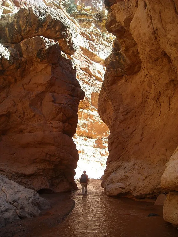
Burro Wash, Capitol Reef
Unmaintained slot canyon with real scrambling / No marked trail, just a drainage and your judgment
Burro Wash is Capitol Reef's way of reminding you that the desert doesn't owe you a trail. This unmaintained slot canyon route drops you into a narrow, twisting drainage where the sandstone walls close in tight enough to block out the sky. You'll scramble over dry-fall pour-offs, chimney between rock walls, and navigate obstacles that demand both upper body strength and problem-solving skills. This isn't a hike — it's a choose-your-own-adventure route through a landscape that floods violently during monsoons and demands complete self-reliance the rest of the year.
When the walls narrow to shoulder width and the sky shrinks to a ribbon of blue overhead, you'll understand why slot canyons inspire both reverence and fear.
The route has no official distance or difficulty rating because conditions change with every flash flood, and what's passable one season might require technical gear the next. You'll need navigation skills, comfort with exposure, and the wisdom to turn around if water pools in the narrows or dark clouds gather upstream. Most people who attempt Burro Wash have experience in unmaintained canyon routes, and those who don't often wish they'd started with something more forgiving. The reward is solitude, adventure, and the satisfaction of navigating a landscape on your own terms.
Golden Throne Trail, Capitol Reef
A steady climb through raw desert to a monolith that glows at sunset / Exposed and waterless
Starting from the Capitol Gorge trailhead, Golden Throne wastes no time letting you know it means business. The trail climbs steadily through slickrock and sandy washes, weaving past water pockets and ancient rock formations that look like they belong on another planet. The terrain is raw desert — exposed, waterless, and unforgiving in summer heat. As you gain elevation, the Golden Throne itself dominates the skyline: a massive Navajo sandstone monolith that earned its name from the way late afternoon light turns it the color of honey.
At the viewpoint, you're close enough to see the vertical jointing and cross-bedding in the sandstone, patterns formed when this was a Jurassic-era dune field the size of the Sahara.
The trail sees far less traffic than Hickman Bridge or Cassidy Arch, which means you'll likely have the Golden Throne to yourself — assuming you're willing to work for it. The climb is relentless but never technical, and the final viewpoint delivers a perspective on Capitol Reef's scale that the roadside pullouts can't match. Most hikers save this one for spring or fall, when temperatures drop below the brutally hot range and the late afternoon light turns the entire Waterpocket Fold into a study in shadow and color.
Sulphur Creek, Capitol Reef
Walking in the creek, not beside it / Three waterfalls you'll downclimb through
Sulphur Creek is not a trail in any traditional sense — it is the creek. You start at the highway bridge west of the visitor center and walk directly into the streambed, spending the next several miles ankle- to knee-deep in water as canyon walls rise around you. The route threads through three small waterfalls that require downclimbing moves, with water cascading over your boots and slickrock handholds that demand careful foot placement. This is adventure hiking in the purest sense: part scramble, part wade, and entirely committed once you drop into the first narrows.
When the canyon walls close in and you're standing waist-deep in a pool beneath a waterfall, debating your next move, you'll realize this is exactly what you came to Capitol Reef to find.
The creek route sees a fraction of the traffic that Grand Wash attracts, partly because it demands more commitment and partly because most visitors don't realize it exists. You'll need shoes that can get wet and stay on your feet, and you'll want to check recent trip reports for water levels — too low and you're walking through mud, too high and those downclimbs become swims. The route exits near the visitor center, which means you'll need a shuttle or a long road walk back to your starting point. Smart hikers leave early, bring dry clothes for the car, and accept that they're going to get thoroughly soaked.
Sunrise/Sunset Point Trail, Capitol Reef
Just over a mile to panoramic views of the Waterpocket Fold / Natural sandstone staircase
This quick out-and-back punches well above its weight. From the trailhead along the Scenic Drive, you'll climb a gentle slickrock slope that functions like a natural sandstone staircase, with the red and white layers of the Waterpocket Fold unfurling around you. The elevation gain is modest — about the same as climbing to the top of a twenty-story building — but the payoff arrives fast. Within half an hour, you're standing on a promontory with views that stretch across Capitol Reef's entire geologic story, from the dark Chinle badlands to the white Navajo domes.
The name tells you when to arrive, but even at midday, this viewpoint delivers a geography lesson you can read in the tilted rock layers.
Families with young kids manage this trail regularly, and photographers treat it like a studio with perfect natural lighting. The slickrock surface means no mud and minimal erosion, though you'll want to watch your footing on the steeper sections where sandstone can be slippery when dusty. Most visitors save this for sunset, which turns the Waterpocket Fold into bands of orange and red, but sunrise delivers equally good light with cooler temperatures and better chances of solitude. The trail sees heavy traffic during peak season, but the viewpoint is spacious enough that you won't feel shoulder-to-shoulder even when the parking lot is full.
Hickman Bridge Trail, Capitol Reef
Two miles to a natural bridge the size of a building / Front-loaded elevation gain
Starting from the parking area along Highway 24, Hickman Bridge wastes no time climbing. You'll gain most of the elevation in the first half mile on a well-worn but rocky path that switchbacks up through dark Kayenta Formation rock. The effort is modest — think climbing a few flights of stairs repeated several times — but enough to filter out visitors looking for a flat stroll. As you gain elevation, the views open across the Fremont River valley to the white sandstone domes that give Capitol Reef its name.
The bridge itself spans a gap wide enough to park a school bus, carved from Kayenta sandstone over millennia of freeze-thaw cycles and erosion.
Most visitors treat this as their introduction to Capitol Reef, which means you'll share the trail with families, retirees, and first-time hikers managing just fine. The path is well-maintained and clearly marked, with interpretive signs explaining the geology and human history along the route. You can reach the bridge viewpoint, snap your photos, and return to your car in under two hours, which makes this the perfect choice when you're short on time but still want to say you hiked to something iconic. The trail sees heavy traffic during peak season, but the bridge is large enough that you won't feel crowded even when multiple groups arrive simultaneously.
Grand Wash Trail, Capitol Reef
Four miles through towering narrows / Flat walking, dramatic walls
Grand Wash is Capitol Reef's gateway canyon — a flat, sandy stroll between towering Navajo sandstone walls that climb hundreds of feet on either side, close enough in places that you could almost touch both walls at once. The trail follows a dry wash bed through one of the park's most dramatic narrows, where the canyon floor stays in shadow for most of the day and the sky shrinks to a ribbon of blue overhead. You'll gain almost no elevation, which makes this accessible to hikers of all abilities, but the distance and exposure to flash flood danger mean you still need to pay attention.
When the walls close in to arm's width and you're walking through a corridor carved by millions of years of water, geology stops being abstract and becomes physical.
The wash sees heavy traffic because it's easy, accessible from both ends, and delivers the kind of dramatic scenery that makes people pull out their cameras every fifty feet. You can turn around whenever you want, but most hikers push through to the opposite trailhead for the full experience. The sandy floor makes for easy walking, though your feet will work harder than on a paved path. Never enter if there's any chance of rain — flash floods funnel through this canyon with violent force, and there's nowhere to climb out once you're in the narrows.
Fruita Historic District Trail, Capitol Reef
A two-mile loop through Mormon settlement remnants / More cultural history than elevation
This is less a hike and more a wander through time. The Fruita Historic District Trail loops you through what remains of a tiny Mormon settlement tucked into the Fremont River valley — weathered log cabins, a one-room schoolhouse, and a barn that looks like it belongs in a painting. The path is nearly flat, following dirt roads and footpaths through orchards that still produce fruit you can pick during harvest season. You'll gain almost no elevation, which makes this perfect for early morning stretches or late afternoon strolls when you've already burned your legs on something steeper.
In late June through early October, you can walk into the orchards and pick apples, pears, or cherries from trees planted more than a century ago by settlers who thought this isolated valley was worth staying for.
Families with small children manage this loop without drama, and history buffs treat it like an outdoor museum where you can touch the exhibits. The orchards attract deer in early morning and evening, and the Fremont River provides a rare sound of running water in the high desert. This isn't the trail you came to Capitol Reef for, but it's the one you'll remember for offering a glimpse into the human story behind the geology. Most visitors combine this with a stop at the Gifford House for pie and a tour of the preserved homestead.
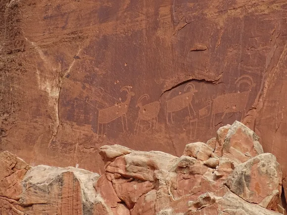
Petroglyph Panel, Capitol Reef
Flat boardwalk to thousand-year-old rock art / Accessible to wheelchairs
This is less of a hike and more of a stroll with a thousand-year-old payoff. A flat boardwalk runs along the base of a towering Wingate sandstone cliff just off Highway 24, where the Fremont people pecked dozens of figures into the dark desert varnish between 600 and 1300 CE. You'll see bighorn sheep, human figures, and abstract designs that archaeologists are still debating the meaning of, all preserved in the dry desert air like a message left by people who knew this canyon long before it became a national park.
Standing at the panel, you realize these aren't museum pieces behind glass — they're messages carved into living rock, still sitting exactly where ancient hands left them.
The entire walk takes less than thirty minutes, which makes this the perfect stop when you need to stretch your legs but aren't dressed for a real hike. Families with strollers manage the boardwalk without issue, and photographers arrive in early morning or late afternoon when the low-angle light brings out the contrast in the petroglyphs. The panel sits close enough to the highway that you'll hear occasional traffic, but the setting beneath the towering cliff face gives the site a presence that transcends the convenience. This is Capitol Reef's most accessible cultural site, and the one that reminds you that humans have been drawn to this landscape for far longer than the National Park Service has existed.