7 National Parks Shaped by Fire
Seven parks where volcanoes and geothermal systems still reshape the ground beneath your boots
Fire built these seven parks, and in most of them, it never stopped. Volcanoes and geothermal systems don't follow human timelines. They bubble, erupt, and reshape terrain whether you're watching or not. What sets these parks apart is how visible that process remains: you can walk across lava flows younger than your grandparents, stand over boiling mudpots that didn't exist a decade ago, or watch bears fish streams fed by glaciers clinging to active volcanic peaks.
The parks below split into two camps. Three deliver accessible geothermal spectacle with infrastructure that gets families to boiling springs and lava tubes in minutes. Four demand floatplanes, high-clearance vehicles, or the willingness to hike above treeline in weather that changes faster than you can layer up. Choose based on how much effort you want between you and the fire.
Yellowstone National Park
Half of Earth's geysers in one park / Bigger than Rhode Island and Delaware combined
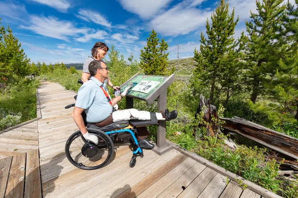
Yellowstone sits on a supervolcano that last erupted 640,000 years ago and shows no signs of going dormant. The caldera spans most of the park, and the magma chamber beneath it heats more than 10,000 hydrothermal features. Old Faithful erupts every 90 minutes like clockwork, but Grand Prismatic Spring is the real draw: a pool the size of a football field ringed in microbial mats that shift from deep blue to rust orange depending on water temperature. You can walk right up to the edge on a boardwalk that keeps you off fragile thermal crust thin enough to break through.
Yellowstone doesn't just have geysers — it has half of all the geysers on the planet, more than Iceland and New Zealand combined.
The park's volcanic origins show up in less obvious ways too. The Grand Canyon of the Yellowstone cuts through rhyolite lava flows, exposing rock that glows yellow and pink from hydrothermal alteration. Lamar Valley's bison herds graze on grasslands fed by volcanic soil. Even the park's famous wildlife concentrations trace back to nutrient-rich geology shaped by eruptions. April brings mud season and road closures, but it also means fewer tour buses and better odds of seeing grizzlies fresh out of hibernation.
Hawaiʻi Volcanoes National Park
Two active volcanoes still building the island / Walk across lava flows younger than you are
Kīlauea erupted almost continuously from 1983 to 2018, adding 500 acres of new land to the island before collapsing its summit crater and rewriting the park map. The 2018 eruption drained the lava lake at Halemaʻumaʻu Crater and dropped the crater floor by 1,600 feet. You can peer into that void from Crater Rim Trail overlooks, then drive Chain of Craters Road down to the coast where black sand beaches meet tide pools carved from cooling lava. Thurston Lava Tube drops you into a subway tunnel carved by molten rock, complete with dripping ferns at the entrance.
The park doesn't preserve a landscape — it documents one still forming, sometimes faster than geologists can map it.
Kīlauea Iki Trail descends into a crater that erupted in 1959 and still vents steam through cracks in the hardened lava lake. The four-mile loop crosses the crater floor where you can feel residual heat rising through your boots, then climbs back through rainforest growing on century-old flows. April is the park's quietest month, with mild temperatures in the low 70s and fewer crowds at popular trailheads. Rangers lead weekly programs at the Jaggar Museum site explaining the 2018 eruption's impact on the summit area.
Lassen Volcanic National Park
Last Cascade volcano to erupt before Mount St. Helens / Boiling mudpots you can smell from the parking lot
Lassen Peak blew its top more than 300 times between 1914 and 1917, sending ash plumes visible from Sacramento and lahars that swept down valley floors. The Devastated Area Trail walks through a landscape still recovering a century later: scattered boulders the size of cars, sparse tree regrowth, and interpretive signs explaining how a volcanic blast zone slowly rebuilds. Bumpass Hell delivers the park's most concentrated geothermal display: boiling springs, hissing fumaroles, and mudpots that pop and gurgle like bad plumbing. The boardwalk keeps you above ground hot enough to melt boot soles.
Lassen holds all four volcano types in one park — shield, composite, cinder cone, and plug dome — a geology textbook you can hike through in a weekend.
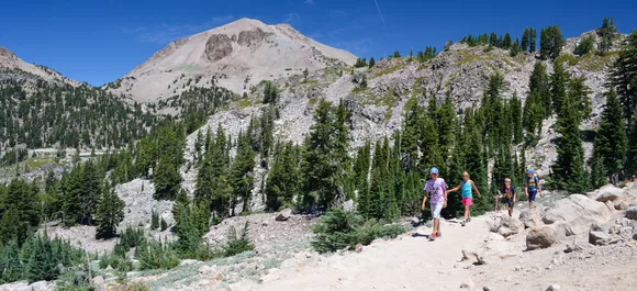
The park stays quiet even in summer, absorbing its visitors across trail systems that rarely see shoulder-to-shoulder traffic. Lassen Peak Trail climbs 2,000 feet over five miles to a summit that surveys the entire park, from Manzanita Lake's pine-ringed shore to Cinder Cone's black slopes. April brings road closures from lingering snowpack, but by August the high country opens fully and temperatures peak in the low 60s. Kids love the mudpots at Bumpass Hell and Sulphur Works, where the smell of rotten eggs and the sight of boiling mud make geology tangible.
Mount Rainier National Park
More glacial ice than all other Cascade volcanoes combined / Visible from Seattle on clear days
Mount Rainier carries 25 named glaciers on a single peak, more than any mountain in the Lower 48. The volcano last erupted in the 1840s, but its geothermal systems keep fumaroles active near the summit crater. You won't see lava flows or boiling springs at trailhead elevation, but the mountain's volcanic origins shape everything: glaciers carve valleys through layered andesite, meltwater feeds rivers that drop through old-growth forest, and wildflower meadows bloom on volcanic soil at Paradise. The Nisqually Glacier's terminus retreated more than a mile since 1900, exposing fresh moraine you can walk across on the Nisqually Vista Trail.
Rainier dominates the horizon so completely that locals call it simply "the mountain," as if no other peak matters.
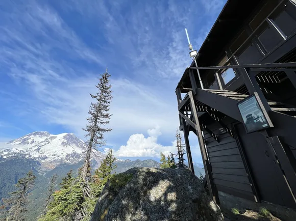
Paradise delivers the park's most popular trails, and in July that means parking lots fill by 9 AM. The Skyline Trail climbs through meadows where lupine, paintbrush, and avalanche lilies bloom against the Nisqually Glacier's toe. Comet Falls drops 320 feet through a slot canyon carved by glacial meltwater. April brings unpredictable conditions — snow still covers high-elevation trails, and road access above Longmire depends on plowing schedules. If you visit in June, you'll catch peak snowmelt waterfalls and wildflowers just starting to emerge at Paradise.
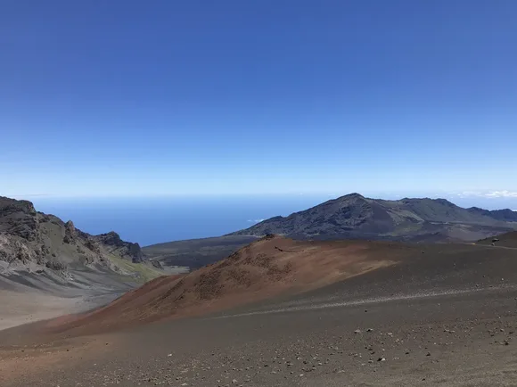
Haleakalā National Park
Summit stands above 90% of Earth's atmosphere / Drive from tropical coast to alpine desert in 40 minutes
Haleakalā's summit crater spans seven miles across and drops 2,600 feet deep, though geologists argue it's not a true crater but rather an erosional valley between volcanic vents. The distinction won't matter when you're standing at the rim watching sunrise light move across cinder cones that glow red, yellow, and black against shadow. The Sliding Sands Trail descends into that basin, dropping through alpine shrubland into a moonscape where hikers look like ants against the scale. Eleven miles in, you'll reach the valley floor where cabins offer overnight stays if you reserve months ahead.
The summit's thin air and lack of light pollution make Haleakalā one of the best stargazing sites in the national park system.
The park splits into two sections: the summit crater and the Kīpahulu coast, connected by name only. Kīpahulu delivers waterfalls, bamboo forests, and the Pools of 'Ohe'o where streams cascade into terraced basins above the ocean. April avoids peak summer crowds, but May draws more visitors than any other month. Sunrise requires reservations and a 3 AM departure from lower elevations. If you skip the sunrise spectacle, you'll find the summit nearly empty by midday, with better visibility once morning clouds burn off.
Katmai National Park & Preserve
Home to more brown bears than people / Valley of Ten Thousand Smokes still steams a century after eruption
Novarupta's 1912 eruption ranks as the 20th century's most powerful volcanic blast, 30 times larger than Mount St. Helens. The explosion buried Katmai Valley under 700 feet of ash and pumped so much magma from beneath Mount Katmai that its summit collapsed into a caldera now filled by a crater lake. The Valley of Ten Thousand Smokes spreads across 40 square miles of ash flow, still venting steam through fumaroles though far fewer than the thousands that gave it the name. You reach the valley via bus tour from Brooks Camp, then hike into terrain that looks more like Mars than Alaska.
Brooks Falls concentrates more brown bears in one viewable space than anywhere else on Earth — up to 25 at the peak of the salmon run.
Most visitors fly into Katmai for the bears, not the volcanic history, but the two intertwine. Brooks River's salmon runs feed bears fattening up for hibernation, and those runs depend on watersheds shaped by volcanic terrain. The elevated platforms at Brooks Falls let you watch bears snatch sockeye mid-leap from July through September. April sits outside the practical visit window unless you're prepared for unpredictable weather and minimal services. June offers the best combination of accessible wildlife and fewer crowds before peak season kicks in.
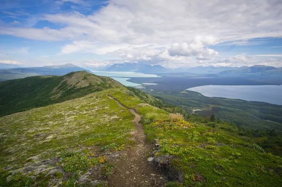
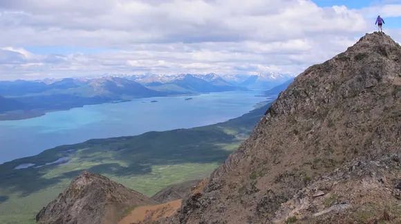
Lake Clark National Park & Preserve
Two active volcanoes visible from the lakeshore / No roads in, floatplane only
Mount Redoubt erupted as recently as 2009, sending ash plumes 50,000 feet high and coating Anchorage in gray dust. Mount Iliamna vents steam year-round from fumaroles near its summit, visible as white plumes against snow when weather clears. Both volcanoes anchor Lake Clark's southern boundary, rising above a 42-mile glacial lake so blue it looks photoshopped. You reach the park via floatplane from Anchorage or Port Alsworth, landing on the lake itself or on gravel bars along rivers where bears fish for salmon within sight of volcanic peaks.
Lake Clark remains one of the least-visited parks not because it lacks scenery but because it refuses to make access easy.
The park's trail system barely exists — you navigate by ridgeline, game trail, and river corridor. Tanalian Falls Trail offers the only maintained path, climbing through boreal forest to a waterfall overlook in three miles. Beyond that, you're route-finding through tundra where caribou migrate and grizzlies dig for ground squirrels. April brings breakup season when ice cracks and rivers swell, making floatplane access unpredictable. June opens the window for hiking above treeline before mosquito hatches peak in July.