8 National Parks Anyone Can Enjoy From the Car
Eight parks where the views from your windshield rival the trails, and April is the perfect time to visit them all
Not every national park demands a three-day backpacking permit or a predawn summit push. The eight parks here share something rare: you can experience their defining features from the driver's seat, and they're all worth visiting in April when most high-elevation parks are still buried in snow. Whether you need accessibility accommodations, you're traveling with toddlers who refuse to hike, or you simply want to see more ground in less time, these parks deliver without asking you to earn it.
April is the sweet spot for most of these destinations. The desert parks shake off winter cold without descending into summer furnace mode, while coastal and volcanic landscapes emerge from their quieter months. You'll dodge peak-season crowds and find parking lots that don't require circling like vultures.
Acadia National Park
Ranked eighth in visitation nationwide / Park Loop Road delivers ocean meets granite
Park Loop Road is a 27-mile ribbon that connects everything that makes Acadia remarkable: Thunder Hole's tidal explosions, Sand Beach's granite-framed cove, and the steady climb up Cadillac Mountain. You can drive the entire loop in two hours, but you'll want four. Every pullout reveals another angle on the Atlantic crashing into pink granite cliffs, and the Jordan Pond overlook frames the Bubbles like a vintage postcard you didn't know still existed.
Acadia is the rare park where staying in your car doesn't feel like cheating — the road IS the experience.
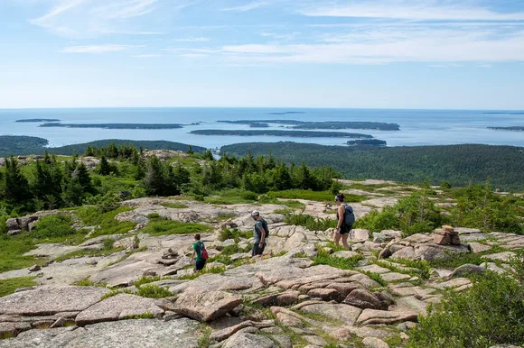
The carriage roads add another 45 miles of car-free, crushed-stone paths perfect for wheelchairs, strollers, and anyone who wants forest without grades steeper than six percent. John D. Rockefeller Jr. designed them specifically to be gentle, and they wind past streams and bridges with zero automobile intrusion. April means you'll miss the fall color stampede but catch the park before it becomes shoulder-to-shoulder in August.
Badlands National Park
Sixty million years of erosion on display / Wide-open grasslands absorb the crowds
Badlands Loop Road cuts through 31 miles of sculptured mudstone that looks like the moon forgot to take its minerals with it. The Door Trail parking lot sits right at the trailhead, but you don't need to walk a single step to see the formations — the road itself runs along the base of the Badlands Wall, a 60-mile escarpment that shifts from white to rust to lavender depending on the time of day. Every pullout offers a different cross-section through ancient seas, volcanic ash, and the bones of creatures that haven't walked the planet in 30 million years.
The Badlands look fragile from a distance and indestructible up close — every spire has survived centuries of wind that should have leveled it by now.
The Fossil Exhibit Trail is paved, wheelchair-accessible, and parks you directly in front of replicas of the ancient rhinoceros and saber-toothed cat bones embedded in these hills. Kids press their noses to the glass cases while parents realize this isn't a geology lesson — it's a crime scene from the Oligocene. April brings wildflowers to the mixed-grass prairie and temperatures mild enough that you can leave the air conditioning off and actually hear the silence.
Bryce Canyon National Park
Earth's densest hoodoo forest / Expect parking lot waits in peak season
The 18-mile scenic drive connects 13 viewpoints, each one revealing a different amphitheater of orange spires carved by freeze-thaw cycles that happen 200 times a year. Sunrise Point and Sunset Point are the headliners, but Bryce Point sits 400 feet higher and gives you the full sweep of the plateau dropping into hoodoo chaos. You can see the entire park from your windshield, though the Navajo Loop tempts almost everyone to descend into the forest itself.
Bryce is proof that erosion can be more creative than construction — every hoodoo looks like it was sculpted by an artist who kept changing their mind.
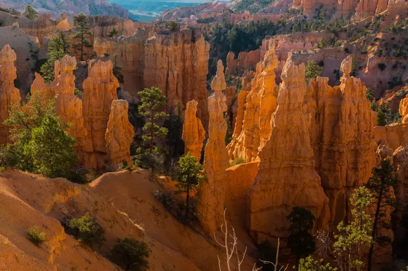
Rainbow Point, the road's terminus, sits at 9,115 feet and overlooks three states on clear days. The drive climbs gently through ponderosa and bristlecone pine forests that don't exist at the canyon's base, and the air temperature drops 10 degrees from rim to rim. April means the road is fully open (it closes periodically in winter) but the summer crowds haven't arrived yet. You'll actually find parking at the popular overlooks without circling.
Grand Canyon National Park
Draws more visitors than any park except the Smokies, Zion, and Yellowstone / The canyon's size keeps it from feeling packed
Desert View Drive runs 25 miles along the South Rim, connecting seven overlooks that each reframe the canyon's impossible scale. Mather Point is the default first view, but Lipan Point and Desert View reveal layers of rock that Mather hides behind its own cliffs. The Watchtower at Desert View, designed by Mary Colter in 1932, gives you 360-degree views from a structure that looks like it grew out of the rimrock instead of being built on it.
The Grand Canyon doesn't gradually reveal itself — it ambushes you at every viewpoint, and your brain refuses to process the depth until you've stared for five full minutes.
Hermit Road adds another seven miles and seven overlooks, and it's closed to private vehicles from March through November — but the free shuttle drops you at every stop, which means you can focus on the views instead of parking logistics. April brings wildflowers to the rim and temperatures in the 60s, cool enough for comfort but warm enough that you won't need layers. The canyon itself doesn't change with the seasons, but the light does. Spring afternoons bring storms that fill the canyon with shadows and shafts of sun that look like stage lighting.
Haleakalā National Park
A dormant volcano you can drive into / Most visitors never make it past the summit
The road to Haleakalā's summit climbs from sea level to 10,023 feet in 38 miles, passing through four climate zones and delivering you above the cloud layer into what feels like another planet. The crater rim overlooks a volcanic depression seven miles across, filled with cinder cones in rust, yellow, and charcoal that look like they're still smoldering. You can see the Big Island's peaks across the channel on clear mornings, and the sunrise draws crowds that fill the summit parking lot by 5 AM.
Haleakalā is the closest you'll get to standing on Mars without leaving Earth — the crater looks less like Hawaii than like the surface of another world entirely.
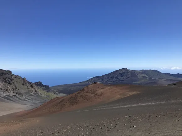
The Kīpahulu District, accessible via a separate road on the coast, drops you into tropical rainforest and pools fed by waterfalls. It's the same park but feels like a different continent. April is one of the park's busiest months, but most visitors cluster at the summit for sunrise and leave by mid-morning. If you arrive after 10 AM, you'll find the crater rim nearly empty and the temperature warm enough that you won't need the winter coat the summit demands at dawn.
Mesa Verde National Park
Most visitors have never heard of it / Seven hundred Ancestral Pueblo dwellings carved into sandstone alcoves
Mesa Top Loop Road delivers ten archeological sites in six miles, all visible from paved pullouts with interpretive signs. You'll see pithouses from 600 CE and pueblos from 1100 CE, watching 500 years of architectural evolution unfold without leaving your car. Cliff Palace and Balcony House require ranger-led tours and ladder climbs, but Spruce Tree House sits below a short, paved overlook trail that shows you a 130-room dwelling tucked into an alcove that protected it from weather for 700 years.
Mesa Verde is the only national park that protects human history instead of natural landscapes — and the architecture is more impressive than most modern buildings.
The drive to the mesa top climbs 2,000 feet through pinyon-juniper forest on a road with more switchbacks than seem structurally necessary. April is the park's best month: spring green softens the plateau, temperatures stay in the 60s, and the summer tour crowds haven't arrived yet. You can often get same-day tickets for Cliff Palace, which is nearly impossible in July.
Petrified Forest National Park
Trees turned to stone sprawl wider than cars / Most visitors have never heard of it
The 28-mile park road connects the Painted Desert's lavender badlands to the petrified logs of the southern section, passing through 225 million years of rock in less than an hour. Blue Mesa Trail's parking lot sits at the trailhead of a one-mile paved loop, but the overlook at the parking area shows you the bentonite hills in layers of gray, purple, and blue without requiring you to walk a single step. The logs themselves are scattered across the grassland like fallen columns from a ruined temple, each one a cross-section of agate and jasper that glitters when the sun hits it right.
Petrified Forest makes you reconsider what qualifies as "wood" — these trees weigh tons and ring like ceramic when you tap them.
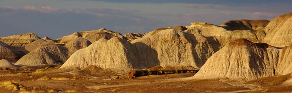
Route 66 runs through the park's northern section, and the Painted Desert Inn sits on the rim with murals by Hopi artist Fred Kabotie and views that stretch 50 miles on clear days. April brings mild temperatures and wildflowers to the grasslands, and the park's sheer size means you'll rarely see another car on the road. This is one of the few parks where you can drive the entire length without encountering a traffic jam.
Rocky Mountain National Park
Trail Ridge Road crosses the Continental Divide at 12,183 feet / More visitors than Los Angeles has residents
Trail Ridge Road is the highest continuous paved road in America, climbing above treeline for 11 miles and delivering alpine tundra views without requiring you to hike. The road doesn't open until late May most years, but when it does, you'll drive through ecosystems that only exist above 11,000 feet: krummholz forests where trees grow horizontally instead of vertically, wildflower meadows that bloom for six weeks and sleep for 46, and tundra that looks like arctic Canada transplanted to Colorado.
Trail Ridge Road is less a scenic drive than a vertical journey through climate zones that usually require a plane ticket and a passport.
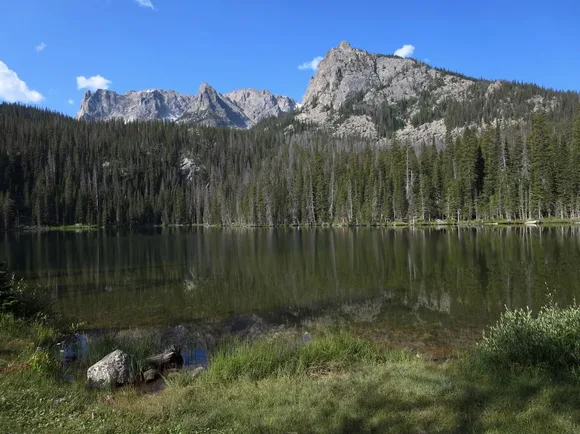
Bear Lake Road offers a lower-elevation alternative, connecting glacial lakes and trailheads through subalpine forest. The road dead-ends at Bear Lake, where a paved half-mile loop circles the water and gives you views of Hallett Peak and Longs Peak without any elevation gain. April is too early for Trail Ridge, but Bear Lake Road stays open year-round, and you'll catch the park between winter closures and summer crowds.