8 National Parks Built Around Canyons
Eight parks where canyons define the landscape, from limestone caverns to river gorges that trap sunlight for minutes a day
A canyon is more than a crack in the earth. It's a record of rivers cutting through time, exposing layers of rock that tell stories spanning millions of years. These eight parks take that geologic drama and amplify it — some with sheer walls that trap sunlight, others with layered amphitheaters that rewrite what you thought a canyon could be. April hits the sweet spot: snow has cleared from higher elevations, summer crowds haven't arrived, and desert temperatures stay reasonable enough to hike all day.
What separates these parks isn't just depth or width. It's how each canyon shapes the experience around it — whether you're descending into a limestone cavern carved by acid, navigating slot canyons that require permits and nerve, or standing at overlooks where the scale defeats comprehension.
Arches National Park
The world's highest concentration of natural stone arches / Packed rim-to-rim in peak season
Yes, Arches is famous for its namesake formations — over two thousand of them carved from Entrada sandstone — but the park's canyon country defines how you experience them. Park Avenue drops you between vertical walls that feel more Manhattan than Utah, while Fiery Furnace turns navigation into a three-dimensional puzzle of fins and corridors. Delicate Arch sits at the rim of a sandstone bowl, and the hike to reach it traces a canyon wall with exposure that keeps things interesting.
The arches get the photographs, but the canyons between them are where you understand the forces that shaped this landscape.
April lands in that narrow window when temperatures climb into the 70s without hitting the brutal heat of summer, and wildflowers start appearing in sandy washes. You'll still share Delicate Arch Trail with dozens of other hikers, but early morning starts and late afternoon light keep the experience manageable. Devils Garden stretches for more than seven miles through the park's backcountry, where the concentration of arches thins and the canyon topography becomes the main attraction.
Big Bend National Park
Larger than Rhode Island / So remote you'll forget other parks have traffic jams
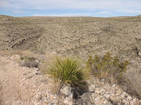
Big Bend's canyons come in two forms: the river gorges carved by the Rio Grande through limestone, and the desert canyons cut into the Chisos Mountains. Santa Elena Canyon walls rise 1,500 feet on both sides of the river, creating a corridor so narrow that sunlight only hits the water at midday. Boquillas Canyon runs longer and wider, with hiking trails that follow the Mexican side of the border through tamarisk thickets and cottonwoods. The Chisos canyons — particularly the Window — funnel seasonal runoff through vertical walls that frame desert vistas you won't see from the main roads.
Big Bend rewards the drive with space that feels increasingly rare in the national park system — room to hike for hours without seeing another person.
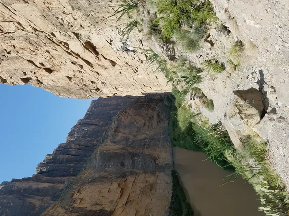
April sits at the tail end of the park's prime season, when temperatures hover in the 80s and desert wildflowers peak after winter rains. The park's size absorbs visitors in ways smaller canyon parks can't match. While Santa Elena Canyon sees steady traffic, you can paddle the river through Mariscal Canyon without encountering another boat. Lost Mine Trail climbs through a Chisos canyon to ridgeline views that stretch into Mexico, and most days you'll have the upper switchbacks to yourself.
Black Canyon of the Gunnison National Park
North America's steepest river gorge / Drops 2,000 feet through rock older than most mountains
Black Canyon earns its name. The Gunnison River carved a chasm so narrow and deep that sunlight reaches the bottom for less than an hour a day in some sections. South Rim Drive traces the edge for seven miles, with overlooks that make your stomach drop: Painted Wall rises higher than any cliff in Colorado, and Chasm View shows you the narrowest point where 1,100 feet separate rim from rim but the walls plunge 2,000 feet to the river. The darkness at the bottom isn't shadow — it's 1.7-billion-year-old Precambrian rock that predates complex life on Earth.
Most canyon parks let you hike to the bottom; Black Canyon makes you earn every foot of elevation on near-vertical routes that require permits and route-finding skills.
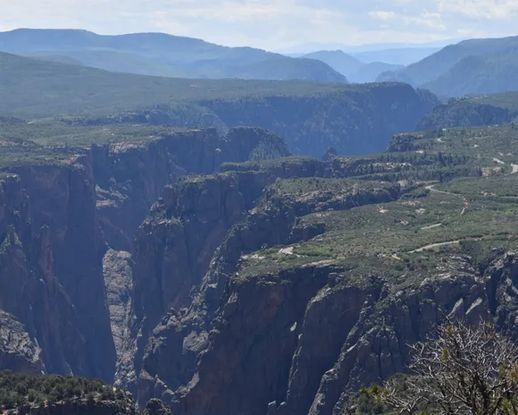
April hits before the July peak season, when crowds concentrate at the major overlooks but leave the rim trails relatively quiet. Warner Point Nature Trail loops through scrub oak and mountain mahogany to views that encompass the entire canyon system. The North Rim sees a fraction of South Rim traffic — the drive adds an hour on dirt roads, but Exclamation Point puts you directly across from Painted Wall with zero guardrails between you and the drop. Fishing the Gunnison requires technical climbing skills to reach the river, but the canyon's inner walls attract climbers who treat the black gneiss as some of the best traditional routes in the country.
Bryce Canyon National Park
Earth's densest hoodoo forest / Draws more visitors than the population of Houston
Bryce Canyon isn't technically a canyon at all — it's a series of amphitheaters carved into the edge of the Paunsaugunt Plateau, where erosion has sculpted orange and white limestone into thousands of hoodoos that pack together like a stone forest. The Navajo Loop drops 500 feet through switchbacks that put you at eye level with formations named Thor's Hammer and Wall Street, where Douglas firs grow in a slot so narrow you can touch both walls. Queens Garden connects to Navajo Loop for a circuit that shows you the full range of what erosion can accomplish at 8,000 feet elevation.
Sunrise Point and Sunset Point deliver exactly what their names promise — the low-angle light sets the iron-oxide-stained limestone on fire in shades that cameras struggle to capture accurately.
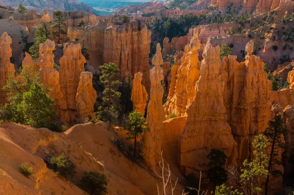
April means cooler temperatures in the 50s and 60s, with possible snow showers that dust the hoodoos white and create contrast that summer visitors never see. The park's popularity means parking lots at major viewpoints fill by midday even in shoulder season, but the Rim Trail extends for more than five miles along the plateau edge with access points that see lighter traffic. Fairyland Loop covers eight miles through the park's northern amphitheaters, where hoodoo density rivals the main section but crowds thin considerably.
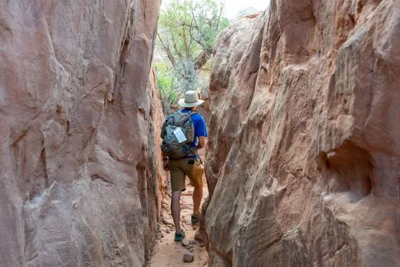
Canyonlands National Park
Four distinct districts larger than Los Angeles combined / Island in the Sky overlooks rival the Grand Canyon for scale
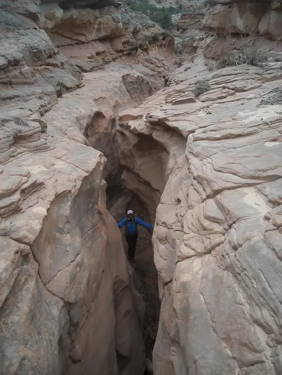
Canyonlands splits into regions separated by the confluence of the Green and Colorado Rivers, and each district offers a different relationship with canyon country. Island in the Sky sits 1,000 feet above the surrounding terrain on a mesa top, with overlooks like Grand View Point that show you layer upon layer of canyons stretching to the horizon. The Needles district trades expansive views for immersive hiking through grabens and slot canyons between striped sandstone spires. The Maze lives up to its name with backcountry so remote that rangers recommend four-wheel-drive, extra fuel, and the ability to self-rescue.
The Colorado and Green Rivers carved the landscape, but it's the subsequent erosion of softer layers that created the labyrinth of side canyons defining each district.
April brings mild days perfect for hiking before summer heat makes lower elevations punishing. Island in the Sky sees the most traffic but offers the easiest access — Mesa Arch frames sunrise views that have become iconic, though you'll share the moment with a dozen photographers. The Needles requires more commitment: Chesler Park Trail loops through a grassland surrounded by sandstone needles, and the Joint Trail squeezes through cracks that require removing your pack. The Maze remains genuinely isolated — permits are easy to obtain because so few people attempt it.
Capitol Reef National Park
A hundred-mile wrinkle in the earth's crust / Still growing pioneer orchards in desert canyons
Capitol Reef protects the Waterpocket Fold, a monocline where rock layers bend upward at angles approaching vertical before dropping back down — creating a landscape where canyons cut perpendicular to the fold expose different geological eras within miles. Grand Wash slices straight through the fold with walls that narrow to 20 feet apart in places, while Capitol Gorge preserves pioneer inscriptions on walls that Mormon settlers used as a wagon route. Hickman Bridge spans 133 feet across a side canyon, and the trail to reach it climbs through layers that shift from red Kayenta sandstone to white Navajo sandstone in half a mile.
The Fruita Historic District plants orchards in canyons where seasonal water allowed Mormon settlers to grow fruit that still ripens every summer — you can pick cherries in June and apples in September under a permit system that feels anachronistic until you taste them.
April hits ideal temperatures in the 60s and 70s before the triple-digit heat arrives, and the orchards bloom white and pink against red canyon walls. Capitol Reef sees fewer visitors than its Utah neighbors despite similar geology — the park's linear shape along Highway 24 concentrates traffic near Fruita while leaving the northern and southern districts nearly empty. Cathedral Valley requires high-clearance vehicles and adds hours of driving on dirt roads, but the Temples of the Sun and Moon formations rise from a valley floor surrounded by canyon walls in colors that shift from cream to rust depending on the light.
Carlsbad Caverns National Park
A limestone cavern longer than six football fields / Carved by sulfuric acid rising from oil deposits below
Calling Carlsbad Caverns a canyon park requires redefining what a canyon can be. The Big Room sits 750 feet underground — a chamber covering more than eight acres with a ceiling that vaults 250 feet overhead in places. Natural Entrance Trail descends through the actual canyon: a sinkhole that drops through layers of Permian reef limestone into passages where formations grow both up and down. Unlike most caves carved by slightly acidic groundwater over millions of years, Carlsbad formed quickly in geologic terms when hydrogen sulfide from oil deposits mixed with oxygen-rich water to create sulfuric acid that dissolved the limestone.
The bat flight program turns dusk into theater — up to 400,000 Mexican free-tailed bats spiral out of the Natural Entrance in a tornado that can last more than two hours during peak season.
April sits early in the bat season — the colony returns from Mexico in late March, with numbers building through summer. The cavern maintains a constant 56 degrees year-round, which feels refreshing when surface temperatures climb into the 90s but requires a jacket in any season. The Big Room Trail loops for more than a mile past formations with names like the Bottomless Pit and Rock of Ages, and rangers lead specialized tours into sections like Kings Palace and Slaughter Canyon that show different cave systems within the same reef complex. Surface trails above the caverns traverse Chihuahuan Desert canyons where agave and sotol grow on limestone slopes that hint at the reef structure below.
Death Valley National Park
Larger than Connecticut / Low enough and hot enough to kill you six months of the year
Death Valley contains dozens of canyons, but most visitors never see them. Golden Canyon winds through badlands where oxidized minerals paint the walls in shades of yellow and rust, with side passages that lead to Red Cathedral — a natural amphitheater where iron-stained walls rise 400 feet. Mosaic Canyon cuts through marble polished smooth by flash floods, creating passages that narrow to shoulder-width before opening into chambers filled with breccia where rock fragments fused into chaotic patterns. Titus Canyon requires four-wheel-drive for a one-way descent through narrows that barely fit a vehicle, with petroglyphs and a ghost town marking the route pioneers used to reach mining claims.
April pushes the edge of safe visitation — Badwater Basin temperatures climb into the 90s, and by May you're gambling on whether afternoon heat will top 110 degrees.
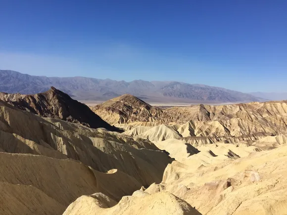
The park's scale works in your favor: while Badwater Basin and Zabriskie Point concentrate visitors at the valley floor and overlooks, the canyon hikes stay relatively quiet. Golden Canyon Trail connects to Gower Gulch for a loop that shows you how erosion carved the badlands layer by layer, and most hikers turn around at the first narrows. Fall Canyon and Desolation Canyon on the northern end require dirt road access but deliver true slot canyon experiences with walls that block the sky. The valley's below-sea-level elevation means you can hike rim trails in the Panamint Mountains while valley temperatures exceed safe limits — Telescope Peak Trail climbs to 11,000 feet with views that span from the lowest to some of the highest points in the lower 48.