8 National Parks Built for a Slower Pace
Eight national parks where paved paths, gentle grades, and accessible infrastructure deliver views without the scramble
Somewhere between the park service brochures promising adventure and the reality of your knees, there's a different kind of national park experience. You don't need to scramble up scree fields or hike rim-to-river to earn the views. These eight parks were designed, sometimes literally, for visitors who prefer pavement to rock-hopping and choose their trails by grade rather than glory. April brings mild temperatures and thinner crowds to most of them, which means you can actually stop to look at things without someone breathing down your neck.
The usual suspects make the list because they genuinely deliver: accessible viewpoints, paved paths, and infrastructure built when the park service still believed in making nature convenient. But you'll also find a few surprises where the terrain itself does the heavy lifting and the trails stay mercifully flat.
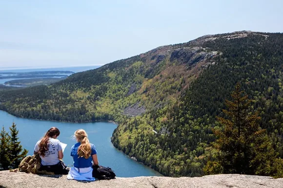
Acadia National Park
45 miles of carriage roads banned to cars since 1917 / More visitors than Los Angeles has people
John D. Rockefeller Jr. spent two decades building carriage roads through Acadia specifically to keep cars out. What started as wealthy-tourist infrastructure in the 1920s now serves as the park's secret weapon for accessible exploration. These crushed-stone paths run wide and smooth, with grades that rarely test your lungs. The Jordan Pond loop delivers postcard views of the Bubbles mountains without requiring you to climb them, and the whole three-mile circuit stays flat enough that wheelchairs and walkers navigate it without drama.
Rockefeller's carriage roads feel like walking through a granite sculpture garden where the ocean keeps photobombing the view.
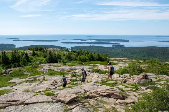
April sits right before the summer crush descends. You'll find parking at Jordan Pond without circling like a vulture, and the weather hovers in the 50s without the August humidity that turns short walks into endurance tests. The Cadillac Mountain summit road delivers sunrise views without the hike, though you'll share the experience with a crowd that starts gathering at 4 AM. Skip the sunrise theater and drive up mid-morning instead. The view doesn't diminish just because you slept past dawn.
Hot Springs National Park
Smallest park footprint in the system / Bathhouse Row draws crowds that pack downtown sidewalks
Hot Springs occupies barely more ground than a large subdivision, wedged into downtown Hot Springs, Arkansas, where the national park boundary runs right up against tattoo parlors and gift shops. The thermal water still flows at 143 degrees from the mountain, just as it did when gangsters soaked next to health seekers in the 1920s. Two bathhouses remain operational, and you can book a traditional soak that feels closer to spa treatment than wilderness experience. The Grand Promenade behind Bathhouse Row runs flat and brick-paved for half a mile, with benches every hundred feet and no elevation gain to speak of.
Most national parks ask you to meet nature on its terms; Hot Springs pipes nature directly into a marble tub.
April brings azaleas and dogwoods into bloom across the mountainside trails, and temperatures sit comfortably in the 60s and 70s. The park's trail system climbs into the surrounding Ouachita Mountains, but you can skip all of it and still claim you've done Hot Springs properly. The thermal water display fountain on the promenade flows free and hot enough to brew tea, which visitors do regularly despite park service sighs. If you want actual hiking, the Hot Springs Mountain Trail gains elevation gradually over three miles to the observation tower, but the tower elevator saves you the final climb.
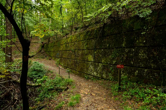
Cuyahoga Valley National Park
20-mile towpath older than the park itself / Crowds stay manageable even in peak season
The Ohio & Erie Canal towpath predates the national park by 175 years, which means the Park Service inherited a perfectly flat, perfectly maintained trail that runs 20 miles along the Cuyahoga River without a single switchback. Mules once pulled canal boats along this path. Now it carries cyclists, walkers, and wheelchairs through a deciduous forest corridor that somehow survived between Cleveland and Akron's suburban sprawl. The Brandywine Falls boardwalk brings you face-to-face with a 65-foot cascade via a quarter-mile paved trail with benches at every overlook.
Cuyahoga Valley proves you can wedge a national park between two cities and still find quiet, as long as you build enough trail to spread people out.

April turns the forest floor into a wildflower show, with trillium and spring beauties carpeting the understory before the canopy leafs out. The park offers zero campgrounds but sits close enough to both Cleveland and Akron that day visits work perfectly. The Cuyahoga Valley Scenic Railroad runs vintage trains through the park with wheelchair-accessible cars and station stops at major trailheads. You can ride the train one direction and walk the towpath back, or just stay on board and let someone else handle the navigation.
Mammoth Cave National Park
The world's longest cave system / Deserves far more attention than it receives
Mammoth Cave doesn't ask you to climb into the earth so much as descend gradually through a historic entrance that's been welcoming tourists since 1816. The cave maintains a constant 54 degrees year-round, which means April weather matters less underground than at any other national park. Ranger-led tours range from easy paved routes to challenging crawls through tight passages, but the Historic Tour covers two miles on mostly flat brick pathways installed during the Great Depression. You'll see Gothic Avenue's 40-foot ceilings and the Rotunda's 19th-century tuberculosis hospital remains without testing your knees.
Walking through Mammoth Cave feels like touring a natural cathedral where the acoustics swallow sound and the darkness presses close enough to touch.
Above ground, the park spreads across Kentucky's limestone plateau with 85 miles of surface trails that stay surprisingly flat. The Green River Bluffs Trail runs 3.6 miles along the riverbank with moderate elevation changes and spring wildflowers that rival any mountain meadow. April brings mild temperatures that make surface hiking pleasant before summer humidity turns the forest into a steam room. Cave tours book solid during summer, but April sees enough empty spots that walk-up tickets sometimes materialize.
Gateway Arch National Park
Covers less ground than a shopping mall / Draws more visitors than almost any park in the system
Gateway Arch National Park occupies a downtown St. Louis riverfront footprint smaller than most suburban parking lots. The 630-foot steel arch dominates the view, and the tram to the top requires boarding a tiny egg-shaped pod that climbs through the arch's interior like a very slow, very weird elevator. The ride up takes four minutes, and claustrophobia is a legitimate concern. Once you reach the top, tiny windows offer views across the Mississippi River and the city sprawl beyond. The museum beneath the arch covers westward expansion history with enough depth to justify the visit even if you skip the tram entirely.
The Gateway Arch works best as a museum visit with a monument attached, not the other way around.
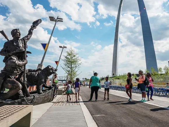
April weather makes the riverfront grounds actually pleasant for walking, before summer heat turns the open plaza into a concrete griddle. The park's two trails total barely a mile combined, all paved and flat. You can see everything Gateway Arch offers in half a day, which leaves time for St. Louis barbecue and the City Museum downtown. This isn't wilderness, and the park service doesn't pretend otherwise. It's presidential monument meets urban green space, built for visitors who want national park credentials without leaving city limits.
Indiana Dunes National Park
15 miles of Lake Michigan shoreline / Plant diversity that exceeds most parks ten times its size
Indiana Dunes packs more plant species into its small footprint than almost anywhere else in the park system, a biological quirk that thrills botanists and mostly confuses everyone else. What matters more for most visitors: the beaches stretch flat and wide along Lake Michigan, the trails stay mostly level, and Chicago sits close enough that you can drive out for the day without committing to wilderness camping. West Beach offers a paved parking lot, accessible bathrooms, and a beach that requires zero climbing to reach. The Dune Succession Trail explains how plants colonize sand over centuries, but mostly it delivers lake views without making you earn them.
Lake Michigan's southern shore feels like an ocean beach until you taste the water and remember you're in the middle of the continent.
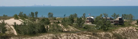
April finds the lake still frigid and the crowds still sparse. The park's proximity to Chicago means summer weekends pack the beaches shoulder-to-shoulder, but spring visits deliver actual space to breathe. The Bailly-Chellberg Trail loops two miles through pioneer homestead history and oak savanna without significant elevation gain. Mount Jackson rises to the park's highest point at 176 feet, which qualifies as a hill anywhere else but counts as a mountain in Indiana's relentlessly flat landscape. Skip it if your knees complain.
Badlands National Park
Layered rock spires carved by 500,000 years of erosion / Draws crowds but space absorbs them
The Badlands Wall rises abruptly from South Dakota grassland like a fortress made of layered sediment and time. The Door Trail boardwalk penetrates the formations for a quarter mile on perfectly flat, perfectly accessible pavement, delivering you into an alien landscape of spires and pinnacles without requiring any scrambling. The Fossil Exhibit Trail runs another quarter mile, also paved, with cast replicas of the ancient rhinos and three-toed horses whose bones still erode from the rock. If you want actual hiking, the Castle Trail extends five miles across mixed-grass prairie, flat enough that elevation becomes almost irrelevant.
Badlands geology works in reverse, carving down instead of building up, which means the views improve as the rock disappears.
April brings wildflowers to the prairie and temperatures that hover in the 60s before summer heat makes the exposed trails punishing. The Badlands Loop Road covers 30 miles of pavement with pullouts every few miles, each offering overlooks that require nothing more than parking and walking 20 feet. You can experience the park's iconic views without leaving your car, which feels like cheating until you realize the park service designed it exactly this way. The Pinnacles Overlook at sunset draws crowds, but the formations stretch for miles and dozens of pullouts offer similar views with nobody else around.
Grand Canyon National Park
One mile deep, 277 miles long / The canyon's size absorbs crowds that would overwhelm smaller parks
The Grand Canyon's South Rim Trail runs 12 miles along the canyon edge, mostly paved or hard-packed, with elevation changes that stay gentle enough for wheelchairs and walkers. You can access overlooks every quarter mile without ever descending into the canyon itself, which is where the real work begins and where most visitors wisely choose not to go. Mather Point sits closest to the visitor center and draws corresponding crowds, but walk 15 minutes in either direction and the rim empties out remarkably. The canyon doesn't get less impressive just because you're sharing it with other humans.
The Grand Canyon's size makes humility compulsory—you can't process a mile of vertical depth without your brain briefly shutting down.
April brings mild rim temperatures in the 50s and 60s, before summer heat makes the inner canyon dangerous and the rim uncomfortably warm. The free shuttle system runs between major viewpoints, which means you can walk as much or as little rim trail as your knees allow and catch a ride back. Hermits Rest sits at the western end of the shuttle route, offering canyon views and historic architecture without the crowds that pack Mather Point and Yavapai Overlook. The North Rim remains closed until mid-May, which concentrates April visitors on the South Rim but still leaves plenty of elbow room along 12 miles of viewpoints.