8 National Parks That Will Impress Your Teenager
Eight parks where teenagers trade screen time for slot canyons, coral reefs, and trails that feel like actual adventures
Teenagers are the toughest critics. They've seen enough Instagram feeds to know when something actually delivers, and they're brutally honest about what's worth their time. The good news is that national parks offer the kind of experiences that cut through the digital noise: slot canyons you have to squeeze through sideways, reefs you can snorkel over, and trails that feel less like family bonding and more like actual adventure.
April hits the sweet spot for most of these parks. Desert landscapes bloom before the furnace months arrive, snow has cleared from high-country trails, and spring break crowds have mostly dispersed. You'll find comfortable temperatures, decent trail access, and the kind of conditions that make teenagers forget they're spending time with their parents.
Arches National Park
More than 2,000 natural arches carved from red sandstone / Delicate Arch hikes in April
Arches delivers the kind of scenery that looks Photoshopped even when you're standing in it. Delicate Arch might be Utah's most recognizable landmark, but the three-mile round trip to reach it filters out the casual crowds and rewards you with something worth the effort. The trail climbs across slickrock with zero shade, so April's mild temperatures make it tolerable. Devils Garden offers a longer alternative, where you can string together multiple arches on a single hike and actually feel like you've earned your views.
The sandstone formations here don't just photograph well — they make you want to climb on things, which rangers would prefer you didn't do.
Park Avenue Trail provides an easier option without sacrificing drama. You'll walk between sandstone skyscrapers that dwarf anything humans have built, and the mile-long downhill route means you can arrange a car shuttle and skip the return climb. The park gets packed during peak season, but arrive before 8 AM or after 4 PM in April and you'll have decent elbow room. Balanced Rock sits right off the main road and takes five minutes to reach, perfect for that mandatory photo stop without committing to a full hike.
Capitol Reef National Park
A hundred-mile wrinkle in the earth / Pioneer orchards you can still harvest
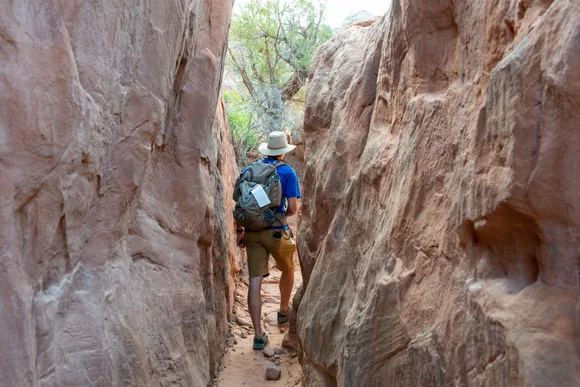
Capitol Reef flies under the radar compared to Utah's other parks, which works in your favor. The Waterpocket Fold sounds like a geology lecture but looks like the earth cracked open and tilted sideways. Hickman Bridge offers a two-mile round trip to a natural bridge that spans more than the length of a football field, and the trail threads through terrain that shifts from desert floor to slickrock overlooks. Grand Wash cuts a flat path between canyon walls that rise 800 feet overhead, narrow enough in spots that you can touch both sides at once.
Most people have never heard of Capitol Reef, which means you can hike trails here that would require a permit and a lottery in Zion.
The Fruita Historic District preserves an old Mormon settlement where you can still pick apples, cherries, and peaches depending on the season. April brings blooming orchards rather than ripe fruit, but the contrast of green trees against red cliffs makes the stop worthwhile. Cassidy Arch pushes into strenuous territory with 700 feet of elevation gain, but you'll end up standing on top of a natural arch with views across Capitol Dome and the surrounding canyons. The Scenic Drive extends beyond the paved section into Capitol Gorge, where a two-mile dirt road leads to a slot canyon so narrow you can barely see sky.
Canyonlands National Park
Four districts carved by the Colorado River / The Maze requires serious commitment
Canyonlands sprawls across an area larger than Rhode Island, divided into districts that each offer different experiences. Island in the Sky provides the most accessible overlooks, where you can stand at Grand Viewpoint and watch canyons layer out to the horizon. Mesa Arch sits a half-mile from the parking lot and frames the landscape through a stone window that photographers crowd at sunrise. The Needles District trades easy access for better hiking, with trails that wind through striped sandstone spires and hidden alcoves.
The white-knuckle drive down Shafer Trail switchbacks feels like descending into another planet, and teenagers will never admit how much they enjoyed it.
Upheaval Dome presents a geological mystery: either a meteor impact crater or a collapsed salt dome, depending on which theory you believe. The overlook trail climbs just under a mile to views of the circular formation, and the debate about its origin makes for better conversation than most family car rides. Chesler Park in the Needles offers a longer commitment with six miles of hiking through a landscape that resembles a stone garden. The Joint Trail connects through a slot canyon so tight you have to turn sideways in spots, delivering the kind of claustrophobic thrill that makes teenagers forget they're exercising.
Acadia National Park
Rocky Atlantic coast crowned by the first sunrise in the U.S. / Cadillac Mountain by bike or car
Acadia compresses mountains, ocean, and forest into an area smaller than most western parks, which means you can sample multiple ecosystems without spending all day in the car. The Precipice Trail closes until mid-August for peregrine falcon nesting, but Beehive Trail offers similar exposure with iron rungs bolted into cliff faces and drops that require actual attention. Jordan Pond Shore Trail loops around mirror-still water with views of the Bubbles Mountains reflected on calm mornings, offering an easier alternative that still delivers postcard scenery.
The carriage roads built by John D. Rockefeller Jr. banned cars a century ago, creating 45 miles of smooth gravel perfect for biking without engine noise.
Thunder Hole lives up to its name when waves crash into a narrow channel and compress air into a boom you can feel in your chest. Timing matters: visit two hours before high tide for the best show. Cadillac Mountain reaches 1,530 feet above sea level, making it the highest point on the North Atlantic seaboard. You can drive to the summit, but the North Ridge Trail climbs seven miles with enough elevation gain to feel earned. Park Loop Road connects the major sites in a 27-mile circuit that you can drive or bike, passing Sand Beach where the water temperature hovers in the 50s even in summer.
Black Canyon of the Gunnison National Park
North America's steepest gorge / 2,000-foot walls that trap the sun
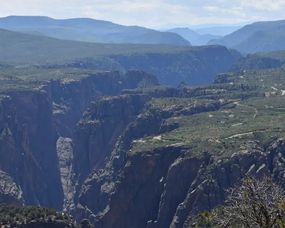
Most people have never heard of Black Canyon, which explains why you can visit in April without fighting crowds at every overlook. The canyon earned its name honestly: walls so steep and narrow that some sections receive only 33 minutes of sunlight per day. South Rim Drive connects 12 overlooks in seven miles, each offering a different perspective on the gorge below. Painted Wall towers 2,250 feet from river to rim, twice the height of the Empire State Building, with lighter-colored granite streaks creating patterns across the dark rock.
The Gunnison River drops an average of 95 feet per mile through the canyon, making it one of the steepest river gradients in North America.
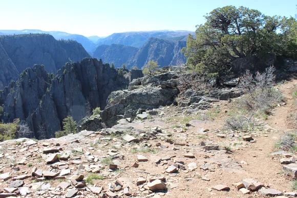
Rim Rock Trail follows the canyon edge for three miles, staying mostly flat while views plunge straight down to the river. Warner Point Nature Trail extends 2.8 miles to the end of the South Rim, where you can see the canyon bend and disappear into the distance. The North Rim requires a longer drive on a gravel road but sees a fraction of the visitors, offering solitude that feels impossible at more famous parks. Expert kayakers occasionally run the river through the canyon, navigating Class V rapids that require portaging around multiple waterfalls.
Big Bend National Park
Chisos Mountains rise from desert / More bird species than any other park
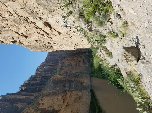
Big Bend occupies a chunk of Texas bigger than Rhode Island, bordering Mexico along the Rio Grande and stretching north into the Chisos Mountains. The park's size and remote location keep crowds manageable even during peak season, and April offers the last comfortable hiking temperatures before summer heat arrives. Santa Elena Canyon cuts through limestone cliffs that rise 1,500 feet above the river, creating a narrow passage you can paddle through or walk alongside on an easy 1.7-mile trail.
You can soak in natural hot springs along the river, then hike to a mountain peak above 7,800 feet — all in the same park.
The Window Trail descends into a V-shaped notch in the mountains where water pours through during rain. Lost Mine Trail climbs nearly 1,200 feet in less than five miles, ending at views that span from Mexico to multiple mountain ranges. Boquillas Canyon offers a different perspective on river-carved geology, with a trail that winds along the Rio Grande and crosses into terrain that feels more remote than it actually is. Night skies here rank among the darkest in the lower 48 states, making Big Bend one of the few parks where teenagers might actually look up from their phones after sunset.
Biscayne National Park
Miami's skyline floats on the horizon / The only living coral reef in the continental U.S.
Biscayne protects mostly water rather than land, which makes it fundamentally different from almost every other national park. You can't drive through it or hike across it. Instead, you kayak over seagrass beds, snorkel along coral reefs, or take a boat to offshore islands where camping feels like a private beach vacation. The Maritime Heritage Trail marks six shipwreck sites you can snorkel or dive, turning underwater exploration into a history lesson that doesn't feel like school.
The park sits 20 miles from downtown Miami, yet feels remote enough that manatees cruise past kayakers and sea turtles surface between breaths.
Elliott Key and Boca Chita Key offer campgrounds accessible only by boat, creating an overnight experience that separates you from civilization without requiring backcountry permits. April brings comfortable water temperatures in the mid-70s and lower humidity than summer months. The visitor center at Dante Fascell offers glass-bottom boat tours and snorkel gear rentals, making it easy to access the reef without owning a boat. Rangers lead canoe trips through the mangrove forests, explaining how these twisted trees filter water and protect coastlines while you paddle through tunnels of roots and branches.
Denali National Park & Preserve
North America's tallest peak anchors six million acres / One road separates you from wilderness
Denali in April presents a different challenge: the park technically opens year-round, but the Park Road stays closed beyond mile 15 until late May. That limitation creates an opportunity. Winter activities transition to spring, snow conditions improve for backcountry skiing, and you can explore areas that see constant traffic in summer without another person in sight. The mountain itself hides behind clouds more often than not, but when Denali appears, it dominates the landscape in a way that makes teenagers understand why people travel thousands of miles to see it.
Grizzlies outnumber visitors in Denali, and the park's size means you might spend hours watching wildlife without seeing another human.
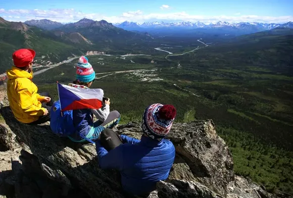
Mount Healy Overlook Trail climbs five miles round trip to views across the park entrance area, gaining elevation through spruce forest before breaking into alpine tundra. The trail stays accessible even when snow closes the Park Road deeper into the park. Savage River marks the turnaround point for private vehicles in April, offering a two-mile loop that crosses tundra where caribou migrate and wolves hunt. The park encourages off-trail hiking, creating an experience where you can literally walk in any direction rather than following marked paths. Most teenagers who visit Denali remember the freedom to explore without boundaries more than any specific viewpoint.