8 National Parks Where the Water Is the Main Event
Eight national parks where paddling isn't optional and crowds are scarce, from flooded forests to volcanic calderas
Most national parks built their reputations on what you can see from the rim or summit. These eight earned theirs from what you can reach only by paddle. They share two qualities that set them apart: water dominates the landscape, and most visitors have no idea they exist. If you're looking for kayaking and canoeing that doesn't involve fighting crowds at Lake McDonald, this is your shortlist.
April splits the difference between ice-out and peak season. You'll find manageable water levels, mild temperatures, and the kind of elbow room that vanishes by Memorial Day. Some of these parks see fewer visitors in a year than Yellowstone gets in a week.
Biscayne National Park
Ninety-five percent underwater / Miami's skyline on the horizon
You can't walk to most of Biscayne. The park protects the northernmost Florida Keys and the only living coral reef in the continental United States, which means paddling isn't optional. Launch from the mainland and you're threading mangrove tunnels on Elliott Key within an hour, watching nurse sharks glide beneath your hull in water clear enough to count their spots. Most people have never heard of this park despite its proximity to the fifth-largest metro area in the country.
Paddle far enough from shore and Miami's downtown towers shimmer like a mirage behind you while manatees surface ahead.
Boca Chita Key offers the easiest day paddle: a protected harbor, a lighthouse you can climb, and enough shallow reef to snorkel between paddle strokes. April brings calm seas before summer's thunderstorms arrive, and the water temperature hovers in the mid-seventies. Rangers run boat tours to the outer reefs if you want to save your arms, but you'll miss the mangrove labyrinths that make Biscayne feel like a different planet.
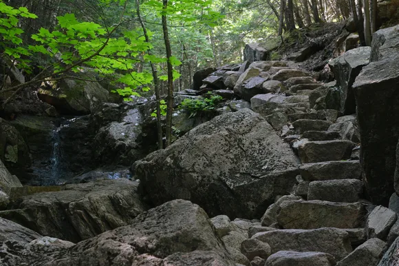
Congaree National Park
Old-growth bottomland swamp / Champion trees in a flooded forest
The Congaree River floods this South Carolina bottomland forest for weeks at a time, turning the park into a maze of paddling routes through trees that predate the Revolution. You'll glide between bald cypress trunks thick enough to hide a car, their knees jutting from blackwater channels that snake through the canopy. This is the largest intact tract of old-growth bottomland hardwood forest left in the Southeast, and almost nobody comes here. The park sees fewer visitors annually than Acadia gets in a slow week.
Paddling Congaree in April means weaving through a flooded cathedral where the ceiling is two hundred feet up and every trunk is wider than your kayak is long.
Cedar Creek offers the main paddling route: a 15-mile trail marked by white blazes on the trees. High water in April opens up side channels and oxbow lakes that disappear by summer, letting you explore deeper into the forest than the boardwalk hikers ever reach. The park loans canoes for free on weekends if you don't want to haul your own, though you'll need to reserve ahead. Bring a headlamp for the paddle back. The synchronous fireflies emerge in May, but April brings their preview show.
Channel Islands National Park
Five islands twelve miles offshore / Sea caves and kelp forests
California's answer to the Galápagos sits just off Ventura, invisible to the millions driving Highway 101. You'll need a boat to reach any of the five islands, but once you're there, the sea caves and kelp-forest channels offer some of the finest coastal paddling on the West Coast. Anacapa's sea arches let you thread passages that glow green when the sun hits right. Santa Cruz's Painted Cave stretches nearly a quarter mile into the island's cliffs, dark enough at the back to need a flashlight at noon.
Paddle through the kelp forests off Santa Cruz and harbor seals will surface so close you can hear them exhale.
April brings calm seas before the northwest wind picks up in May. The concessionaire runs kayak tours if you don't want to haul your own boat on the ferry, though they stick to the easier routes near the landings. Serious paddlers camp on Santa Cruz and spend three days exploring the north shore's caves and coves. The island fox population here evolved separately on each island, creating six distinct subspecies you won't find anywhere else. They'll raid your camp if you're not careful.
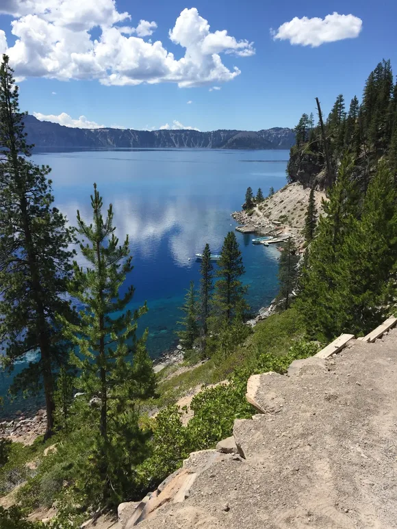
Crater Lake National Park
America's deepest lake in a volcanic caldera / Snow until July
You can't just paddle onto Crater Lake. The only water access requires hiking down the Cleetwood Cove Trail, a mile-long descent that drops 700 feet to the shore. It's the only legal boat launch in the park, which keeps the lake empty even in peak season. April means the trail is buried under 15 feet of snow, but by mid-July you can carry a kayak down and have the entire caldera to yourself. The water is so pure that scientists use it as a control sample.
Paddle to Wizard Island and the caldera walls rise around you like an amphitheater, the lake's blue so saturated it looks photoshopped.
The lake fills a volcanic crater nearly 2,000 feet deep, fed entirely by rain and snowmelt with no inlet or outlet. Water temperatures stay in the fifties even in August, cold enough that you'll want a wetsuit for any swim. Most paddlers circle Wizard Island and call it done, but if you have the stamina, the entire shoreline offers 25 miles of cliff-backed water without a single dock or development. Rangers run boat tours to the island, but they don't allow passengers to bring kayaks.
Black Canyon of the Gunnison National Park
North America's steepest gorge / Class V rapids in 2,000-foot walls
The Gunnison River carved the steepest canyon in the country through rock nearly two billion years old, creating a gorge so narrow that the sun only hits the bottom for a few minutes each day. Most visitors peer over the rim and leave, but paddlers who apply for a wilderness permit can run one of the most intimidating Class V stretches in North America. This isn't recreational kayaking. The canyon averages 240 feet of drop per mile, and rescue is measured in days, not hours.
Paddle into the Black Canyon and the walls rise so steep and tight above you that noon looks like dusk.
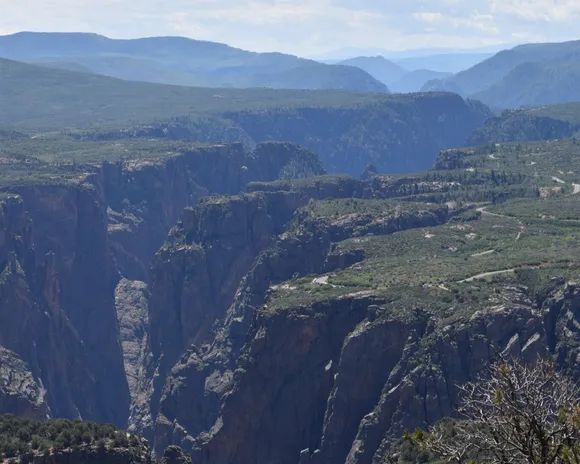
April brings runoff flows that turn the rapids from terrifying to impossible. Expert kayakers target late summer when the water drops below 1,000 cubic feet per second, though even then you're portaging some sections. The park requires proof of Class V experience and rescue capability before issuing permits. Most parties take three days to run the canyon's 14-mile wilderness section. If you're not ready for that, the stretches upstream and downstream of the park offer mellower Class II and III water with better access.
Canyonlands National Park
Four districts split by two rivers / Flatwater through canyon walls
The Colorado and Green Rivers divide Canyonlands into four districts before they meet at The Confluence, creating over 100 miles of flatwater paddling through red rock canyons as dramatic as anything on the rim. Labyrinth Canyon offers the gentlest route: 50 miles of Class I water through sandstone walls that rise 1,000 feet on both sides. You'll camp on beaches that see a dozen parties all season, watching the walls glow orange at sunset while great blue herons fish the shallows.
Paddle to The Confluence and you're sitting at the geographic heart of the Colorado Plateau with canyon walls stretching in every direction.
April brings ideal flows before the summer heat turns the canyon into a convection oven. The river runs cold from snowmelt upstream, but air temperatures reach the seventies by midday. Most parties put in at Ruby Ranch and take out at Mineral Bottom after four days of floating. You'll need to arrange a shuttle or hire an outfitter. Cataract Canyon downstream offers Class III to V rapids depending on flow, but Labyrinth stays gentle enough for loaded boats and novice paddlers.
Big Bend National Park
Mexico on one bank, Texas on the other / River canyons in the Chihuahuan Desert
The Rio Grande cuts three major canyons through Big Bend, each offering multi-day paddle trips through desert walls that rise 1,500 feet straight from the water. Santa Elena Canyon provides the classic trip: 20 miles of flatwater between limestone cliffs so narrow and tall that the light turns blue-gray at the bottom. You'll camp on river beaches in complete silence, watching the cliffs catch fire at sunset while Mexican hawks patrol the thermals overhead.
Paddle Santa Elena Canyon and the walls close in until you can't see sky, just a crack of light where the river bends ahead.
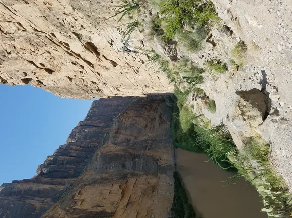
April sits at the tail end of Big Bend's peak season before the heat arrives. Daytime temperatures reach the eighties on the river, but nights drop cool enough for a sleeping bag. The park requires permits for overnight river trips and recommends going with a guide if you've never paddled desert canyons before. Boquillas Canyon offers an easier alternative: gentler gradients and wider walls with better exit points if weather turns. March draws the biggest crowds, so April gives you a better shot at solitude.
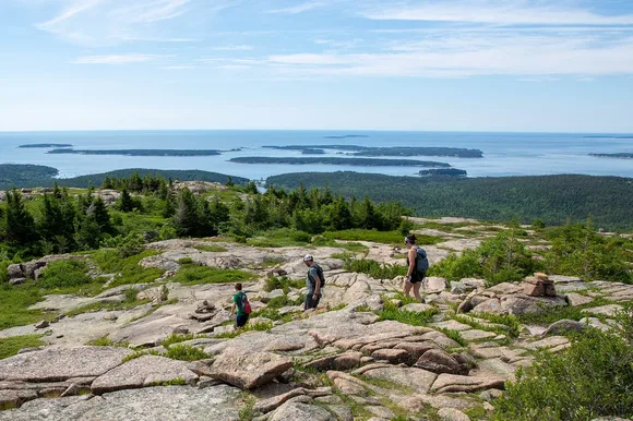
Acadia National Park
Rocky Maine coast / Packed in August, empty in April
Acadia draws more visitors than any park on this list, but almost all of them stick to the Park Loop Road and Cadillac Mountain. Launch a kayak from the town pier and you're threading granite islands and seal-packed ledges within minutes, watching lobster boats work the channels while tourists sit in traffic overhead. The park's coastline offers 40 miles of protected paddling between Mount Desert Island and the Schoodic Peninsula, with enough coves and harbors to explore for a week.
Paddle Acadia's coast at sunrise and you'll understand why people fight for parking spots: the granite glows pink, the water turns silver, and you'll have it to yourself.
April means cold water, around 42 degrees, which requires a wetsuit or drysuit for any trip longer than a quick harbor tour. But it also means empty coves and available parking, rare commodities here. The protected waters between the Porcupine Islands and Bar Harbor offer the easiest paddling, though experienced kayakers push out to Baker Island and the outer ledges when conditions allow. Several outfitters in Bar Harbor rent kayaks and run guided trips if you don't want to bring your own boat.