8 National Parks Where You Can Still See Glaciers
Eight parks where ice still carves mountains, from roadside glaciers in Alaska to Nevada's unlikely alpine surprise
Most glaciers in the Lower 48 will be gone within a generation. The ice that carved Yosemite Valley and smoothed the Adirondacks survives now only in a handful of parks, and even there it's retreating faster than scientists predicted a decade ago. But glaciers aren't just mountain decorations — they're active, calving, grinding reminders that the planet is still shaping itself.
These eight parks give you front-row access to ice that's been here longer than human civilization, paired with alpine terrain that amplifies the scale. Some glaciers you can drive to. Others require boats, bush planes, or days of off-trail navigation. April isn't prime glacier season — you'll find snow blocking high-elevation roads and trails — but it's when planning becomes essential. Most of these parks require permits, advance reservations, or logistical creativity that doesn't work as a last-minute decision.
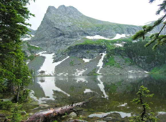
Glacier National Park
Twenty-six glaciers left from 150 / Going-to-the-Sun Road opens in June
The park's name becomes more ironic every year. When surveyors mapped this landscape in the late 1800s, ice filled every high valley. Now you need binoculars to see most of the remaining glaciers, and scientists expect them to vanish by mid-century. Grinnell Glacier Trail delivers the most accessible ice — a moderate hike to a turquoise lake where chunks of glacier calve into the water with the sound of distant thunder. The trail gains elevation steadily through bear grass meadows and past waterfalls that run cold enough to numb your hands in seconds.
You're not hiking to see a glacier so much as documenting its retreat — markers along the trail show where the ice ended in decades past.
Many Glacier Area concentrates the best glacier views without requiring technical climbing skills. Iceberg Lake sits in a cirque where ice chunks float year-round, even in August. The Park Service posts trail conditions on their website starting in May, but expect snow patches on north-facing slopes through June. Going-to-the-Sun Road typically opens in mid-June, and once it does, Logan Pass becomes the most efficient glacier-spotting location — Jackson Glacier sits close enough to see crevasses without leaving the pavement.
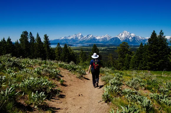
Grand Teton National Park
Seven thousand feet of vertical relief / Glaciers visible from the valley floor
The Tetons rise without the courtesy of foothills, which means you can see glaciers from your car if you know where to look. Teton Glacier sits in a north-facing bowl on the Grand's flank, visible from multiple pullouts along Teton Park Road. Middle Teton Glacier appears smaller but more accessible — though "accessible" is relative when it requires scrambling over talus fields at elevation. Cascade Canyon Trail brings you within striking distance of several small glaciers, though most hikers turn around at Lake Solitude without pushing higher.
The Tetons prove that you don't need a vast icefield to feel humbled — just granite that refuses to apologize for its verticality.
Schoolroom Glacier earned its name because professors use it to teach glaciology students what active ice looks like. It moves, carves, and calves in ways that cameras capture better than words. Most of the park's glaciers require technical climbing to reach, but Jenny Lake provides perspective on how ice shaped this valley. The lake itself sits in a glacial trough, and the moraine that dams its southern end shows how far the ice once extended. Rangers lead geology walks in summer that explain the mechanics of glacial carving better than any guidebook.
Kenai Fjords National Park
Exit Glacier by road / Harding Icefield by effort
Exit Glacier earns its reputation as Alaska's most approachable ice. You can walk from the parking lot to the glacier's face in under a mile, passing markers that show where the terminus stood in previous decades. The retreat becomes visceral when you realize the 1950 marker sits nearly a mile behind the current ice. Harding Icefield Trail climbs above the glacier to reveal what feeds it — a frozen plateau that covers over 700 square miles and spawns dozens of glaciers that flow toward the coast.
Standing on Harding Icefield feels like stepping onto another planet — white in every direction, with only the occasional nunatak breaking through.
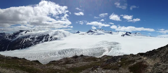
The icefield hike gains over 3,000 feet in just over four miles, which sounds manageable until you factor in mud, snow patches, and weather that changes faster than you can adjust layers. Most hikers turn around before reaching the icefield proper, settling for views of Exit Glacier from above. Boat tours from Seward offer a different perspective — tidewater glaciers that calve directly into the ocean, sending waves across the fjords that rock even large vessels. Northwestern Glacier produces the most dramatic calvings, though timing is unpredictable.
Glacier Bay National Park & Preserve
Fifteen tidewater glaciers / Reachable only by boat or plane
Glacier Bay didn't exist as open water when George Vancouver mapped the area in 1794 — ice filled the entire bay. Now that ice has retreated over 65 miles, leaving a fjord system where glaciers calve into saltwater and humpback whales feed within camera range. Most visitors arrive on cruise ships, which dominate the peak summer season, but smaller tour boats from Bartlett Cove offer closer access without the crowds. Margerie Glacier reaches the water as a wall over 200 feet tall, and when sections calve, the sound echoes off the surrounding peaks like artillery.
Tidewater glaciers don't retreat quietly — they thunder into the ocean with enough force to generate waves that travel for miles.
Johns Hopkins Glacier closes the upper inlet with ice that remains over a mile wide at its terminus. Harbor seals pup on the floating ice in late spring, which means the Park Service restricts boat access during pupping season. Bartlett Cove serves as the only developed area, with a ranger station, lodge, and the short Forest Loop Trail that introduces you to temperate rainforest ecology. Kayakers willing to arrange drop-off service can paddle the bay's arms for days, camping on beaches where brown bears fish for salmon.
Gates of the Arctic National Park & Preserve
Zero roads, zero trails / Brooks Range glaciers in true wilderness
Fewer people visit Gates of the Arctic each year than Yellowstone sees in an average afternoon. The Brooks Range holds glaciers that most Americans don't know exist, and reaching them requires chartering a bush plane or hiking for days through tundra that doesn't bother with trails. Arrigetch Peaks rise above the Alatna River valley with glaciers clinging to north-facing cirques, visible only if you're willing to navigate without markers or maintained paths.
This park doesn't accommodate visitors — it tolerates them, and only barely.
Frigid Crags lives up to its name, holding ice in valleys where summer temperatures never climb high enough to melt the snowpack completely. Off-trail backpacking here means crossing rivers without bridges, navigating by topographic map and compass, and carrying bear spray for grizzlies that don't associate humans with food. Most visitors fly into the park, backpack for a week, and fly out without seeing another person. Alpine glaciers feed rivers that caribou cross during migrations that have followed the same routes for millennia.
Great Basin National Park
Nevada's only glacier / Wheeler Peak at 13,000 feet
The idea of a glacier in Nevada sounds implausible until you climb Wheeler Peak and find ice tucked into a cirque below the summit. Wheeler Peak Glacier holds the distinction of being the only permanent ice in the state, though "permanent" requires an asterisk — it's shrinking, and scientists debate whether it qualifies as a true glacier or just a stubborn ice field. The distinction matters to glaciologists but not to hikers who reach the overlook and see blue ice where logic says none should exist.
Great Basin proves that glaciers don't need Alaska's latitude — just elevation, shade, and enough winter snow to outlast summer melt.
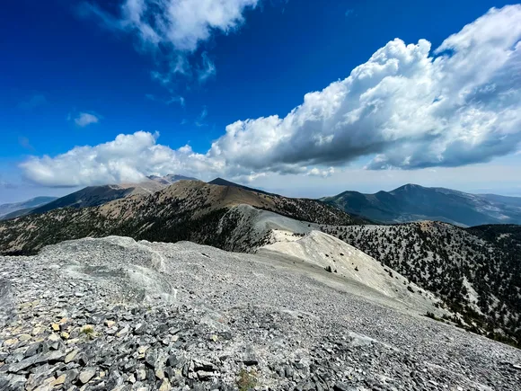
Wheeler Peak Trail climbs through bristlecone pine forests where trees older than the pyramids grow twisted and gnarled by high-altitude winds. The final push to the glacier overlook gains elevation fast, and the air thins enough to slow your pace whether you want it to or not. Most visitors never make it this far — they tour Lehman Caves, drive the scenic road, and leave without realizing alpine terrain sits above. The park stays uncrowded even in summer, and September offers the best combination of clear weather and solitude.
Great Sand Dunes National Park & Preserve
Dunes below, glacial lakes above / Vertical diversity in a single park
Most people don't realize that Great Sand Dunes includes alpine terrain that reaches above 13,000 feet. The Sangre de Cristo Mountains rise directly behind the dune field, and their high valleys hold small glaciers and permanent snowfields that feed Medano Creek. Music Pass Trail climbs past tree line into a landscape of tundra and rock where glaciers carved cirques that still hold ice in shaded pockets.
You can stand on a sand dune at 8,000 feet and look up at glacial ice without changing your position — geography that shouldn't work but does.
The glaciers here don't announce themselves like those in Alaska or Montana. They hide in north-facing bowls, visible only to hikers willing to push past the treeline and scramble over talus. Alpine lakes formed by glacial melt sit cold and clear at elevations where summer lasts barely three months. Mosca Pass Trail offers easier access to alpine terrain without requiring technical skills, though snow lingers on the pass through June. The park's vertical relief — from dune field to summit — exceeds 5,000 feet, and the climate zones shift accordingly.
Haleakalā National Park
Volcanic crater at 10,000 feet / Ice Age glaciers shaped the summit
Haleakalā doesn't hold glaciers now, but the crater's shape reveals their past presence. During the last ice age, glaciers formed on the volcano's summit, carving the bowl that visitors see today. The alpine environment above 10,000 feet creates conditions cold enough for frost year-round, and snow dusts the crater several times each winter. Sliding Sands Trail descends into the crater through cinder cones and volcanic rock that looks more like Mars than Hawaii.
The summit air feels thin and cold enough to remind you that alpine doesn't require continents — just altitude and persistence.
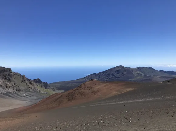
While Haleakalā lacks active glaciers, its volcanic terrain and alpine climate create an ecosystem found nowhere else. Silversword plants grow only here, adapted to freezing nights and intense solar radiation at elevations where most vegetation surrenders. The crater stretches for miles, and backpackers can camp on its floor surrounded by cinder cones that glow red at sunrise. Rangers explain how glacial ice once filled the summit basin, shaping the landscape before the volcano's last eruptive period.