8 national parks with the most paved trails
From Acadia's carriage roads to Yellowstone's geothermal boardwalks, these parks prove accessibility doesn't mean sacrificing scenery
Most national park trails demand compromise. You trade accessibility for scenery, distance for solitude, or you simply skip the trail altogether because mobility limits what's possible. But paved trails eliminate that calculus. They're not just for wheelchairs and strollers — they're for anyone who wants to experience a waterfall, a glacial lake, or a granite summit without navigating roots, rocks, and mud.
These eight parks have invested in paved trail networks that range from short waterfall walks to twenty-mile former canal paths. Some parks paved historic carriage roads built by Rockefeller money. Others converted railbeds and towpaths into bike routes that traverse entire valleys. The result is a collection of parks where accessibility doesn't mean sacrificing the views.
Acadia National Park
45 miles of car-free carriage roads / Draws more visitors than Phoenix
John D. Rockefeller Jr. spent two decades building 45 miles of crushed-stone carriage roads through Acadia, and the park has maintained them as motor-free routes ever since. The roads loop past Jordan Pond, wind through forests that explode with fall color, and climb to overlooks that frame the Atlantic against granite peaks. You can walk them, bike them, or ride a horse-drawn carriage along the same routes that Gilded Age families used to escape Bar Harbor's summer heat.
The carriage roads feel like a secret even when they're packed — the forest canopy muffles the crowds, and every quarter mile brings another stone bridge worth photographing.
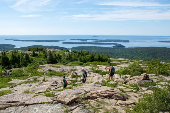
The Jordan Pond Shore Trail is fully paved and circles one of the park's most photographed bodies of water. The loop takes an hour at a leisurely pace, and the views of the Bubbles — two round granite peaks — are the reason half the postcards from Acadia look identical. The park gets packed in August and October, but May offers mild temperatures in the 60s and 70s, blooming wildflowers, and parking spots that don't require a 6 AM arrival.
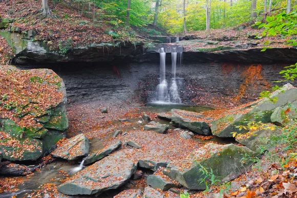
Cuyahoga Valley National Park
20-mile towpath along the Ohio & Erie Canal / Midway between Cleveland and Akron
The Towpath Trail follows the route that mules once walked while towing canal boats between Lake Erie and the Ohio River. Today it's a flat, paved ribbon that runs through the heart of the park, past restored canal locks, wetlands thick with herons, and the 65-foot drop of Brandywine Falls. The trail connects to the Ohio & Erie Canal Towpath Trail system, which eventually stretches over 100 miles from Cleveland to New Philadelphia.
This is the rare national park where you can bike 20 miles without gaining more than 100 feet of elevation — the canal builders made sure of that.
Cuyahoga Valley doesn't have the drama of western parks, but it offers something harder to find: easy access to nature from a major metro area. The park sits 25 miles from downtown Cleveland, and the Towpath Trail connects directly to the Cuyahoga Valley Scenic Railroad, which offers bike-and-ride options for one-way trips. Brandywine Falls has its own short paved trail with boardwalks that get you to the overlook in under ten minutes.
Yosemite National Park
12 miles of paved valley paths / Three times the size of New York City
Yosemite Valley has a network of paved bike paths and walking trails that connect campgrounds, lodges, trailheads, and shuttle stops without requiring a car. The paths run along the Merced River, pass through meadows where El Capitan fills the skyline, and loop around Mirror Lake when spring runoff fills the basin. The valley floor sits at 4,000 feet, which means you can hike to the base of Yosemite Falls or Bridalveil Fall on pavement that never requires scrambling over talus.
The paved paths let you experience the valley the way Ansel Adams saw it — from the meadows, looking up at granite walls that vanish into clouds.

The Lower Yosemite Fall Trail is fully paved and takes you to the base of North America's tallest waterfall, where spring melt sends spray 50 feet into the air. By July the falls slow to a trickle, but May brings peak flow and wildflowers that blanket the valley meadows. The park gets crowded, but the valley's size absorbs the crowds better than most national park destinations.
Glacier National Park
Going-to-the-Sun Road crosses the Continental Divide / Twice the size of Rhode Island
Going-to-the-Sun Road is the main attraction, and while it's not a trail, the park has paved several key sections for pedestrian use, including the Trail of the Cedars and the boardwalks around Logan Pass. The Trail of the Cedars is a short loop through old-growth forest that connects to the unpaved Avalanche Lake Trail. The boardwalks at Logan Pass protect the fragile alpine tundra while letting visitors walk above treeline without damaging the ecosystem.
Logan Pass sits at 6,646 feet, and the paved boardwalks put you at eye level with mountain goats that treat tourists like furniture.
The park opens Going-to-the-Sun Road in late June or early July, depending on snowpack. Until then, you can bike the unplowed sections from either side, which gives you car-free access to some of the most dramatic alpine scenery in the Lower 48. The Hidden Lake Overlook Trail starts on a paved path from Logan Pass before transitioning to boardwalks and eventually dirt as it climbs toward the overlook.
Great Smoky Mountains National Park
Laurel Falls paved trail climbs 400 feet / More visitors than any other national park
The Laurel Falls Trail is the park's most popular paved path, a two-and-a-half-mile round trip that switchbacks through hardwood forest to an 80-foot waterfall split by a rocky outcrop. The trail gets shoulder-to-shoulder busy on weekends, especially during spring wildflower season and fall color, but it's one of the few places in the Smokies where you can reach a major waterfall without rock-hopping across streams or climbing over fallen logs.
The Smokies receive more annual visitors than the entire population of Los Angeles, and Laurel Falls absorbs a significant percentage of them.

The park has also paved sections of the Gatlinburg Trail and the Oconaluftee River Trail, both of which allow leashed dogs — a rarity in national parks. The Oconaluftee River Trail runs flat along the river for three miles, connecting the visitor center to the Mountain Farm Museum, where historic log buildings show what Appalachian farm life looked like before the park was established in 1934.
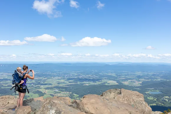
Shenandoah National Park
Skyline Drive runs 105 miles of ridge crests / 75 miles from the Capitol
Shenandoah's paved trails are short but strategically placed at popular overlooks along Skyline Drive. The Limberlost Trail is a fully accessible loop through a hemlock forest that was once slated for logging before becoming part of the park. The crushed greenstone surface is smooth enough for wheelchairs, and the forest canopy stays cool even when August temperatures climb into the 80s.
Limberlost feels like a secret even though it's advertised in every visitor center — the forest swallows sound, and most visitors speed past it on their way to more famous overlooks.
Dark Hollow Falls Trail is paved for the first half mile before transitioning to stone steps as it drops toward the 70-foot waterfall. It's one of the park's most popular short hikes, and the pavement makes the first section accessible for families with young kids or anyone testing their limits before committing to steeper terrain. Shenandoah's proximity to Washington, D.C., means weekends can feel like a suburban trail system, but May brings blooming wildflowers and manageable crowds.
Rocky Mountain National Park
Bear Lake loop circles a glacial tarn / Trail Ridge Road tops out above 12,000 feet
The Bear Lake loop is a half-mile paved path around one of the park's signature alpine lakes, surrounded by lodgepole pines and backed by the Continental Divide. It's the most popular easy trail in the park, which means the parking lot fills by 7 AM on summer mornings. From Bear Lake, you can branch off onto longer unpaved trails that climb to Emerald Lake or Hallett Peak, but the paved loop delivers Rocky Mountain scenery without elevation gain.
Bear Lake sits at 9,475 feet, and the thin air reminds sea-level visitors that altitude matters — even on a flat, paved path.
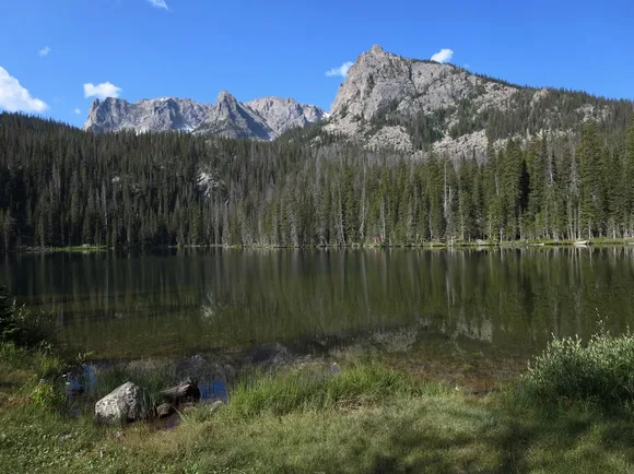
Sprague Lake has a similar paved loop that's slightly longer and less crowded, with views of the peaks above Glacier Gorge. The park also paved sections of the Glacier Basin area to create accessible fishing platforms and picnic areas. Rocky Mountain implemented a timed entry permit system for peak season, so you'll need to reserve a slot in advance if you're visiting between May and October.
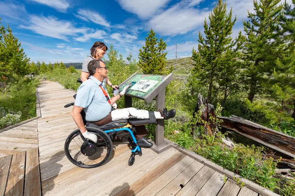
Yellowstone National Park
Boardwalks circle thermal features / Larger than Delaware and Rhode Island combined
Yellowstone's boardwalks aren't technically trails, but they're how you experience the geysers, hot springs, and mudpots that define the park. The Upper Geyser Basin boardwalk runs over a mile and connects Old Faithful to Morning Glory Pool, passing dozens of thermal features that erupt, steam, or bubble on unpredictable schedules. The Grand Prismatic Spring overlook boardwalk climbs a short hill to a viewing platform above the largest hot spring in the United States, where the water shifts from deep blue to orange and yellow depending on the thermophilic bacteria thriving at different temperatures.
You don't walk Yellowstone's boardwalks so much as float above them — the smell of sulfur, the sound of boiling water, and the knowledge that the ground could collapse into superheated pools keeps you alert.
The park's size absorbs crowds better than almost any national park, and even in July you can find stretches of boardwalk with elbow room. The West Thumb Geyser Basin boardwalk loops along the shore of Yellowstone Lake, where thermal features bubble up through the water like underwater geysers. May is early for Yellowstone — snow often lingers at higher elevations — but the lower basins open by mid-month, and you'll trade some road closures for bison calves and fewer tour buses.