8 National Parks With the Most Trails
Eight parks where trail networks measure in hundreds of miles and you could hike every weekend for years without repeating routes
Most national parks offer a dozen notable trails and a handful of backcountry routes. The eight parks on this list operate at a different scale entirely: networks so vast they measure in the hundreds of miles, where you could hike every weekend for a decade and still find new ground. These aren't just parks with trails. They're trail systems that happen to have park boundaries around them.
In April, when winter eases but summer crowds haven't arrived, these trail networks come into their own. Snow still blocks high passes in the Rockies and Cascades, but lower elevations open up, waterfalls run at full volume, and wildflowers carpet the valleys. You'll find elbow room even in parks that see millions of visitors.
Yellowstone National Park
More trail miles than most states have highways / Bigger than Delaware and Rhode Island combined
Yellowstone's trail network could swallow most eastern parks whole. The park has more maintained trail than Connecticut has state routes, and most visitors never leave the boardwalks around Old Faithful. That gap between where tourists congregate and where the trails actually go is one of the best-kept secrets in a park that invented the concept of mass tourism. Walk just two miles past any parking lot and you'll have the place to yourself, even in July.
The boardwalks see shoulder-to-shoulder traffic while trails a mile away sit empty all day.
The Grand Prismatic Spring Overlook and Lamar Valley trails deliver the postcard views without the thermal basin crowds. For something longer, Mount Washburn gains elevation through open meadows where bighorn sheep graze above the tree line. April means lower elevation trails only, but that includes the Grand Canyon of the Yellowstone's South Rim Trail, where snowmelt turns the Yellowstone River into a thundering cascade twice its summer volume. The park's sheer size absorbs visitors the way its caldera absorbed ancient lava flows.
Great Smoky Mountains National Park
As many trail miles as annual visitors in Los Angeles / Peak season crowds every parking lot
The Smokies draw more visitors than any other national park, which makes its trail system critical infrastructure rather than optional recreation. Laurel Falls Trail packs in families by the hundreds, but step onto the Rainbow Falls or Abrams Falls trails and the density drops to sustainable levels. The park has enough trail to disperse crowds that would overwhelm smaller preserves, though April weekends still test that capacity.
Cades Cove might be bumper-to-bumper, but the trails radiating from it see a fraction of the traffic.
Alum Cave Trail to Mount LeConte climbs through rhododendron tunnels and past rock shelters worn smooth by hikers seeking shelter for over a century. The eleven-mile round trip gains enough elevation to leave casual tourists behind by mile two. April brings wildflower blooms to lower elevations while higher trails shed their winter ice. Chimney Tops reopened after wildfire restoration, and the crowds followed, but the dozens of moderate trails threading through the park's interior remain surprisingly uncrowded given the parking lot chaos.
Yosemite National Park
Three-quarters as many trail miles as the Smokies in two-thirds the crowds / Valley floor sees the masses
Yosemite's trail system radiates from a seven-square-mile valley that hosts the majority of park visitors. Half Dome and Yosemite Falls trails funnel thousands of hikers through permit systems and lottery queues, but trails in Tuolumne Meadows and Hetch Hetchy see manageable traffic even at peak season. April means valley trails only since Tioga Road stays closed until late May, but that's when waterfalls perform their best work.
Yosemite Falls drops with enough force in April that you feel the mist from the parking lot a quarter mile away.
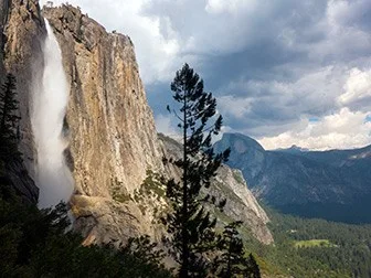
The Mist Trail to Vernal Fall lives up to its name when snowmelt turns the Merced River into a fire hose. You'll climb granite steps slick with spray while the falls roar close enough to drown out conversation. Mirror Lake Loop offers easier terrain through meadows where wildflowers bloom against the backdrop of Half Dome's north face. The Mariposa Grove trails wind through giant sequoias that make the surrounding sugar pines look like saplings. Rangers lead walks that explain how these trees survive fires that would level ordinary forests.
Glacier National Park
Trail miles matching its namesakes / Going-to-the-Sun Road opens by mid-June most years
Glacier's trail network connects valley floors to alpine lakes carved by ice that's still retreating. The park maintains enough trail that you could walk from Canada to the southern boundary without repeating a route, passing through ecosystems that range from cedar groves to tundra where pikas harvest wildflowers for winter storage. April keeps you at lower elevations, but that means better odds of spotting grizzlies emerging from hibernation in the valleys.
Twenty-six glaciers remain from the 150 that shaped these valleys, and the trails document what's melting away.
Hidden Lake Overlook climbs from Logan Pass through meadows that erupt with beargrass blooms by July, but April snow keeps the pass closed. Instead, hike the Belly River Trail to Poia Lake from the eastern entrance, where lower elevations mean earlier access and fewer people than the park's famous west-side trails. Grinnell Glacier Trail shows you the ice up close when it opens later in spring, following a route that passes turquoise lakes fed by glacial melt. The trail system here rewards patience. Most lakes stay frozen until June, but early season means mountain goats on the trails and no permit battles for campsites.
Grand Canyon National Park
As many trail miles as Yosemite packed into a canyon a mile deep / South Rim open year-round
The Grand Canyon's trail system measures distance in vertical feet as much as horizontal miles. Rim trails stay flat and crowded, but drop below the rim and you'll find solitude at every switchback. The park maintains trails that descend through rock layers spanning two billion years of geology, from Kaibab limestone at the rim to Vishnu schist at the river that's older than multicellular life.
Every thousand feet down equals a climate zone shift, desert scrub giving way to riparian cottonwoods that wouldn't survive on the rim.
Bright Angel Trail drops through side canyons where springs create micro-oases of ferns and columbine. Most day hikers turn around at the three-mile rest house, which means you'll have the trail increasingly to yourself if you continue to Indian Garden. South Kaibab Trail offers bigger views with no water sources, a trade-off that keeps crowds thinner than Bright Angel despite the superior panoramas. April temperatures make rim-to-river hiking survivable where summer heat turns the inner canyon into a convection oven. The Rim Trail connects viewpoints for thirteen miles without gaining elevation, perfect for families who want canyon views without the knee-punishing descent.
Olympic National Park
Rainforest, glacier peaks, and wild coast connected by more trail than most parks attempt / Three ecosystems in one park
Olympic packs more ecological diversity into its trail system than seems physically possible. You can hike temperate rainforest where moss hangs from Sitka spruce, climb through alpine meadows to glaciers on Mount Olympus, and camp on beaches where sea stacks rise from tide pools—all without leaving park boundaries. The trail network stitches these zones together through valleys that see two hundred inches of rain annually in some spots and twenty inches in others.
The Hoh River Trail passes through rainforest so dense that noon light filters green through the canopy.
Marymere Falls Trail delivers a ninety-foot waterfall through old-growth forest in less than two miles, perfect for April when snowmelt swells the creek. The Ozette Triangle connects beach hiking with boardwalk forest trail, passing petroglyphs worn smooth by centuries of Pacific storms. Mount Olympus Trail requires backpacking permits and river crossings, but lower sections through the Hoh rainforest stay accessible year-round. April means the coast trails see fewer visitors than summer while waterfalls run at full volume. Rangers at the Hoh visitor center can steer you toward trails that match your tolerance for mud.
Rocky Mountain National Park
Three hundred trail miles in less space than Olympic / Trail Ridge Road reaches higher than most mountains
Rocky Mountain compresses more trail into less area than seems sustainable, which explains why the park requires timed entry permits during summer. The trail network connects alpine lakes to Continental Divide passes, threading through terrain that stays above tree line for miles at a stretch. April keeps high elevation trails under snow, but Bear Lake basin trails open early and concentrate enough scenery into short distances that you'll understand why this place sees crowds.
Dream Lake reflects Hallett Peak so perfectly that hikers spend more time photographing the reflection than the mountain itself.
The Bear Lake Loop delivers alpine lake views in half a mile, which makes it popular with families who want national park scenery without the elevation gain. Emerald Lake Trail extends the route through three lakes, each more dramatic than the last. Sky Pond Trail climbs to tarns tucked beneath the Divide, passing Alberta Falls where water drops in tiers through granite chutes. Longs Peak Trail stays snowbound until July most years, but lower trails like Glacier Gorge open by late April when wildflowers carpet the meadows. The park's proximity to Denver means weekend traffic, but sunrise hikes beat the crowds arriving from the Front Range.
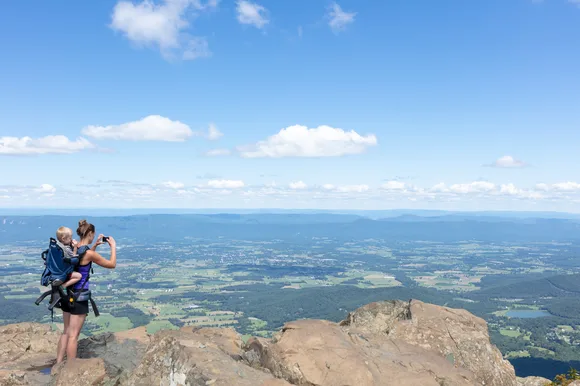
Shenandoah National Park
Five hundred trail miles along the Blue Ridge / Skyline Drive traces the spine for 105 miles
Shenandoah's trail system follows the Blue Ridge through terrain that was farmland a century ago. Stone walls mark old property lines, and apple trees planted by homesteaders still fruit in clearings where cabins once stood. The park maintains enough trail that you can walk the entire length without touching Skyline Drive, though most hikers sample sections between overlooks rather than committing to the full route.
Old Rag Mountain demands scrambling through boulder fields where you'll use hands as much as feet to reach the summit.
Dark Hollow Falls drops eighty feet through forest that greens up by April, the shortest route to a waterfall in the park. Hawksbill Summit Trail climbs to the park's highest point through terrain that stays manageable for families despite the elevation gain. Old Rag requires reservations even on weekdays, a lottery system implemented after hikers literally formed traffic jams on the rock scramble. Limberlost Trail offers wheelchair-accessible forest walking through groves where hemlocks shade streams cold enough for native brook trout. April means wildflower season without the October leaf-peeper crowds that turn Skyline Drive into a parking lot. The park's proximity to Washington makes it a weekend escape for millions, but the trail system disperses hikers efficiently once they leave the overlooks.