8 parks perfect for seniors in spring
Eight national parks where paved paths, carriage roads, and drive-up overlooks deliver scenery without the scramble
April offers seniors what summer crowds and peak season prices take away: accessible landscapes, comfortable walking temperatures, and the breathing room to experience a national park at your own pace. The parks below prioritize paved paths, flat trails, and drive-up access to major features without sacrificing scenery or substance.
You won't find wilderness epics requiring knee-destroying scrambles or multi-day backcountry permits. Instead, you'll find bathhouses where you can soak after a morning walk, carriage roads designed before cars existed, and cave tours where guides do the navigating while you focus on formations older than human language.
Hot Springs National Park
Historic bathhouses meet thermal springs / Fifty miles from Little Rock
Hot Springs built an entire town around the idea that soaking in naturally heated water could cure what ails you. The science behind those turn-of-the-century health claims remains questionable, but the infrastructure they left behind is exceptional. Bathhouse Row lines Central Avenue with eight buildings dating from the 1910s and 1920s, and two still offer thermal baths where you can book hour-long soaks in water that emerges from the ground at temperatures most people use for brewing coffee.
You can walk the entire Promenade behind Bathhouse Row without gaining more than twenty feet of elevation.

The park's trail system climbs into the Ouachita Mountains, but you don't need to tackle those routes to experience what makes this place distinct. The flat, paved paths around the historic district pass drinking fountains dispensing thermal water, interpretive signs explaining the gangster era, and benches positioned for people-watching. April temperatures sit comfortably in the seventies, before summer humidity turns the town into a steam bath of its own.
Acadia National Park
Carriage roads wind past granite peaks and Atlantic surf / Portland is two hours south
John D. Rockefeller Jr. spent decades and millions building a network of carriage roads through Acadia specifically to keep automobiles out of the landscape. That early-twentieth-century exclusion creates twenty-first-century accessibility. The carriage roads run flat or gently graded for forty-five miles, wide enough for wheelchairs and walkers, surfaced with crushed stone that packs firm underfoot. Jordan Pond Shore Trail follows the carriage road around water so clear you can watch trout holding in the shallows while the Bubbles rise behind you.
The carriage roads give you mountain scenery without mountain climbing.
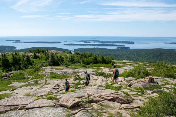
April means you'll miss the August crowds that turn Park Loop Road into a parking lot, but you'll also gamble with weather. Coastal Maine swings between fifty-degree sunshine and forty-degree fog with little warning. Layer accordingly, and know that the Island Explorer shuttle bus doesn't start running until late June. That means you'll need your own vehicle or patience with limited parking at popular trailheads. Jordan Pond House serves popovers on the lawn overlooking the water, and the ritual afternoon tea feels entirely appropriate after a morning walk.
Cuyahoga Valley National Park
Twenty miles of flat canal towpath / Cleveland's backyard
The Ohio & Erie Canal Towpath follows the Cuyahoga River through forest that once carried commercial barges pulled by mules. That history translated into infrastructure that works beautifully for anyone who prefers level ground. The crushed limestone path runs pancake-flat for its entire length, wide enough for side-by-side walking, accessible for wheelchairs and mobility scooters. You can walk a quarter mile or twenty miles depending on your stamina, with parking access every few miles if you want to sample sections rather than commit to the full route.
Brandywine Falls drops sixty-five feet over shale ledges just steps from a boardwalk that eliminates the need for scrambling.

April brings wildflowers to the forest floor before the canopy leafs out enough to shade them. Bloodroot and trillium push through last year's leaves while wood ducks stake out nest boxes along the wetlands. The park sits close enough to Cleveland that you can drive out for a morning walk and still make dinner reservations in Ohio City. No entrance fee, no campground reservations required, no wilderness permit complications.
Shenandoah National Park
Skyline Drive runs 105 miles along the Blue Ridge crest / Seventy-five miles from D.C.
Shenandoah offers what many western parks cannot: you can see most of its signature landscapes without leaving your car. Skyline Drive climbs to ridgeline overlooks where the Shenandoah Valley stretches west and the Piedmont rolls east, all accessible via paved pullouts with minimal walking. Dark Hollow Falls requires only seven-tenths of a mile each way, though the return trip climbs back up what you descended. Limberlost Trail runs flat for over a mile through old-growth hemlock on a crushed greenstone surface designed for universal access.
April means redbud and dogwood blooming in the hollows while the ridge tops still show bare branches against the sky.

The park maintains four lodges with dining rooms, which matters when you're planning multi-day visits without wanting to cook over a camp stove. Big Meadows Lodge sits at mile marker fifty-one with rocking chairs on the veranda and breakfast service that starts early enough to catch sunrise. Deer wander the meadow at dusk while guests watch from the comfort of Adirondack chairs. April temperatures hover in the sixties during the day, cool enough for comfortable walking but warm enough that you won't need winter layers.
Mammoth Cave National Park
The world's longest cave system / Ninety miles from Louisville
Rangers lead every tour at Mammoth Cave, which means you're never navigating alone through passages that have confused explorers for two centuries. The Historic Tour covers two miles underground over two hours, all of it on paved paths with handrails where the route requires them. You'll see Gothic Avenue's forty-foot ceilings, Mammoth Dome's vertical shaft, and passages where enslaved guide Stephen Bishop led tours in the 1830s. The cave maintains fifty-four degrees year-round, which in April means bringing a jacket for the temperature drop from surface conditions.
You descend into geology so old that the formations predate every park feature you've ever photographed above ground.
The Frozen Niagara Tour prioritizes formations over history, spending ninety minutes among flowstone cascades and draperies that look like melted wax. Both tours involve stairs, but the park offers the Accessible Tour specifically designed for visitors using wheelchairs or who cannot manage standard staircases. Above ground, the Green River Bluffs Trail runs mostly level for three and a half miles through forest recovering from decades of farming before the park acquired the land. April temperatures make surface hiking pleasant before summer humidity turns Kentucky thick as soup.
Gateway Arch National Park
Smaller than many suburban lots / Downtown St. Louis
Gateway Arch National Park fits into less ground than a shopping mall parking lot, which makes it manageable when sprawling landscapes feel overwhelming. The grounds include paved paths along the Mississippi River, the Museum of Westward Expansion beneath the Arch, and tram rides to the observation deck at the top of Eero Saarinen's stainless steel monument. That observation deck sits as high as a sixty-story building, accessed via a tram system that feels like riding inside a clothes dryer, but the views span Illinois to the east and Missouri to the west.
You can experience the entire park in half a day and still have time for toasted ravioli in The Hill neighborhood.

April weather in St. Louis swings unpredictably between winter remnants and summer previews. Pack layers and check forecasts obsessively. The park connects to downtown hotels via sidewalks, which eliminates driving complications if you're staying within walking distance. Security screening to enter the Arch resembles airport protocols, so leave pocket knives and large bags at your hotel. The Old Courthouse two blocks west offers free admission and fewer crowds, with exhibits on the Dred Scott case and westward expansion that provide context the Arch itself cannot communicate through architecture alone.
Petrified Forest National Park
Twenty-eight miles of scenic road through painted badlands / Most people have never heard of it
Petrified Forest delivers scenery from your car window that rivals anything you'd hike to in parks ten times its size. The park road connects overlooks where you can pull off, walk fifty feet, and photograph petrified logs wider than compact cars scattered across technicolor mudstone. Blue Mesa Trail drops into badlands via a paved loop just over a mile long, descending through layers of purple and gray bentonite that eroded into hills resembling half-melted clay. The elevation change totals less than two hundred feet, and the trail surface stays smooth enough for careful footing in walking shoes.
Trees that fell 225 million years ago now sprawl across the desert turned to stone and polished by wind into something closer to jewelry than lumber.
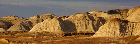
April means wildflowers if winter rains were generous, with penstemon and globe mallow adding actual color to a landscape already saturated with pigment. The park sits far from major cities, which keeps crowds manageable even during what passes for peak season elsewhere. You'll drive Interstate 40 east from Flagstaff or west from Albuquerque, both routes taking close to two hours. That distance discourages day-trippers, leaving the park to people who planned specifically to come here rather than stumbling in from somewhere more famous.
Badlands National Park
Lunar spires weathering from ancient fossil beds / Sixty miles from Rapid City
Badlands Loop Road runs thirty miles through the North Unit with overlooks positioned every few miles where you can pull off and stare at geology that looks computer-generated. The formations rise in tight clusters of spires and walls eroded from sediment laid down when this landscape sat beneath shallow seas. Door Trail leads a quarter mile from the parking lot to a boardwalk where you can walk into the formations rather than photographing them from a distance. The trail stays level, the surface firm, and the scenery delivers what the park promises without requiring backcountry permits or scrambling skills.
The Badlands weather vertically, exposing 75 million years of earth history in striped walls that document everything from ancient seas to Ice Age mammals.
April temperatures sit comfortably in the sixties before summer heat turns the shadeless badlands punishing. Bison wander through the grasslands along Sage Creek Rim Road, and bighorn sheep claim the crumbling slopes near Pinnacles Overlook. The park maintains Cedar Pass Lodge with cabins and a restaurant, which matters when the nearest substantial town sits an hour away. Wildlife watching requires nothing more than pulling over and waiting with patience and binoculars while animals move through their territories on schedules that ignore tourist convenience.