8 Parks Where Kids Can Hike Every Trail
Eight national parks where the entire trail system stays short and gentle enough for elementary schoolers to complete
Most national parks dare families to push harder, climb higher, earn their views. These eight take a different approach: every trail they offer is short enough and gentle enough for elementary schoolers to complete. Not just the nature walks or the boardwalks, but the entire trail system. You could hike them all in a long weekend, and your six-year-old would still have energy for the hotel pool.
April brings the sweet spot across most of these parks: wildflowers in the deserts, snowmelt filling creeks, temperatures mild enough that nobody's complaining. The crowds haven't peaked yet, and the trails stay accessible without feeling conquered.
Biscayne National Park
Six trails, eight miles total / Miami's skyline on the horizon
This park operates by water rules. The trails don't wind through forests or climb ridgelines. They trace Elliott Key's coral limestone spine and loop around Boca Chita's lighthouse, all flat enough that your attention stays on the mangroves and the turquoise shallows rather than your footing. Most people have never heard of Biscayne, despite sitting fifteen miles from Miami. That's because the real park lives underwater, where the continental United States' only living coral reef system sprawls across shallow flats you can snorkel without a boat.
You'll watch cruise ships glide past while standing knee-deep in a reef older than the city behind you.
The Elliott Key Trail runs two miles through hardwood hammock, an easy walk that delivers a genuine subtropical forest experience without the sweat equity most Florida trails demand. Kids can spot hermit crabs, land crabs the size of softballs, and if you time it right in April, migratory warblers moving north. The Boca Chita Lighthouse Trail takes half a mile to circle the island, with shallow swimming spots perfect for families who want to cool off without fighting surf.
Carlsbad Caverns National Park
Twelve trails, most underground / Bats spiral out at dusk
The Big Room Tour takes barely over a mile of paved, lit pathway through a limestone chamber so vast it could swallow six football fields. You're walking through a cavern carved by sulfuric acid rather than water, which explains the strange formations that look nothing like the drip-castle stalactites you'd expect. Kids handle the underground distance without complaint because the scenery changes every hundred feet: curtains of rock, forests of stalagmites, bottomless-looking pits ringed by railings. The Natural Entrance Trail adds another two miles if you want to descend into the cave the way early explorers did, switchbacking down through the mouth.
The cave stays fifty-six degrees year-round, which means April outside feels like summer and inside feels like you forgot your jacket.
Above ground, the trail system stays manageable: short desert loops through the Chihuahuan landscape where agave and prickly pear cluster around limestone outcrops. The real show happens at the amphitheater near the Natural Entrance, where 400,000 Mexican free-tailed bats spiral out at sunset from May through October. April misses bat season, but you gain elbow room in the Big Room and temperatures comfortable enough for the surface trails.
Congaree National Park
Twelve trails through champion trees / Columbia's twenty miles away
The Boardwalk Loop floats two and a half miles above a floodplain forest that feels more Amazon than South Carolina. Elevated walkways keep your feet dry while you crane your neck at bald cypress and water tupelo so massive they've earned champion tree designations. This is the largest intact old-growth bottomland hardwood forest in the Southeast, and most visitors walk right past it on I-95 without knowing it exists. April brings high water levels from spring rains, which means the boardwalk hovers over reflecting pools and the mosquitoes haven't reached summer fury yet.
You'll hear Congaree before you see it: woodpeckers hammering dead snags, owls calling in midday shade, trees creaking in humidity.
Beyond the boardwalk, the trail system expands to twenty-five miles of loops through terrain that floods regularly and looks prehistoric. The Kingsnake Trail runs two flat miles, the Weston Lake Loop adds four, and none of them require more than basic balance and bug spray. Kids can spot barred owls, river otters, and if they're quiet near dusk, wild pigs moving through the understory. The Champion Tree Trail makes a dedicated hunt for the forest giants worth documenting.
Black Canyon of the Gunnison National Park
Twenty-five trails along the rim / Walls that trap the sun
Most of Black Canyon's drama happens vertically, not horizontally. The Gunnison River carved North America's steepest gorge through rock nearly two billion years old, creating walls so sheer and narrow that sunlight only reaches the bottom for thirty-three minutes a day. The trails stay on the rim, where short walks deliver overlooks so abrupt your stomach drops. Chasm View takes four-tenths of a mile to reach an edge where the canyon plunges 2,000 feet to the river. Gunnison Point adds another half-mile loop with views upstream and down.
Black Canyon earns its name honestly: peer over the rim and the shadows below look solid enough to stand on.
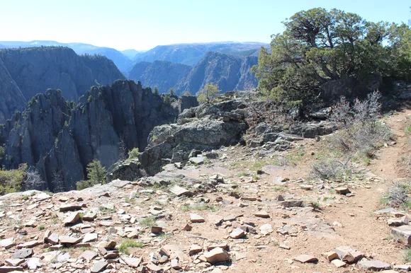
The Rim Rock Trail connects several overlooks over three miles of gentle terrain through scrub oak and Gambel oak, perfect for families who want multiple perspectives without repeating ground. Warner Point Nature Trail extends another three miles to the South Rim's end, where the canyon widens and the views shift from claustrophobic to expansive. April brings mild days in the low seventies and wildflowers coloring the sagebrush slopes, before summer heat makes the rim feel exposed.
Arches National Park
Nineteen trails beneath red stone / More arches than anywhere on Earth
Arches packs the world's highest concentration of natural stone arches into terrain small enough that every formation sits within a short drive. The trail system reflects this density: nineteen paths totaling forty-five miles, most under three miles round trip. Sand Dune Arch takes less than a mile through soft sand to reach a shaded alcove where kids can climb the dune and touch the arch's base. Balanced Rock loops three-tenths of a mile around a boulder the size of three school buses perched on a pedestal. Park Avenue runs two miles through a canyon flanked by sandstone skyscrapers, with a shuttle stop at the far end so you don't backtrack.
Delicate Arch stands alone on a slickrock bowl, framing the La Sal Mountains like a postcard that somehow survived being beaten to death.
The park gets packed, especially in April when temperatures climb into the comfortable seventies and spring break families flood in. Delicate Arch Trail requires three miles and 500 feet of elevation gain, which pushes beyond easy territory but remains achievable for motivated elementary schoolers. Devils Garden extends seven miles to Landscape Arch, the world's longest natural span, but you can turn around at two miles and still claim victory. Arrive before eight or after four to avoid parking lot roulette.
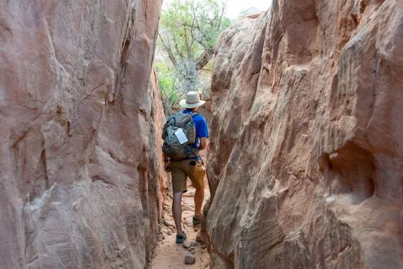
Capitol Reef National Park
Twenty-seven trails through the Waterpocket Fold / Pioneer orchards still grow
Capitol Reef stretches along a hundred-mile wrinkle in the Earth's crust where sandstone cliffs fold upward like a breaking wave frozen mid-crash. The trail system explores slot canyons, natural bridges, and the Fruita Historic District where Mormon settlers planted orchards in the 1880s that still produce fruit you can pick. Grand Wash Trail runs four flat miles through a canyon so narrow the walls block midday sun, with side slots worth exploring if you don't mind scrambling. Hickman Bridge takes two miles to reach a natural span broad enough to park a house under.
You'll walk beneath apricot trees planted by settlers who couldn't have imagined their orchard would outlast their town by a century.
The Fruita District concentrates most family-friendly trails within a few miles of the visitor center: the orchards, the petroglyphs along the cliff base, and the Cohab Canyon access trail that climbs to hidden valleys. Cassidy Arch pushes into strenuous territory with 500 feet of elevation gain, but the trail stays well-defined and the arch delivers views that justify the effort. April brings perfect temps and the orchards in bloom, before the summer crowds that pack Arches and Bryce discover Capitol Reef exists.
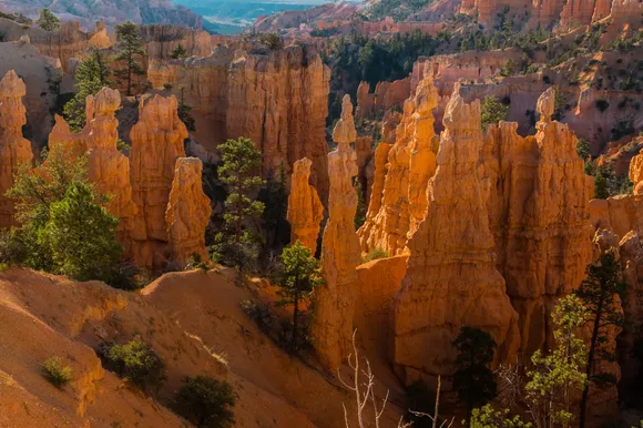
Bryce Canyon National Park
Twenty trails through hoodoo forests / Elevation hits 8,000 feet
Bryce Canyon isn't actually a canyon. It's a series of amphitheaters carved into the Paunsaugunt Plateau, where limestone eroded into thousands of hoodoos so densely packed they look like a stone city built by giants. The Rim Trail runs five and a half miles along the edge, connecting viewpoints where you can peer down into the formations without descending. Queen's Garden Trail drops into the hoodoos for less than two miles, making it the gentlest route into the amphitheater. Combine it with the Navajo Loop for a three-mile circuit that threads through Wall Street, where hoodoos lean so close you can touch both sides.
Walking between hoodoos feels like exploring slot canyons stood on end, all orange pinnacles and deep shade at 8,000 feet.
The park gets packed during peak season, but the trail system absorbs crowds better than Arches because hikers spread across multiple amphitheaters and altitude keeps many visitors at the overlooks. April brings cool mornings in the forties and afternoons in the sixties, with occasional snow showers that dust the hoodoos white against orange sandstone. Tower Bridge Trail offers a quieter two-mile alternative to the Navajo Loop, reaching formations that look like London Bridge melted into the Utah plateau.
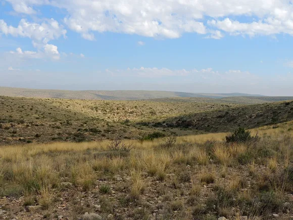
Canyonlands National Park
Thirty-five trails across four districts / Larger than Mesa Verde and Arches combined
Canyonlands sprawls across terrain carved by the Colorado and Green Rivers into districts that require separate visits. Island in the Sky concentrates the accessible trails: Grand View Point takes a fifth of a mile to reach the park's signature overlook, where canyons extend to the horizon in every direction. Upheaval Dome loops two miles around a geological mystery that looks like a meteor crater but might be a salt dome collapse. The Needles District pushes into longer territory, but Chesler Park and the Joint Trail deliver six miles of slickrock walking between sandstone pinnacles that dwarf the hikers below.
Stand at Grand View and you'll see more geology than most people encounter in a lifetime: anticlines, grabens, buttes, and mesas stacked like a textbook came to life.
The park's sheer size keeps it from feeling shoulder-to-shoulder even during busy periods. Island in the Sky sees most traffic, but trails remain manageable because the district spreads visitors across a dozen overlooks and paths. April delivers perfect hiking weather before May's peak crowds arrive, and wildflowers color the cryptobiotic soil between slickrock expanses. The Maze District stays genuinely remote, requiring high-clearance vehicles and overnight permits, but Island in the Sky keeps the experience accessible while maintaining Canyonlands' sense of scale.