8 quiet parks near major cities
Eight national parks near major cities where you'll actually have room to breathe, from volcanic spires to coral reefs
National parks near major cities tend to be jammed with shoulder-to-shoulder crowds, or they're far enough out that they require days of planning. But a handful of parks exist in that sweet spot: close enough for a long weekend, empty enough that you'll actually have room to breathe. These eight parks share that rare combination of proximity and solitude, where you can leave a major metro area in the morning and have a trail to yourself by afternoon.
May sits right in the window when most of these parks come alive. Weather settles into its stride, wildflowers carpet the hillsides, and the summer crush hasn't arrived yet. You're getting the parks at their best before everyone else figures it out.
Pinnacles National Park
90 miles from San Jose / Volcanic spires and talus caves you can crawl through
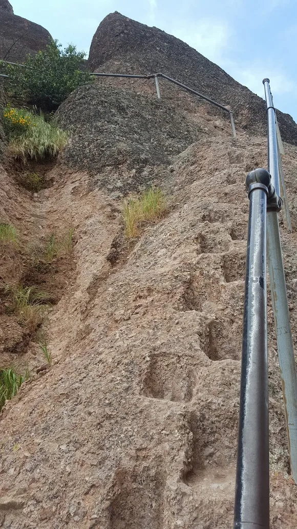
The rock spires at Pinnacles jut from the chaparral like broken teeth, remnants of an ancient volcano that tore itself apart along the San Andreas Fault. You'll climb through narrow passages where handholds have been carved into stone, scramble up the High Peaks Trail past sheer drops, and duck into Bear Gulch Caves where darkness swallows you completely until your eyes adjust. Despite drawing less than half the visitors of Yosemite, Pinnacles can still feel crowded on peak weekends, so aim for early mornings or weekdays.
The caves aren't ornamental formations behind glass but crawl-on-your-hands passages where you navigate by headlamp through boulder jams and narrow slots.
California condors circle the peaks here, part of the reintroduction program that's brought these massive birds back from near extinction. The park protects one of the few remaining strongholds for the species, and you'll see them riding thermals above the High Peaks or roosting on the spires at dawn. May brings ideal temperatures before the summer heat settles in, when the trails are accessible but not yet baking under triple-digit afternoons.
Channel Islands National Park
12 miles off the Los Angeles coast / Five islands where endemic species outnumber visitors
Channel Islands sits within sight of one of America's largest metro areas, yet most Angelenos have never heard of it. The boat ride from Ventura takes an hour, just long enough to leave the mainland's hum behind and arrive at islands where island foxes the size of housecats trot along trails and sea lions bark from kelp-strewn coves. The park sees fewer visitors than many state parks, which means you'll have entire coastlines to yourself even in peak season.
The islands support more than 140 species found nowhere else on Earth, a concentration of endemism that rivals the Galápagos.
May delivers the park's best conditions: calm seas for kayaking around sea caves, wildflowers carpeting the hillsides on Santa Cruz Island, and whale migration corridors active with gray whales heading north. The marine layer burns off by midday, revealing turquoise water that looks transplanted from the Caribbean. Anacapa Island offers the shortest boat ride and easiest introduction, while Santa Cruz provides serious backpacking terrain and the cathedral-like Painted Cave accessible only by kayak.
Congaree National Park
20 miles from Columbia / Ancient hardwoods rising from black water
The Southeast's largest remaining old-growth bottomland forest grows here in the Congaree River floodplain, where champion trees tower overhead and the canopy blocks out the sky. The Boardwalk Loop Trail puts you above the swampy ground on an elevated walkway, winding through tupelo and bald cypress that predate European settlement. Most people skip South Carolina's only national park, which means you'll walk these trails in near-solitude even though you're barely outside the capital city's suburbs.
The forest floor disappears under black water during spring floods, transforming hiking trails into kayak routes through a drowned woodland.

May sits right at the tail end of the flooding season, when water levels drop enough to reopen trails but the swamp still pulses with life. Prothonotary warblers flash gold through the understory, barred owls call from cypress knees, and the evening mosquito chorus reaches operatic levels. Bring bug spray in industrial quantities. The park offers excellent kayaking when water levels cooperate, paddling routes that take you deep into the swamp where the only sounds are your paddle and whatever's moving through the underbrush.
Biscayne National Park
15 miles from downtown Miami / Living coral reef you can snorkel without a boat
Miami's skyline floats on the western horizon while you're snorkeling over the continental United States' only living coral reef system, watching parrotfish crunch through coral heads and barracuda hang motionless in the current. The park protects a massive swath of Biscayne Bay and the northernmost Florida Keys, but most of it sits underwater. You'll need a boat to reach the reef and the offshore keys, though the park runs affordable glass-bottom boat tours if you don't have access to your own vessel.
You can watch cruise ships depart Port Miami in the morning and be snorkeling a coral reef by afternoon, a proximity that feels almost absurd.
Elliott Key and Boca Chita Key offer primitive camping on islands surrounded by turquoise water, accessible only by private boat or park concessionaire. The Mangrove Shoreline Trail at Convoy Point provides the only substantial land-based hiking, but it's worth walking for the wading birds and occasional manatee sightings. May delivers ideal conditions before summer heat and afternoon thunderstorms take over, with water warm enough for extended snorkeling and visibility that stretches past the reef to open ocean.
Guadalupe Mountains National Park
110 miles from El Paso / Texas's highest peaks rising from ancient reef
The Guadalupe Mountains erupt from the Chihuahuan Desert like a fortification, the exposed remains of a reef that formed when this part of Texas sat underwater. Guadalupe Peak tops out as the state's highest point, a brutal climb that gains more vertical than anything east of New Mexico. The park sees fewer visitors than some city parks, which means you'll have the alpine forests and limestone canyons almost entirely to yourself even on holiday weekends.
McKittrick Canyon explodes with bigtooth maples in fall, but May brings a different spectacle: wildflowers carpeting the canyon floor and streams running clear and cold from snowmelt.
The park sprawls across desert basins and mountain ridges with almost no development, just trail junctions and backcountry campsites marked by cairns. Devil's Hall Trail takes you through a narrow slot canyon to a natural rock staircase, while the Permian Reef Trail traces the ancient reef line across the mountain's base. May delivers perfect hiking weather before summer heat makes the exposed trails dangerous, with temperatures mild enough for the Guadalupe Peak summit push without the winter winds that regularly close the upper mountain.
Great Basin National Park
Hours from any traffic jam / Bristlecone pines older than the pyramids
Great Basin occupies Nevada's emptiest corner, where Wheeler Peak rises above marble caves and alpine lakes that few people bother to visit. The park sees fewer visitors than many roadside attractions, a level of solitude that's increasingly rare in the national park system. Bristlecone pines cling to the ridgelines above tree line, some pushing past their fifth millennium while you hike trails without seeing another person for hours.
Lehman Caves wind through marble chambers decorated with shield formations found almost nowhere else on Earth, a geology lesson taught in complete darkness.
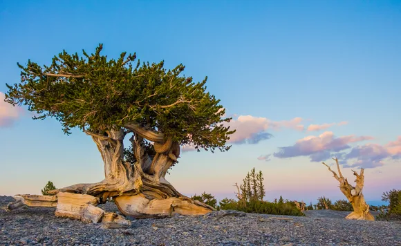
The Wheeler Peak Scenic Drive climbs from sagebrush desert to alpine tundra in less than an hour, passing through five life zones and temperature drops of 30 degrees. May sits right at the edge of accessibility, when snowfields still block the highest trails but the lower elevations open up for hiking. The Bristlecone Pine Trail leads to ancient groves above tree line, where twisted trunks and bleached deadwood testify to millennia of survival in one of Earth's harshest environments. Night skies here rank among the darkest in the Lower 48, with the Milky Way visible in detail that urban dwellers forget exists.
North Cascades National Park
Two hours from Seattle / More glaciers than any park outside Alaska
North Cascades protects the most heavily glaciated terrain in the Lower 48, a wilderness of jagged peaks and ice fields that sees fewer annual visitors than Yellowstone gets in a busy weekend. The park sits close enough to Seattle for a day trip, yet most Pacific Northwesterners have never set foot in it. More than 300 glaciers carve through the mountains here, calving into turquoise lakes and feeding waterfalls that drop thousands of feet down granite walls.
The North Cascades Highway cuts through the park like a scenic byway through the Alps, with pullouts revealing vistas that would be icons in any other park system.
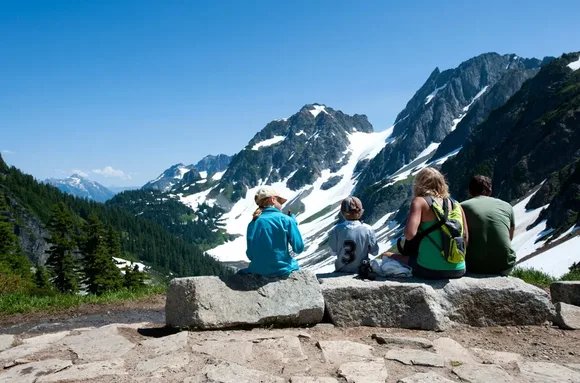
Cascade Pass Trail delivers the park's most accessible alpine scenery, climbing through old-growth forest to a high saddle where peaks stretch to the horizons in every direction. Diablo Lake glows an unnatural turquoise from glacial flour suspended in the water, a color so vivid it looks Photoshopped even when you're standing on the shore. May brings variable conditions, with trails at lower elevations clear while snow still blocks the high country. The shoulder season means even fewer visitors than usual, which translates to trails where you might be the only hiker for miles.
Lassen Volcanic National Park
Two and a half hours from Sacramento / Boiling mudpots reshaping the ground in real time
Lassen Peak erupted repeatedly between 1914 and 1917, blasting debris across the landscape and leaving behind a volcanic laboratory that's still active. Bumpass Hell bubbles and hisses with geothermal features that smell like rotten eggs and look like the planet's crust is too thin here, barely containing the heat below. Despite sitting within a few hours of major California population centers, Lassen sees a fraction of the crowds that jam Yosemite and Sequoia, leaving room to explore without elbow-to-elbow trail traffic.
The Devastated Area shows what happens when a volcano explodes: a boulder field where chunks of Lassen Peak landed miles from the summit, some the size of small houses.
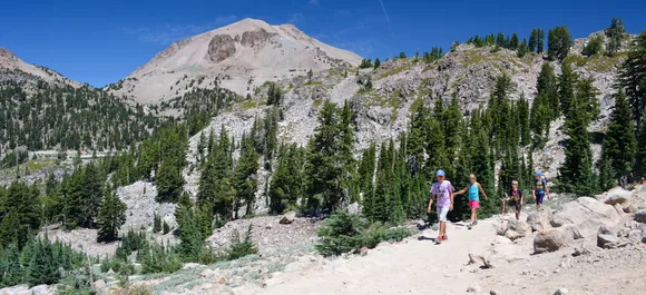
May sits right at the beginning of the season, when Lassen Park Road starts plowing through lingering snowpack and lower elevation trails emerge from winter. Manzanita Lake Loop offers easy walking with Lassen Peak reflecting in still water, while the Lassen Peak Trail climbs to the summit through snowfields and scree. Kings Creek Falls drops through a narrow slot canyon accessible via a short hike that most visitors skip, leaving the falls and the surrounding meadows nearly empty even on summer weekends. The park's campgrounds fill more slowly than comparable parks, making last-minute camping actually feasible.