8 uncrowded parks with incredible caves
Eight parks where significant cave systems meet smaller crowds, from Kentucky's endless passages to volcanic tubes beneath alpine peaks
Most parks hide their caves behind popular trails and crowded overlooks. These eight protect cave systems significant enough to define the park itself, yet remain obscure enough that you can still get underground tickets on short notice. April brings mild weather to most of them, making it easier to combine subterranean exploration with surface hiking before summer heat or monsoon rains arrive.
The caves range from marble formations beneath alpine peaks to limestone labyrinths stretching longer than the distance between Boston and Philadelphia. Some you explore on guided tours with rangers, others by flashlight on your own. What they share is breathing room above and below ground.
Carlsbad Caverns National Park
Southwest New Mexico desert / Big Room larger than six football fields / True hidden gem
Carlsbad's caves formed through sulfuric acid dissolution rather than the typical water erosion, creating formations you won't see anywhere else in the National Park System. The Big Room sits 750 feet underground and stretches so far you'll walk more than a mile just to loop it. Unlike most cave tours, you're not stuck in a single-file line listening to a ranger. You descend on your own, move at your own pace, and spend as long as you want staring up at stalactites the size of redwood trunks.
The Natural Entrance Trail drops you 750 feet through switchbacks carved into the cave mouth itself, a descent that feels more like entering a cathedral than a hole in the ground.
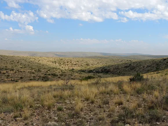
Above ground, the Chihuahuan Desert stretches emptier than most people expect. The Guadalupe Ridge Trail and Rattlesnake Canyon routes take you through high desert terrain where lechuguilla and sotol thrive in soil that looks like it can't support anything. From late May through October, around 400,000 Mexican free-tailed bats spiral out of the cave at dusk in a tornado of wings visible from the amphitheater. Rangers lead bat flight programs most evenings during peak season, but you can watch from the amphitheater benches on your own any night the bats are active.
Great Basin National Park
Eastern Nevada / Five hours from Las Vegas / Ancient bristlecone pines above marble caves
Lehman Caves sits at the base of Wheeler Peak, Nevada's second-highest summit. The cave tour winds through marble chambers filled with shields, rare formations that look like giant clams embedded in the ceiling. Tours run year-round and rarely sell out outside of July and August. Above ground, Wheeler Peak towers over terrain that shifts from sagebrush desert to alpine tundra in less than an hour's drive up the scenic road.
You can explore marble caves in the morning and stand among 4,000-year-old bristlecone pines by afternoon without seeing more than a dozen other people all day.
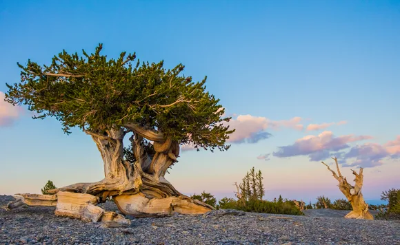
The Bristlecone Pine Trail takes you to some of the oldest living trees on earth, gnarled survivors clinging to rocky slopes at 10,000 feet. The trail gains only 600 feet over its three-mile round trip, making it accessible for most visitors despite the elevation. If you're up for something more demanding, the Wheeler Peak Trail climbs to the summit through alpine lakes and permanent snowfields. Great Basin gets fewer visitors than most national monuments, which means you'll have trails and viewpoints largely to yourself even during the park's busiest month of September.
Mammoth Cave National Park
Central Kentucky / Longer than any other cave on earth / More than 400 miles mapped and still growing
Mammoth Cave stretches so far that if you walked every mapped passage you'd cover more distance than a straight line from Louisville to Miami. No single tour covers more than a fraction of it. The Historic Entrance Tour follows routes used by miners in the 1800s, while the Frozen Niagara Tour showcases flowstone formations that look like waterfalls frozen mid-cascade. Above ground, 85 miles of surface trails wind through karst landscape and hardwood forest, though most visitors stick to the cave tours and miss the Green River Bluffs Trail entirely.
Rangers turn off their flashlights during cave tours to demonstrate absolute darkness, a blackness so complete your eyes never adjust no matter how long you wait.
April brings ideal conditions for combining underground and surface exploration before summer humidity makes the forest trails sticky and oppressive. The cave maintains a constant temperature around 54 degrees year-round, which feels refreshing in July but requires a jacket in winter. Mammoth attracts more visitors than most people realize, but the park spreads them across dozens of tour times and surface trails. Book cave tours in advance through the park's reservation system, especially if you're visiting during spring break or fall foliage season.
Pinnacles National Park
Central California / Volcanic spires and talus caves / Two hours from San Jose
Pinnacles formed from a volcano that erupted 23 million years ago 195 miles south of its current location. Tectonic forces along the San Andreas Fault dragged the formations north over millennia, creating the jumbled landscape of spires and boulder fields you see today. The talus caves formed when house-sized rocks tumbled into narrow canyons and wedged against each other, creating passages you navigate by flashlight and occasional ladder. Bear Gulch Cave opens seasonally to protect nesting bats, typically from mid-July through mid-May, while Balconies Cave stays open year-round.
You'll crawl through sections of Bear Gulch where daylight disappears completely and the ceiling drops low enough to scrape your backpack.
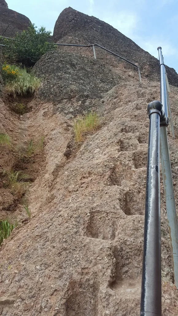
Above the caves, the High Peaks Trail traverses knife-edge ridges with handrails bolted into the rock and stone steps carved into near-vertical pitches. California condors soar overhead, massive birds with wingspans approaching ten feet. The park sits far enough from major cities that most Bay Area residents have never heard of it, yet close enough for a comfortable day trip. April brings wildflowers to the chaparral hillsides before heat makes the exposed trails brutal. The park has east and west entrances with no through road connecting them, so plan your route based on which trailhead you're targeting.
Wind Cave National Park
South Dakota's Black Hills / Boxwork formations found almost nowhere else / Bison and prairie dogs above ground
Wind Cave earned its name from air that rushes in and out of the entrance depending on barometric pressure, sometimes strong enough to knock off your hat. Below ground, the cave contains 95 percent of the world's known boxwork, calcite formations that create honeycomb patterns on the ceiling like something out of a geometry textbook. The Natural Entrance Tour takes you through passages decorated with these rare formations, while more adventurous options like the Wild Cave Tour require crawling through gaps barely wider than your shoulders.
The cave breathes with changes in atmospheric pressure, exhaling air that early settlers could hear whistling through prairie grass from hundreds of feet away.
Above the cave, mixed-grass prairie rolls across hills where one of the country's largest bison herds grazes alongside pronghorn and elk. The Elk Mountain Trail climbs through ponderosa forest to ridge views across the prairie, while the shorter Wind Cave Canyon Trail stays in the lowlands where you're more likely to spot wildlife. Most visitors spend an hour underground then drive to Mount Rushmore or Badlands without exploring the surface trails. April can bring unpredictable weather to the Black Hills, but temperatures stay mild enough for both cave tours and prairie hiking.
Lassen Volcanic National Park
Northern California / Lava tube caves near active geothermal features / Almost nobody here
Lassen Peak erupted repeatedly between 1914 and 1917, and the landscape still shows the violence. Bumpass Hell churns with boiling mudpots and sulfurous vents, while the Devastated Area preserves terrain buried under volcanic debris during the eruption sequence. The park's lava tube caves formed when molten rock drained from beneath hardened surfaces, leaving hollow tunnels you can explore with a flashlight and hard hat. Subway Cave, technically just outside park boundaries, offers the easiest access for families who want to experience what walking through a lava tube feels like.
The ground still steams at Bumpass Hell, where boardwalks protect you from crust thin enough to break through into boiling mud below.

Lassen sits far enough north that most California tourists bypass it for Yosemite or Sequoia, which means you'll have trails nearly to yourself even during the park's brief summer season. Snow closes the main park road from November through June most years, concentrating visitation into a narrow window. April typically keeps the road closed, but by late June you can drive the full route and hike to alpine lakes that stay ice-choked into July. The Lassen Peak Trail climbs to the summit through volcanic rubble, gaining more than 2,000 feet over five miles. Families stick to easier routes like the Manzanita Lake Loop, where kids can spot deer and waterfowl against a backdrop of the volcanic peak.
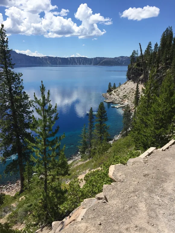
Crater Lake National Park
Southern Oregon / Volcanic caldera holding America's deepest lake / Pumice caves near Rim Road
Mount Mazama collapsed into its own magma chamber 7,700 years ago, creating the caldera that eventually filled with snowmelt to become Crater Lake. The lake reaches depths approaching 2,000 feet, and its purity makes it one of the clearest bodies of water on earth. The 33-mile Rim Road circles the crater with pullouts every few miles for views across water so blue it looks photoshopped. Near the rim, pumice caves formed in volcanic deposits, short tunnels you can explore without a guide or permit.
The water is so pure that scientists use Crater Lake as a baseline for studying pollution in other bodies of water.
The Cleetwood Cove Trail drops more than 700 feet to the water's edge, the only route providing lake access. Boat tours to Wizard Island depart from the cove dock, but you'll earn them with a steep climb back to the rim afterward. Most of the park stays buried under snow from October through June, turning Crater Lake into a winter wonderland accessible mainly by cross-country skis or snowshoes. July and August bring the most reliable conditions for driving the full Rim Road and hiking to destinations like Watchman Peak, where you'll get sunset views across the caldera that justify every switchback. The park draws fewer visitors than its beauty warrants, partly because snow limits access for most of the year and partly because it sits hours from major cities.
Canyonlands National Park
Southeast Utah / Horseshoe Canyon pictographs in alcoves / Four districts bigger than Los Angeles combined
Horseshoe Canyon, a detached unit of Canyonlands, protects some of the most significant rock art in North America. The Great Gallery features life-sized pictographs painted on canyon walls thousands of years ago, haunting figures that stand eight feet tall in alcoves sheltered from weather. You'll hike seven miles round trip through sandy washes to reach them, but the canyon sees a fraction of the crowds jamming Island in the Sky's overlooks. The Needles District contains slot canyons and natural arches you access by scrambling through narrow gaps in the rock.
The pictographs in Horseshoe Canyon predate Egyptian pyramids, painted by cultures we know mainly through the images they left on stone.
Island in the Sky provides the easiest access and biggest views, perched 1,000 feet above the surrounding terrain with overlooks you can drive to without hiking. The Maze remains so remote and rugged that most visitors never attempt it, requiring high-clearance four-wheel drive just to reach trailheads. April brings ideal temperatures for desert hiking before summer heat makes exposed trails dangerous without dawn starts and excessive water carries. The Colorado and Green Rivers converge deep in the canyons below Island in the Sky, visible from overlooks but requiring serious effort to reach on foot. Canyonlands spreads visitors across enough terrain that even popular areas like Grand View Point rarely feel shoulder-to-shoulder crowded.