The 8 Most Crowded National Parks (and When to Go Instead)
The eight most crowded national parks, ranked by density, and the exact month to visit each one without the bottleneck
The most useful crowding metric for a national park isn't the annual visitor count. It's how much park each person gets. A place that draws millions across a thousand square miles can still feel genuinely empty in the right corner. A place that draws the same millions through a single road, or across a footprint smaller than many city neighborhoods, cannot. These eight parks earned their spots by concentrating pressure in ways raw totals don't reveal: too small, too funneled, or too near a major city to absorb what they draw.
Every park here has a better window. Here is where the crunch is, and when each one resets.
Hot Springs National Park
A national park inside a working city / Bathhouse Row, 143-degree springs, and June sidewalks that belong to everyone
Hot Springs operates on different terms than any other national park. It sits inside the city of Hot Springs, Arkansas, along a Victorian boulevard where mineral-rich water flows at 143 degrees into marble bathhouses that once served health seekers, bootleggers, and Al Capone with roughly equal hospitality. The park's footprint is so compact that June's full visitor pressure has nowhere to disperse. Bathhouse Row functions more like a downtown main street than a wilderness trail, and in summer it feels exactly that way.
Hot Springs was built for slow, therapeutic loitering: summer's shoulder-to-shoulder sidewalks won't allow it.
October is when the park makes sense. Temperatures settle into the 60s, the mountain trails above the bathhouse district quiet down, and you can tour the Fordyce Bathhouse museum without waiting for groups to clear the gallery. The Gulpha Gorge Trail climbs from the campground into forested ridges above the city and feels genuinely remote for a park this close to everything. The thermal water still flows at 143 degrees, unchanged by the calendar.
Indiana Dunes National Park
Fifteen miles of Lake Michigan shoreline, 30 miles from Chicago / July belongs to the whole Midwest
Indiana Dunes earns its spot through proximity. It is the closest national park to the largest metropolitan area in the Midwest, which means summer weekends draw anyone from Chicago who didn't want to fight traffic to Michigan. The beach at West Beach fills before noon. The trails above it, including Dune Succession and Mount Jackson, deliver something genuinely surprising: four distinct ecosystems in under three miles, from open shore through bog, forest, and prairie. In July, you make that walk in a line.
Indiana Dunes is proof that proximity to a major city is the most powerful force in national park management.
September changes the equation. The lake stays warm enough to swim into early fall, the inland marsh trails are exceptional for birding, and the Miller Woods Trail through oak savannas and open dunes feels nothing like the main beach corridor. Kids can earn their Junior Ranger badges along the shoreline, and the dune ecology that's harder to appreciate in peak crowds becomes the main event.
Zion National Park
More annual visitors than Los Angeles has residents / All of them through one canyon road
Zion's crowding problem is architectural. The same narrow canyon walls that create its scale and grandeur also concentrate every visitor into a single corridor. The park runs mandatory shuttle buses along the main road, which helps, but every shuttle deposits passengers at the same five trailheads. Angels Landing requires a permit lottery and still draws more applicants than most concerts. The Narrows, a wade up the Virgin River through a slot canyon that requires no permit, becomes a slow procession upstream in June.
The canyon that makes Zion extraordinary also makes it unavoidable.
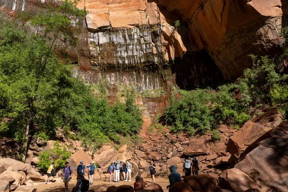
April is the park's sweet spot: temperatures run in the 60s and 70s, wildflowers bloom on the canyon floor, and the Narrows runs clear before spring runoff peaks. The Canyon Overlook Trail delivers canyon views that rival Angels Landing at a fraction of the effort and foot traffic. For families, the Pa'rus Trail along the river is paved, flat, and one of the few in the park that allows dogs.
Arches National Park
More than 2,000 natural stone arches / One entrance, one road, one inevitable queue
Arches has the geographic misfortune of being both remarkable and inescapable. There is one way in and one way out. The Delicate Arch trail, the walk to the image on Utah's license plate, is the trail everyone does. On peak summer mornings the entrance road backs up onto the highway, and triple-digit temperatures push hikers to start before dawn, concentrating everyone into the same narrow early window. The park is compact enough that this compression is felt everywhere simultaneously.
Two thousand arches and one bottleneck: Arches earns its crowds and then suffers for it.
April and October return the park to a reasonable scale. Temperatures are comfortable, the light is better for photography at both ends of the day, and Fiery Furnace walking tours are easier to secure. The Devils Garden Trail, at the far end of the park road, is long enough that the back half empties out: Landscape Arch requires a two-mile walk each way, which filters foot traffic naturally. Kids love Balanced Rock and Sand Dune Arch, where the enclosed dune field stays cool even on warm afternoons.
Bryce Canyon National Park
The world's densest hoodoo forest at 8,000 feet / Compact enough that the crowds concentrate fast
Bryce Canyon's plateau layout puts every overlook above the same amphitheater of orange spires. Sunrise Point, Sunset Point, and Inspiration Point all sit within easy walking distance of main parking areas, so they fill quickly and stay full through midday. The Navajo Loop drops you into the hoodoo forest between pillars narrow enough to touch on both sides, but peak season turns that descent into an orderly procession. September, not July, is actually the park's peak month by visitor count, which surprises most first-timers.
The hoodoos aren't going anywhere, but the solitude has a much narrower window than most visitors expect.
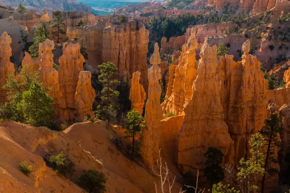
May is the better visit. Temperatures at 8,000 feet are mild after snowmelt clears the lower trails, and the rim wildflowers are at their best. The Queen's Garden Trail drops into the canyon gently enough for older kids and connects to the Navajo Loop for a longer circuit if you want it. The free park shuttle runs between all major viewpoints from April onward, so you can park once at the visitor center and cover the whole rim without fighting for overlook spots.
Haleakalā National Park
A volcanic summit above the clouds at 10,000 feet / Sunrise requires a reservation and three weeks of planning
Haleakalā's crowding is uniquely infrastructural. The park requires a timed entry reservation just to drive to the summit for sunrise, and those slots sell out weeks in advance. The underlying issue isn't total visitor volume so much as timing: the experience everyone comes for unfolds in a 90-minute window at dawn, from a single vantage point, and demand far exceeds the available slots. The crater itself is worth understanding on its own terms, volcanic and genuinely disorienting, with red and black cinder and silversword plants growing nowhere else on Earth.
There is only one sunrise over the crater, and everyone on Maui knows it.
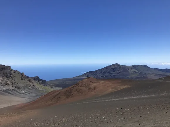
The Kīpahulu district on the park's eastern coast is the part most visitors miss entirely. Accessed via the Road to Hana, it sits in a completely different climate zone: tropical, lush, and far less visited than the summit. The Pipiwai Trail climbs through a bamboo forest that filters sound and light in equal measure, ending at Waimoku Falls, a narrow column of water dropping through fern-covered tropical cliffs. On most mornings you'll have the boardwalk nearly to yourself, which says something about how underused this half of the park remains.
Saguaro National Park
The only national park that wraps entirely around a city / March crowds rival the cacti for density
Saguaro's geography is its destiny. Two districts surrounding Tucson on opposite sides means the park is never more than a short drive from everyone who lives there, and March draws all of them: wildflowers blooming, temperatures in the 70s, and the collective realization that the park is right there. The west district's Bajada Loop Drive puts you among the densest saguaro stands anywhere. Some of these cacti have been growing since before the American Revolution, and the sheer density of them reframes every assumption about what a desert looks like. On peak March weekends, Hugh Norris trailhead parking fills early.
The saguaros have been standing for 200 years; the crowds are a much more recent development.
November reclaims the park. Temperatures drop to comfortable hiking range and summer visitors are long gone. The east district's Mica View Trail offers a more solitary approach to the saguaro forest, with longer access roads that filter out casual visitors naturally. The Desert Discovery Trail in the west district is paved and accessible, a good first walk for kids encountering the Sonoran Desert, and in November it moves at whatever pace you set. The two districts are 30 miles apart by road and feel different enough to justify visiting both in a single day.
Acadia National Park
A granite island off the Maine coast / Draws nearly three times Maine's entire population each year
Acadia is the northeast's benchmark national park, which means it carries the full weight of that status in August. Cadillac Mountain offers the first sunrise in the continental United States for much of the year. The carriage roads through the interior forest are among the most carefully maintained multi-use trails in the country. Jordan Pond anchors one of the most reproduced landscape views in New England. Every one of these draws concentrates visitors on a granite island with finite roads, finite parking, and a Park Loop Road that moves at a social pace on peak summer weekends.
Acadia is the rare park where the infrastructure is excellent and still not quite enough.
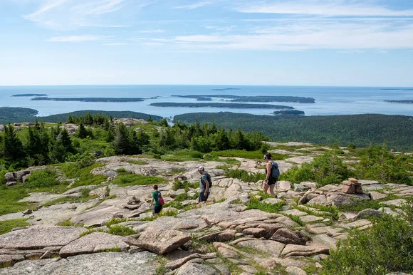
May changes the math entirely. The carriage roads are clear, the crowds haven't arrived, and trails on the quieter eastern and northern sections of the island feel genuinely empty. The Beehive Trail, an iron-runged climb up granite cliffs above Sand Beach, is the most exhilarating hike for its length in the park, and in May you'll have room on the rungs. The Jordan Pond House popovers are a legitimate local tradition worth experiencing before the August wait list begins.