The 8 Oldest National Parks in America
The eight oldest national parks, ranked by establishment date, from Yellowstone's 1872 debut to Petrified Forest's stone trees
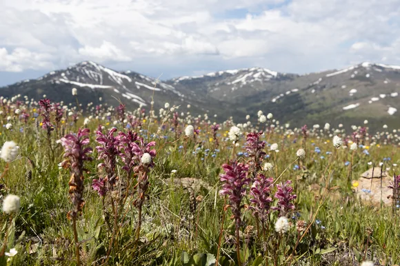
Congress invented the national park in 1872, but it took another thirty years before anyone called it a "system." These eight parks are the original blueprints, each one an experiment in whether America could protect landscapes without destroying them. They weren't chosen for their size or their visitor numbers. They were chosen because someone saw them, imagined them gone, and refused to let that happen.
This is the chronological ranking of America's oldest national parks, ordered by establishment date. If you want to understand what the park idea looked like before Instagram, before paved roads, before anyone thought conservation could scale, start here.
Yellowstone National Park
Larger than Delaware and Rhode Island combined / Draws more visitors than the population of Los Angeles
The world's first national park sits on a supervolcano where half of Earth's geysers erupt on schedule and bison herds cross roads without concern for your itinerary. Established in 1872, Yellowstone became the template every other park would follow, though Congress didn't actually fund it until 1878. You'll find more geothermal features here than anywhere else on the planet, from Old Faithful's clockwork eruptions to Grand Prismatic Spring's psychedelic runoff channels that look airbrushed even in person.
Yellowstone's sheer size absorbs the crowds in ways newer parks never could — you can drive for an hour and see nothing but forest and sky.
The park's alpine climate keeps July afternoons in the low seventies, which explains why summer is peak season despite the traffic. Lamar Valley at dawn delivers wolves, grizzlies, and herds of bison that number in the hundreds. The Grand Canyon of the Yellowstone drops deeper than Niagara Falls, and most visitors never make it past the south rim overlook. If you want solitude, push past the first viewpoint on any trail. Most people don't.
Sequoia & Kings Canyon National Parks
Established the same week as Yosemite / Home to the largest tree on Earth by volume
Congress signed Sequoia into existence on September 25, 1890, making it the second national park by six days. General Sherman Tree anchors a grove where trunks exceed thirty feet wide and branches thicker than most trees reach toward a canopy you can't see from the ground. The park absorbed Kings Canyon in 1940, creating a single unit that stretches from foothills to alpine granite. Most visitors photograph General Sherman, walk the Big Trees Trail, and leave. They're missing the point.
The giant sequoias here aren't just big — they're old enough to have been saplings when Rome fell.
Kings Canyon drops eight thousand feet from rim to river, making it one of the deepest canyons in North America. The High Sierra Trail connects Sequoia to Mount Whitney, and backpackers disappear for days into terrain that looks more like the Alps than California. Moro Rock's granite staircase climbs four hundred vertical feet in a quarter mile, delivering views that stretch to the Coast Range when wildfire smoke allows. The park stays uncrowded even in July because Yosemite siphons off most of the tourist traffic.
Yosemite National Park
Granite cliffs rise three thousand feet from the valley floor / Draws more visitors than all but six other parks
Yosemite became a national park one week after Sequoia, though the valley itself had been protected since 1864 under a state grant Lincoln signed mid-Civil War. El Capitan and Half Dome anchor a valley carved by glaciers and polished smooth by millennia of ice. Yosemite Falls drops twenty-four hundred feet in three tiers, making it one of the tallest waterfalls in North America when snowmelt fills the creeks in May. By August it's a trickle. By September it's dry.
The valley floor draws shoulder-to-shoulder crowds in summer, but the high country stays empty because most visitors never leave the pavement.
Half Dome's cable route requires a permit lottery and attracts thousands of applicants for hundreds of slots. The Mist Trail to Vernal Fall delivers soaking spray and granite stairs so steep you'll feel it for days. Mariposa Grove holds five hundred mature giant sequoias, including the Grizzly Giant, which was already ancient when Columbus landed. The park stays open year-round, but Tioga Pass closes with the first snow and doesn't reopen until May or June. Come in September for clear skies, thin crowds, and waterfalls that still run.
Mount Rainier National Park
An active volcano cloaked in more glaciers than any Lower 48 peak / Established 1899
Mount Rainier became the fifth national park in 1899, protecting an active volcano that spawns five major rivers from ice beginning at over fourteen thousand feet. The mountain holds more glacial ice than all other Cascade peaks combined, and those glaciers are melting faster than scientists predicted even a decade ago. Paradise receives more annual snowfall than almost anywhere in the world, burying the visitor center under drifts that don't melt until July. The Skyline Trail loops through alpine meadows that bloom with lupine and paintbrush in late summer, delivering views of the summit that look close enough to touch.
Rainier dominates the Seattle skyline on clear days, but those days come less often than the brochures suggest.
The park's proximity to Seattle makes it crowded on summer weekends despite its alpine climate keeping afternoon highs in the low sixties. Sunrise sits on the mountain's drier east side, delivering better weather and thinner crowds than Paradise. Reflection Lakes mirror the peak on calm mornings, and the Trail of the Shadows loops through old-growth forest on a path so easy toddlers can manage it. Ranger programs run daily at Paradise and explain the geology in terms that make the mountain's volcanic threat feel immediate rather than theoretical.
Crater Lake National Park
America's deepest lake fills a volcanic caldera / Severely underrated despite the scenery
Crater Lake became a national park in 1902, protecting a caldera that filled with snowmelt over seven thousand years after Mount Mazama collapsed. The lake's water is so pure that scientists use it as a baseline for clarity measurements, and the blue looks Photoshopped even when you're standing at the rim. Wizard Island rises from the lake's west side, a cinder cone you can reach by boat if you're willing to hike the Cleetwood Cove Trail, the only legal access to the water. The trail drops seven hundred feet in just over a mile, and you'll climb every foot of it on the way back up.
The Rim Drive circles the crater for thirty-three miles, and every pullout delivers a view that resets your baseline for what blue can look like.
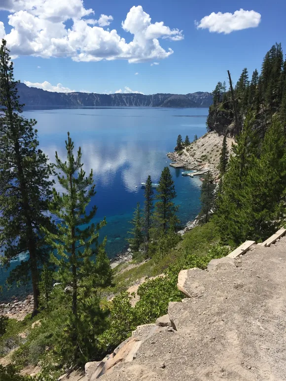
Snow closes most of the park from October through June, compressing the season into a summer window that draws manageable crowds despite the peak in July. The Watchman Trail climbs to a fire lookout that frames the lake against the southern Oregon Cascades, and the Discovery Point Trail traces the rim to the spot where prospectors first saw the water in 1853. Crater Lake draws fewer visitors than parks half its size, partly because the nearest major city sits nearly a hundred miles away. That isolation is the point.
Wind Cave National Park
One of the world's longest caves beneath mixed-grass prairie / Draws half a million visitors who mostly stay underground
Wind Cave became a national park in 1903, protecting a cave system where ninety-five percent of the world's boxwork formations twist through limestone passages that stretch for over a hundred fifty miles. The cave's natural entrance breathes in and out with barometric pressure changes, creating winds that early settlers heard from miles away. Most visitors spend an hour underground on a ranger-led tour, then drive away without realizing the prairie above holds one of the continent's last intact bison herds.
The cave gets crowded despite its reputation as a hidden gem because there's only one way in and tours book out days in advance.
Elk Mountain Trail loops through ponderosa pine and prairie grassland where bison graze close enough to the path that rangers close sections without warning. The park's semi-arid climate keeps summer highs in the mid-eighties, and the cave stays at a constant fifty-three degrees year-round. Wind Cave Canyon Trail follows a dry wash through rock walls that frame the Black Hills to the west, and the Heritage Trail connects the visitor center to the natural entrance on pavement flat enough for wheelchairs. Book your cave tour the morning tickets open online if you're visiting in summer.
Mesa Verde National Park
Seven hundred Ancestral Pueblo dwellings carved into sandstone alcoves / Established 1906
Mesa Verde became the first park created to protect cultural resources rather than scenery, and it remains the only one where archaeology matters more than geology. Cliff Palace holds a hundred fifty rooms carved into an alcove so large it creates its own microclimate, and you'll climb ladders to reach doorways built for people a foot shorter than modern Americans. The Ancestral Pueblo people lived here for seven hundred years before abandoning the cliff dwellings around 1300 CE, and archaeologists still debate why they left.
You can't visit the major cliff dwellings without a ranger because the structures are too fragile and the ladders too steep for unsupervised access.
Balcony House requires climbing a thirty-two-foot ladder and crawling through a stone tunnel on hands and knees, which keeps families with young children on the Cliff Palace tour instead. The Mesa Top Loop Road connects surface sites that show how the Pueblo people lived before moving into the alcoves, and Spruce Tree House sits close enough to the museum that you can see it from the overlook without joining a tour. The park stays uncrowded despite drawing half a million visitors because most people visit between April and October when the high desert climate keeps days in the seventies.
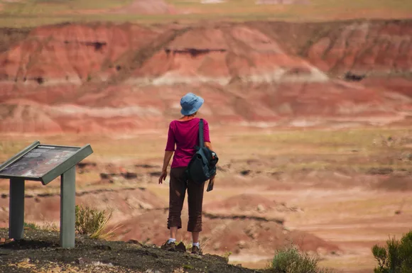
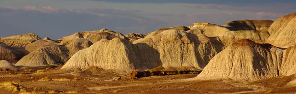
Petrified Forest National Park
Two-hundred-twenty-five-million-year-old trees turned to stone / Twenty-eight miles of road through technicolor badlands
Petrified Forest became a national monument in 1906 and graduated to park status in 1962, protecting a landscape where fossilized wood sprawls wider than cars and badlands glow purple at sunset. The petrified logs aren't wood anymore but quartz that replaced the organic material cell by cell, preserving growth rings in stone that weighs more than the original trees ever did. Blue Mesa Trail drops through bentonite hills that erode visibly with every rainstorm, and the colors shift from gray to purple to rust depending on the light.
The Painted Desert stretches north from the visitor center in waves of stratified color that look better at dawn than any other time of day.
The park has no campgrounds and no lodging, which keeps most visitors moving through in three hours or less. Newspaper Rock displays petroglyphs etched by ancestral peoples over thousands of years, and the Long Logs Trail loops through a concentration of petrified trunks so dense you'll step over them to stay on the path. The park stays open year-round because the high desert climate keeps winter lows in the forties, but summer afternoons hit the upper eighties and there's no shade anywhere on the trails.