The Southeast national parks road trip
Six Southeast parks that trade desert drama for thick forest, rushing water, and trails you can hike in summer without melting
The Southeast doesn't get the same backcountry mythology as the Rockies or the desert Southwest, but its national parks deliver something the West can't: thick forest, rushing water, and trails you can actually hike in summer without starting at dawn. September brings the transition from humid to tolerable, the first hints of color in the canopy, and enough space on the trails to remember why you came in the first place.
This road trip strings together six parks that span the region's full range: ancient mountains, the world's longest cave, a river gorge that cuts deeper than most Western canyons, bottomland forest that floods every spring, and a historic canal path that runs through Ohio suburbs. None of them require permits for day hikes. Most are uncrowded outside peak leaf season. All of them reward September visitors with weather that feels like a concession after months of oppressive heat.
Great Smoky Mountains National Park
More trail miles than most states have highways / America's most-visited park
The Smokies draw more people than any other national park in the country, but the numbers tell only half the story. Most visitors never leave their cars. They cruise through Cades Cove at five miles per hour, windows down, hoping for a bear sighting. They park at Laurel Falls, walk the paved trail, take the photo, and drive to the next overlook. If you're willing to climb, you'll find solitude on trails like Alum Cave to Mount LeConte, where the reward for a thousand feet of elevation gain is a ridgeline that stretches toward North Carolina with no guardrails and no crowds.
The Smokies earned their name from the blue haze that hangs over the ridges — a mix of moisture and organic compounds released by the forest itself.
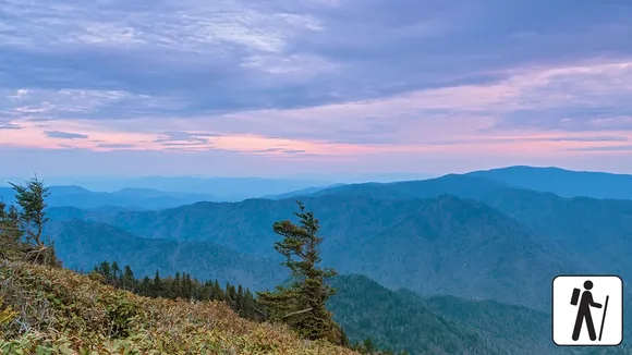
September sits in the gap between summer humidity and peak October color, which means you'll have the trails mostly to yourself. The park protects the continent's salamander capital, with more species than anywhere else on Earth, and Cades Cove's historic farmsteads look almost inhabited in the early morning light. Clingmans Dome rises higher than any peak in the Appalachians south of New Hampshire, but the observation tower at the summit fills with tour buses by mid-morning. Go at sunrise or skip it entirely.
Shenandoah National Park
Skyline Drive traces the Blue Ridge for 105 miles / Peak color comes in mid-October
Shenandoah wraps around Skyline Drive, a Depression-era road that follows the ridgeline from Front Royal to Rockfish Gap. The drive delivers overlook after overlook, each framing a slightly different angle on the Shenandoah Valley, but the real park starts when you step off the pavement. Old Rag Mountain pulls hikers up a granite scramble that requires both hands and a tolerance for exposure. Dark Hollow Falls drops you into a hollow where the trail follows a creek through a hemlock grove that stayed intact when everything around it was farmland.
The hollows were cleared and farmed until the 1930s, when the federal government bought out the families and let the forest return.
September brings mild days in the low 70s and nights cool enough for a fire. The park sits close enough to Washington, D.C., that you can drive from the Capitol to a backcountry campsite in under two hours, but most visitors stick to the overlooks and the short trails near Skyline Drive. Overall Run Falls requires a longer push, but it's the tallest waterfall in the park and sees a fraction of the traffic that Dark Hollow pulls. If you want to watch sunset from a ridge without sharing it with a tour bus, hike Hawksbill Summit in the late afternoon and stay until the valley goes dark.
Mammoth Cave National Park
The world's longest cave system / Over 400 miles mapped and still growing
Mammoth Cave doesn't fit the national park template. There are no towering peaks, no dramatic overlooks, no herds of elk grazing in meadows at sunset. The park exists because of what's beneath your feet: a limestone labyrinth that's been explored for over 200 years and still reveals new passages every year. You'll see the cave on a ranger-led tour, which means you're trading freedom for access. The Historic Entrance Tour covers the oldest sections, where guides point out 19th-century graffiti and explain how enslaved people guided the first paying tourists through the darkness.
The cave stays 54 degrees year-round, which makes it the best escape in the Southeast when August refuses to quit.
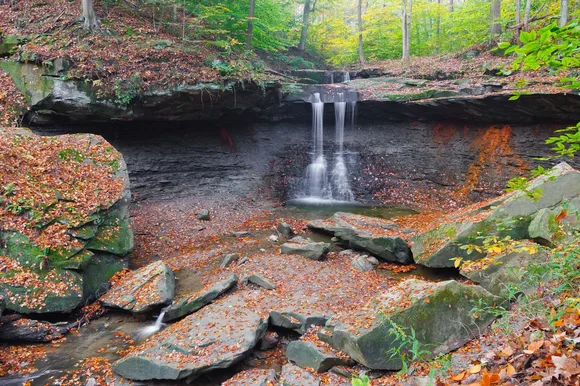
Aboveground, the park protects a plateau of rolling forest and karst topography, where sinkholes and springs mark the places where the cave system breathes. The Green River Bluffs Trail follows the riverbank through hardwood forest, and you'll pass more wildflowers in spring than most people associate with Kentucky. September brings comfortable weather for surface trails and no competition for tour tickets. The Frozen Niagara Tour shows off the cave's best formations, but it's also the most crowded. If you want to see the cave's scale without the crowds, book the longer Wild Cave Tour, which requires crawling and a tolerance for darkness.
New River Gorge National Park & Preserve
The East Coast's deepest river gorge / Cuts a thousand feet through ancient rock
New River Gorge became a national park in 2020, which makes it the newest in the system, but the gorge itself predates the Appalachians. The New River is one of the oldest on the continent, and it carved a canyon that rivals anything in the West for depth and drama. The gorge drops a thousand feet from rim to river, and the walls hold some of the best rock climbing east of the Rockies. Whitewater rafters run Class V rapids through the narrows, while hikers follow trails that cling to the rim and offer views that stretch for miles.
The New River Gorge Bridge arches 876 feet above the water, high enough that BASE jumpers gather here once a year to leap from the catwalk.
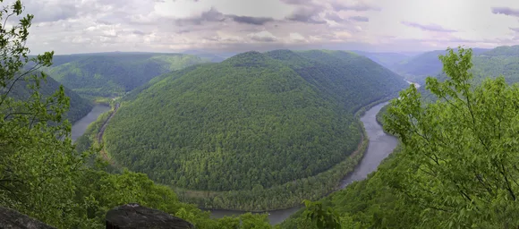
September brings warm days and cool nights, and the park sees fewer visitors than July's peak season. The Grandview Overlook Trail delivers the best view of the gorge with minimal effort, but the Prince Wharton Juniper Trail drops into the canyon and follows the rim through forest that transitions from oak to hemlock as you descend. The park's size absorbs the crowds better than you'd expect, and the trails above the gorge stay quiet even on weekends. If you want to see the river up close, book a rafting trip through the lower gorge, where the rapids ease up enough for beginners but the scenery stays dramatic.
Congaree National Park
The largest old-growth bottomland forest in the Southeast / Champion trees you'll reach via boardwalk
Congaree protects a floodplain forest that most people have never heard of, which is part of its appeal. The Congaree River floods the forest every few years, which keeps the understory clear and the trees towering. You'll walk the Boardwalk Loop Trail, an elevated path that winds through the canopy, where loblolly pines rise over 150 feet and bald cypresses stand in water that reflects the sky. The park holds more champion trees — the largest of their species — than almost any other site in the country, and you'll spot them marked with plaques along the trail.
The forest floods in winter and spring, turning the boardwalk into the only dry path through a landscape that feels more like a swamp than a forest.
September sits between the summer humidity and the fall mosquito die-off, which makes it tolerable but not comfortable. The park stays open year-round, and the ranger programs focus on the ecology of flooding and the species that depend on it. If you want to see the forest from the water, rent a canoe and paddle Cedar Creek, which winds through the park and offers views of the canopy from below. The park sees fewer visitors than any other on this list, which means you'll have the trails to yourself most of the time. It's the kind of place that rewards patience and curiosity, not bucket-list photos.
Cuyahoga Valley National Park
The Ohio & Erie Canal towpath runs 20 miles / Brandywine Falls drops 65 feet through a glacial gorge
Cuyahoga Valley sits between Cleveland and Akron, which makes it the least wild park in this guide and also the most accessible. The Towpath Trail follows the route of the Ohio & Erie Canal, a 19th-century waterway that connected Lake Erie to the Ohio River. You'll bike or hike the flat path through hardwood forest and past lock ruins, where interpretive signs explain the canal's role in opening the Midwest to settlement. Brandywine Falls is the park's marquee feature, a 65-foot drop that you'll reach via a short boardwalk trail.
The park wraps around suburbs and farms, which means you'll cross roads and hear traffic, but the forest stays thick enough to block the sprawl.

September brings mild weather and the first hints of fall color, which makes it ideal for biking the Towpath or hiking the Ledges Trail, where glacial erosion carved cliffs and overhangs into the sandstone. The park offers ranger programs, a scenic railroad, and trails that accommodate wheelchairs and strollers, which makes it one of the most family-friendly parks in the system. It's not backcountry, and it doesn't pretend to be. What it offers is access: a national park you can visit on a lunch break, where the trails stay open year-round and the crowds stay manageable even in peak season.