The Southwest National Parks Road Trip
Seven Southwest parks where you can still find solitude, from fossil reefs to gypsum dunes to limestone caverns
Most people think Southwest national parks means Grand Canyon, Zion, and Arches. They're missing the better story: the parks where you can still breathe. The Southwest holds seven parks that share two rare qualities in the modern park system. They're uncrowded enough to feel like wilderness, and they're compelling enough to justify the drive. April sits in that sweet spot after winter cold but before the summer furnace, when the desert blooms and the temperatures stay reasonable.
This isn't a loop you knock out in a week. The distances between these parks rival small European countries, and the best ones demand more than a windshield view. But if you want to understand what the Southwest actually looks like beyond the Instagram highlights, these seven parks tell the real story.
Big Bend National Park
Bigger than Rhode Island / Five hours from anywhere / Peak season starts in March
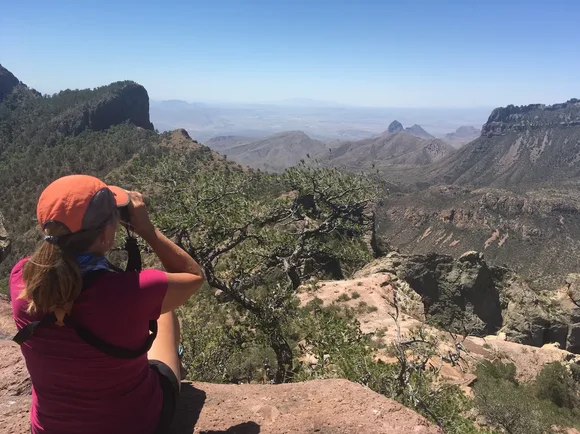
The Rio Grande carved three major canyons through limestone on its way to the Gulf, and Big Bend protects the wildest stretch. Santa Elena Canyon rises 1,500 feet straight up from the river, narrow enough that you lose sunlight by mid-afternoon. The Chisos Mountains interrupt the desert floor like a geological mistake, holding bear and mountain lion populations that most Texas parks gave up decades ago. You'll find more bird species here than any other park in the system, over 450 recorded, because Big Bend sits at the confluence of multiple flyways and climate zones.
Big Bend measures distance in hours, not miles, and cell service in days, not bars.
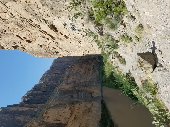
April brings wildflowers to the desert floor and comfortable hiking temperatures before the summer heat locks down the lowlands. The Window Trail drops through oak woodland to a natural pour-off with views across the Chihuahuan Desert, while Lost Mine Trail climbs to ridge views of the entire Chisos Basin. Most visitors never make it past the scenic drive, which means the backcountry stays genuinely empty. You can camp in the Chisos Basin or down at Rio Grande Village, but book months ahead for April.
Carlsbad Caverns National Park
600 feet underground / Carved by acid, not water / 400,000 bats at dusk
Most caves form when water dissolves limestone over millennia. Carlsbad formed when hydrogen sulfide from oil deposits mixed with oxygen in groundwater, creating sulfuric acid that ate through the reef. The result looks less like a typical cave and more like a cathedral designed by someone on hallucinogens. The Big Room stretches nearly four football fields long with ceilings that disappear into darkness. You descend through the Natural Entrance on a paved trail that switchbacks into the earth, passing formations that took six million years to grow.
The temperature stays at 56 degrees year-round, which means you'll need a jacket in April while the surface bakes at 80.
The bat flight happens at sunset from late May through October, when Mexican free-tailed bats spiral out of the cave mouth in a tornado of wings. April misses the bats, but you gain elbow room underground. The crowds that pack the Big Room in summer thin to manageable numbers, and you can actually hear the silence that makes caves feel otherworldly. The King's Palace Tour requires a ranger escort and takes you into formations the self-guided route skips. No camping in the park, but Whites City sits 20 minutes away with motels that haven't updated since 1960.
Grand Canyon National Park
One mile deep, 277 miles long / More trail miles than most states have highways / April dodges peak season
The Colorado River spent six million years cutting through rock layers that span two billion years of Earth's history. The scale defeats photography and humbles ego. South Rim stays open year-round and holds the infrastructure, which means it also holds the crowds. North Rim opens in mid-May, sits 1,000 feet higher, and sees a fraction of the traffic. April lands in that shoulder season when the South Rim thaws out but the summer hordes haven't arrived yet.
You can see the Grand Canyon from the rim in 20 minutes or spend a lifetime hiking it and never see the same thing twice.
The Rim Trail covers nearly 13 miles along the South Rim, mostly paved, accessible to wheelchairs and strollers at many points. Bright Angel Trail and South Kaibab Trail both descend into the canyon proper, but don't attempt to reach the river and return in one day unless you're training for an ultramarathon. Most hikers turn around at the 1.5-mile rest house or the three-mile rest house, which still delivers the canyon's geological lesson without the life-threatening commitment. April temperatures range from the 50s at the rim to the 80s at the river, comfortable enough for serious hiking if you start before dawn.
Guadalupe Mountains National Park
Texas's highest peak / Ancient fossil reef / Draws fewer people than a small college town
Guadalupe Peak rises to 8,751 feet from the Chihuahuan Desert floor, the remnant of a 265-million-year-old reef that formed when this part of Texas sat underwater. The rock holds fossilized sponges, algae, and marine life from the Permian period, visible in roadcuts and trail exposures. McKittrick Canyon turns into one of the Southwest's best fall color shows when the maples and oaks ignite in October, but April brings wildflowers and temperatures that make the summit hike survivable.
Guadalupe Peak Trail gains 3,000 feet in four miles, and there's no shade once you leave the canyon bottom.
Most people have never heard of Guadalupe Mountains, which keeps the trails empty even on weekends. Devil's Hall Trail follows a drainage through limestone narrows to a natural staircase, moderate terrain with slot canyon scenery. Salt Basin Dunes sit on the western edge of the park, a small dunefield accessible by high-clearance vehicle or a long hike from the highway. The park offers no services beyond pit toilets and campgrounds. Bring everything you need from El Paso or Carlsbad, and plan for wind that can hit 50 mph without warning.
Petrified Forest National Park
225-million-year-old trees turned to quartz / Painted Desert badlands / 28 miles of scenic drive
The trees that became stone fell during the Triassic period, when this part of Arizona held forests instead of desert. Volcanic ash buried the logs, and silica-rich groundwater replaced the wood cell by cell with quartz. The result looks like lumber yards scattered across technicolor badlands, with logs split to reveal crystals and cross-sections that show growth rings from before dinosaurs. Blue Mesa drops into bentonite clay hills that erode into hoodoos and ridges in shades that don't look real.
Petrified Forest rewards people who get out of the car, but you can see the highlights in half a day if you're racing between Grand Canyon and points east.
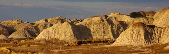
The Painted Desert Rim Trail follows the northern edge of the park where badlands stretch to the horizon in layers of purple, red, and white. Crystal Forest and Giant Logs sit on the southern end, short walks through concentrations of petrified wood that include specimens wider than car hoods. April brings mild temperatures and occasional wildflowers, though the desert bloom here never matches Big Bend or Death Valley. No camping in the park, but Holbrook sits 25 miles west with motels and gas stations.
Saguaro National Park
Split across Tucson / Densest saguaro stands anywhere / Peak season crowds in April
Saguaro grows only in the Sonoran Desert, and the densest forests surround Tucson. The park splits into two districts: Rincon Mountain District to the east and Tucson Mountain District to the west. Saguaros take 75 years to grow their first arm and can live 200 years, reaching 40 feet tall and weighing eight tons. The iconic silhouettes you picture when someone says Arizona all grow here, framed by mountains and punctuated by ocotillo, cholla, and prickly pear.
April brings wildflower blooms and temperatures in the 70s, but it also brings crowds that pack the parking lots by mid-morning.
Valley View Overlook Trail in the west district climbs to ridge views over a saguaro forest that stretches to the horizon. Cactus Forest Trail in the east district loops through dense stands on easy terrain suitable for families. The Desert Discovery Trail includes interpretive signs explaining Sonoran ecology, short enough for kids but detailed enough to teach adults something new. Both districts sit close enough to Tucson that you can base in the city and drive to trailheads in 30 minutes, but the proximity also means weekend crowds.
White Sands National Park
World's largest gypsum dunefield / 275 square miles of white sand / Dunes shift 30 feet per year
Gypsum usually dissolves in water, which makes White Sands a geological oddity. The Tularosa Basin has no outlet to the sea, so when Lake Lucero dries each year, gypsum crystals get picked up by wind and deposited into dunes. The sand stays cool underfoot even in summer because gypsum reflects rather than absorbs heat. The dunes swallow entire ecosystems, burying plants and forcing species to adapt or retreat. Kids sled down the slopes on plastic discs while photographers chase the contrast between white sand and blue sky.
White Sands looks like winter in the desert, a snowfield that never melts and never loses its brightness.
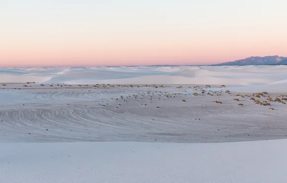
Dune Drive loops eight miles through the heart of the dunefield, with pullouts and short trails at intervals. Alkali Flat Trail covers five miles through the most remote section of dunes, where you navigate by posts because landmarks disappear behind shifting sand. The Interdune Boardwalk explains the specialized plants and animals that survive here, including bleached versions of species that evolved lighter coloring to blend with the gypsum. April brings warm days and cool nights, comfortable for hiking before the summer heat makes midday exploration unpleasant. The park sits adjacent to White Sands Missile Range, which occasionally closes the road for tests. Check the schedule before you drive two hours from El Paso.