The Utah National Parks Road Trip
Five parks where iconic drives meet serious trails, all within a 600-mile loop through Utah's high desert sandstone
Utah packs five national parks into a corridor smaller than West Virginia, each built on the same high desert foundation of sandstone and solitude. What sets this road trip apart is the combination of terrain you can drive through on pavement and terrain you'll need your legs for. Every park on this loop balances iconic scenic drives with trails that drop you deep into slot canyons, hoodoo forests, and fin formations where the real work begins.
April turns this circuit from punishing to practical. Summer heat makes midday hiking dangerous across all five parks, but April keeps daytime highs in the 70s and 80s while the crowds remain just below peak season density. You'll still share Delicate Arch with dozens of other hikers, but you won't wait in traffic to enter the parks at dawn.
Zion National Park
Canyon walls rise 2,000 feet above the Virgin River / Draws more people than any park except Yellowstone and the Smokies
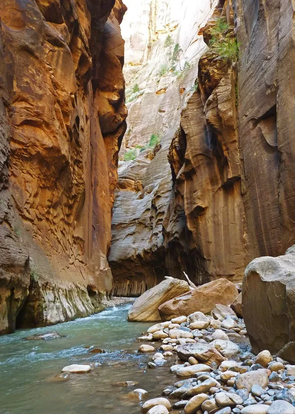
Zion gives you the scenic drive first, whether you want it or not. Private vehicles can't enter Zion Canyon from March through November, so you'll ride the shuttle to every trailhead. The system works because the canyon itself is the draw: sheer Navajo sandstone walls that glow orange at sunrise and cast shadows so deep the river stays cold in July. Angels Landing and The Narrows anchor the experience, but they also concentrate the crowds. Angels Landing requires a permit now, and The Narrows funnels hundreds of people through waist-deep water on busy weekends.
You'll touch both canyon walls in The Narrows while looking up at a ribbon of sky a thousand feet above you.
The Pa'rus Trail runs paved and flat along the Virgin River, accessible to strollers and wheelchairs, while Canyon Overlook Trail delivers expansive views with minimal elevation gain. Both offer entry points for families who want the canyon experience without the endurance test. The shuttle makes park navigation simple for kids: every stop is numbered, and you can hop on and off as energy levels dictate.
Bryce Canyon National Park
Earth's densest concentration of hoodoos / Sits at 8,000 feet where the air thins and the views stretch
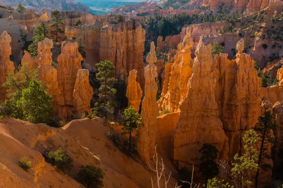
Bryce delivers its signature landscape within 50 feet of the parking lot. You can stand at Sunrise Point or Sunset Point and see the entire amphitheater of orange spires without walking a single trail. The rim road connects a dozen overlooks over 18 miles, each offering a different angle on the same geologic spectacle. But Bryce rewards the descent. The Navajo Loop drops you below the rim into a forest of hoodoos so tightly packed you'll navigate by slot canyon logic, turning sideways through gaps like Wall Street where the rock face closes in from both sides.
Driving Bryce gives you the postcard; hiking it puts you inside the geology textbook.
Queen's Garden Trail offers the easiest route into the hoodoo maze with moderate grades and well-maintained switchbacks. Combine it with Navajo Loop for a circuit that shows you both the whimsical formations near the top and the narrow corridors near the canyon floor. The elevation keeps April temperatures cooler than the lower desert parks, but it also means afternoon thunderstorms build fast. Rangers run programs at the visitor center and the Lodge amphitheater, giving kids structured activities between trail sections.
Capitol Reef National Park
A hundred-mile fold in the earth's crust / Fruita orchards still produce fruit you can pick
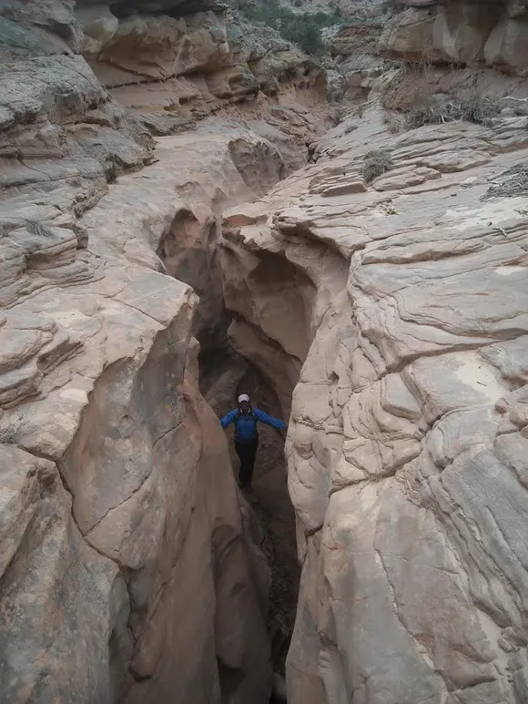
Capitol Reef sits in the middle of Utah's park circuit but off the mental map for most visitors, which means it absorbs crowds differently than Zion or Arches. The scenic drive through the park runs 25 miles round trip on pavement, passing Capitol Dome, the Fruita Historic District, and access points to slot canyons like Grand Wash. The Waterpocket Fold stretches for 100 miles north to south, a massive monocline that tilts layers of sandstone at angles that create natural water pockets and hidden canyons.
You can hike through a canyon in the morning and pick apricots from century-old trees in the afternoon.
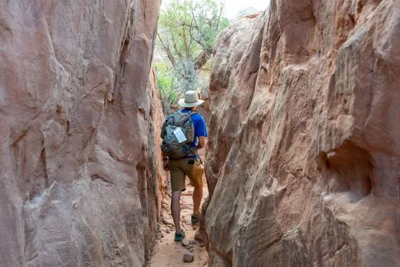
Grand Wash Trail follows a canyon floor between vertical walls for over two miles, flat enough for kids to manage without technical skills. Hickman Bridge Trail climbs to a natural arch with views across the Waterpocket Fold, moderate effort for a clear payoff. The Fruita orchards become a destination themselves: the Park Service maintains the trees planted by Mormon settlers, and you're allowed to eat fruit while you're in the orchard or take it with you for a small fee. April means blossoms instead of fruit, but the trees still frame the red cliffs behind them.
Arches National Park
More than 2,000 natural stone arches / Packed from sunrise to sunset in peak season
Arches makes you work for its most famous feature. Delicate Arch sits three miles round trip from the trailhead, most of it across exposed slickrock with no shade and a final scramble along a narrow ledge. The payoff is the arch you've seen in every Utah tourism photo, standing alone on a sandstone bowl with the La Sal Mountains behind it. The scenic drive through the park covers 18 miles one way, passing Balanced Rock, the Windows Section, and Devils Garden, where you can see a dozen arches from the parking area or hike seven miles to reach Landscape Arch, one of the longest natural spans in the world.
You'll share Delicate Arch with 30 other people at sunset, but the moment it glows orange makes you forget the crowd.
The Windows Loop gives families an easy introduction to arch formation with minimal elevation gain, while Sand Dune Arch hides in a narrow corridor where kids can play in the sand that collects beneath the span. Fiery Furnace requires a permit and a ranger-guided tour, threading through fin formations so tight you'll navigate by feel. Park Avenue Trail drops into a canyon lined with sandstone towers, an easy two-mile walk if you arrange a shuttle between trailheads. April mornings start cool enough for the Delicate Arch hike, but by afternoon the exposed rock radiates heat.
Canyonlands National Park
Four districts larger than many national parks combined / Draws fewer visitors than its neighbors despite the size
Canyonlands divides into separate worlds that require separate trips. Island in the Sky sits closest to Moab and delivers the classic overlook experience: drive to the end of the road at Grand View Point and stare across canyons that stretch to the horizon. The Needles district trades overlooks for trail access into striped sandstone formations and backcountry campsites. The Maze remains truly remote, requiring four-wheel drive and backcountry skills. Most visitors never leave Island in the Sky, which means you can find solitude in The Needles even during busy weekends.
The overlooks give you scale, but the trails give you the geology up close where you can touch the layers.
Mesa Arch frames the sunrise over canyons carved by the Colorado and Green Rivers, a short walk from the parking lot that attracts photographers by the dozen. Upheaval Dome offers a moderate hike to a mysterious crater formation that looks more like meteor impact than erosion. The White Rim Road loops 100 miles through the canyons below Island in the Sky, accessible only by mountain bike or four-wheel drive, requiring permits and overnight camping. For families, the short trails near the visitor center provide accessible viewpoints while longer routes like Chesler Park in The Needles offer full-day adventures through slot canyons and meadows ringed by sandstone spires.