10 Most Demanding Trails in the National Parks
The national park trails that test your conditioning, patience, and ability to keep moving when your legs start negotiating for rest breaks
The national parks don't grade on a curve. Some trails hand you scenery on a gentle grade, while others make you earn every vista with sustained climbing, unforgiving exposure, or distances that stretch your daylight window. This ranking isn't about technical rock scrambles or Class 3 routes that require a helmet — it's about the trails that test your conditioning, patience, and ability to keep moving when your legs start negotiating for rest breaks.
What separates a demanding trail from a merely long one comes down to how the pieces stack together. Elevation gain matters, but so does how quickly it arrives. Distance wears you down differently than sustained grade. And remoteness changes everything when your turnaround time depends on making it back before dark.
Mount Jackson, Glacier National Park
A 400-story climb to Glacier's sixth-highest peak / Scramble the final pitch to the summit
Mount Jackson doesn't ease you into anything. From the Gunsight Pass trailhead, you'll follow the valley floor past wildflower meadows and through stands of subalpine fir before the trail turns upward with a vengeance. Four thousand feet of elevation gain stacks up like climbing a 400-story building, and the pitch rarely relents. The lower miles offer stretches of forest where you can settle into a rhythm, but once you break treeline, the route becomes a choose-your-own-adventure scramble over talus and exposed ridgeline.

The summit delivers the kind of 360-degree mountain panorama that justifies every grunt on the way up — glaciers, knife-edge arêtes, and alpine lakes scattered below like pieces of broken mirror.
This isn't a trail for your first week back from a desk job. The scramble to the summit requires steady hands and comfort with exposure, and weather can turn fast once you're above treeline. Most people who bag this peak have already logged serious vertical in the park and know what four thousand feet of climbing feels like in their quads. The turnaround time matters here — afternoon thunderstorms are common, and you don't want to be picking your way down wet rock in a lightning storm.
Gunsight Pass to Jackson Glacier, Glacier National Park
A full-day alpine march into Glacier's remote heart / Permit required for this backcountry classic
This is one of Glacier's great epics — a trail that demands a full day and rewards you with some of the most dramatic alpine scenery in the Lower 48. You'll start from the Jackson Glacier Overlook trailhead and drop into the Saint Mary Valley before the real work begins: a relentless climb through subalpine meadows and increasingly thin air toward Gunsight Pass. The elevation gain alone would make this strenuous, but fifteen miles of distance turns it into an endurance test that separates hikers who train from those who just hope their legs hold out.
At the pass, the views crack open in every direction — glaciers clinging to north-facing cirques, valleys plunging away on both sides, and the kind of silence that only comes from being this far from a road.
The trail feels genuinely remote once you're past the first few miles, and that remoteness matters when you're calculating turnaround times. You'll need to move efficiently to make it back before dark, and the descent tests knees that are already tired from the climb. Most people who attempt this trail have already logged serious miles in the park and know how to pace themselves for a ten-hour day. The permit requirement keeps crowds manageable, but don't mistake solitude for ease — this trail will find your weak spots and press on them.
Belly River Trail to Poia Lake, Glacier National Park
Nearly thirteen miles into grizzly country / Glacier's quiet side, permit required
This is Glacier's quiet side — the kind of trail where you might see more grizzlies than people, and that's not an exaggeration. Starting from the Belly River trailhead near the Chief Mountain border crossing, you'll drop into a broad, glacier-carved valley that feels genuinely remote within the first mile. The trail rolls through forest and meadow with moderate elevation gain, but what makes this demanding is the distance and the fact that you're deep in bear country the entire time. Thirteen miles round-trip means you'll be moving for six to eight hours, and every moment requires the kind of awareness that comes from knowing you're a guest in someone else's home.
Poia Lake sits in a cirque ringed by peaks, its water the impossible turquoise that only comes from glacial flour, and the silence feels absolute except for the occasional rockfall echoing off the headwall.
The remoteness is the point here. Most visitors to Glacier never make it to the Belly River drainage, and that seclusion is part of what makes this trail rewarding. But remoteness also means you're on your own timeline with limited bailout options if weather turns or someone twists an ankle. The permit requirement keeps numbers low, and rangers aren't subtle about emphasizing bear safety protocols. If you're not comfortable making noise, carrying bear spray within easy reach, and staying alert for hours at a time, save this one for when you've logged more miles in grizzly country.
Grinnell Glacier Trail, Glacier National Park
Ten miles to a receding ice field / The trail that hooks first-time visitors
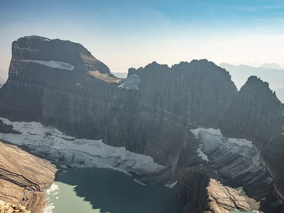
This is the trail that makes people fall in love with Montana. You'll start from the Many Glacier area and spend the first couple miles winding along the shores of Swiftcurrent Lake and Lake Josephine — flat, easy, and deceptively pleasant. Then the real work begins. The trail climbs steadily up a series of switchbacks carved into the mountainside, gaining 1,560 feet with increasing exposure and increasingly thin air. What started as a lakeside stroll becomes a lung-testing climb where you'll stop more often than you planned, ostensibly to take photos but really to let your heart rate settle.
The glacier itself clings to a north-facing cirque like the last holdout from an ice age, its edges retreating visibly year by year — a moving lesson in climate change that no documentary can match.
The scenery justifies the effort, which is why this trail draws crowds that can turn the parking lot into a competitive sport by midmorning. Most hikers take six to seven hours round-trip, and the descent is harder on knees than you'd expect given the moderate grade. Late July hits the sweet spot when the trail is fully snow-free and wildflowers carpet the meadows below the glacier. If you're visiting Glacier for the first time, this trail belongs on your shortlist — just don't underestimate how much that elevation gain adds up when you're already starting at altitude.
Apgar Lookout, Glacier National Park
Nearly 2,000 feet up in less than four miles / A relentless grade through dense forest
This trail wastes no time with pleasantries. From the trailhead just north of Glacier's West Entrance, you're climbing immediately through dense forest on a relentless grade that gains nearly 2,000 feet over just 3.6 miles. Do the math and your quads will confirm it's steep the entire way. The lower section tunnels through lodgepole pine and Douglas fir, offering zero views and maximum sweat, while the upper section breaks into patches of subalpine meadow where you can finally see what you're climbing toward.
The fire lookout at the summit commands views across Lake McDonald, the Livingston Range, and enough peaks to keep you rotating in place trying to identify them all — the kind of payoff that makes the grind worthwhile.
What makes this trail demanding isn't technical difficulty — it's a straightforward climb on a well-maintained path. It's the sustained grade that never relents and the forest that traps heat on summer afternoons. Most people who tackle this trail are experienced hikers looking for a conditioning workout or summit baggers checking off another fire lookout. The solitude is a bonus — this trail sees a fraction of the traffic that the Going-to-the-Sun Road trails get, and you might have the lookout to yourself if you time it right. Start early to beat both the heat and the afternoon thunderstorms that roll through the mountains with little warning.
Iceberg Lake, Glacier National Park
Nearly ten miles through wildflower meadows to a cirque filled with floating ice / Mountain goats included
Starting from the Iceberg/Ptarmigan trailhead near Swiftcurrent Motor Inn, you'll climb gradually through dense subalpine forest before the trees thin out and the valley opens up in a way that makes you stop mid-stride. The trail winds through wildflower meadows that peak in late July, with Ptarmigan Falls providing a mid-hike photo stop before the final push into the cirque. The elevation gain is moderate compared to some of Glacier's other trails, but ten miles round-trip adds up when you're moving at altitude and stopping every few minutes to photograph bear grass and Indian paintbrush.
The lake sits in a natural amphitheater with walls rising nearly vertical on three sides, and even in late summer, chunks of ice the size of cars float in water so cold it makes your teeth hurt just looking at it.
This trail delivers scenery that justifies the effort, which is why it's one of Glacier's most popular hikes. The moderate rating doesn't mean easy — five to six hours of hiking requires decent conditioning and enough snacks to keep your energy up. Mountain goats treat the area like their personal living room, often lounging on rocks near the lake's outlet with the kind of indifference that suggests they've seen plenty of hikers before you. The best time to go is late July when wildflowers peak and icebergs are still abundant, but expect company. This isn't a solitude hike unless you start at dawn.
Avalanche Lake, Glacier National Park
A short climb through old-growth forest to a waterfall-rimmed lake / Glacier's most rewarding easy hike
This is one of the most rewarding short hikes in Glacier — a 2.3-mile walk through old-growth cedar and hemlock forest that feels like stepping into the Pacific Northwest's cathedral. The trail follows Avalanche Creek through a moss-draped gorge before climbing a gentle but steady grade to the lake. Five hundred feet of elevation gain arrives gradually enough that you barely notice until you're catching your breath and realizing you've been climbing the whole time.
The lake sits in a glacial cirque with waterfalls cascading down the headwall in ribbons of white, and the pebble beach at the outlet offers front-row seats to one of Glacier's most photogenic scenes.
The moderate rating is accurate for people with basic fitness, but don't mistake short for trivial. The crowds can be shoulder-to-shoulder in peak season, and the parking lot fills by midmorning. Most families with kids who can handle a few miles tackle this trail, and it's a smart choice for a first day in the park when you're still adjusting to altitude. The forest canopy provides shade for most of the route, making this a good option when other trails are baking in afternoon sun. Early morning offers the best light hitting the headwall waterfalls and the slimmest chance of finding a parking spot without circling like a vulture.
Hidden Lake Overlook, Glacier National Park
Three miles from Logan Pass to an alpine overlook / Mountain goats treat this trail like a highway
Starting from the Logan Pass visitor center — already one of the most spectacular trailheads in the country — you'll climb a well-maintained boardwalk through alpine meadow before the path turns to packed dirt and loose rock. The elevation gain is steady but never cruel, more of a persistent nudge than a lung-burner. The wildflowers peak in late July, turning the meadows into a riot of color that makes you understand why this trail shows up in every Glacier highlight reel.
The overlook delivers views across Hidden Lake to peaks stacked in every direction, with mountain goats often posing on nearby outcrops like they know exactly what you came here to photograph.
The moderate rating is spot-on for anyone with basic conditioning, but the altitude matters — Logan Pass sits at 6,646 feet, and even a short climb at that elevation makes your lungs work harder than they would at sea level. This is one of Glacier's most popular hikes, which means crowds that can turn the boardwalk into a conga line by midmorning. The parking lot at Logan Pass is famously competitive, and finding a spot after 8 AM requires patience and luck. If you can time it for early morning or late afternoon, you'll trade some of the crowds for better light and more chances to see wildlife without someone's phone in your peripheral vision.
Apgar Bike Path, Glacier National Park
A paved mile and a half through lodgepole forest / Glacier's most mellow outing
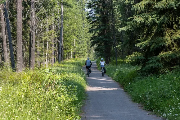
This is Glacier's most mellow outing — a paved path that rolls south from the Apgar area through a corridor of lodgepole pine and western larch, with occasional glimpses of Lake McDonald's impossibly blue water filtering through the trees. The asphalt surface is smooth and mostly flat, making this accessible for strollers, wheelchairs, and anyone looking for a walk that doesn't require trail shoes or elevation gain. It's the kind of path you tackle on arrival day when your legs are still stiff from the drive and you're not ready for anything that requires sustained effort.
This isn't a trail that will test you or deliver summit views, but it offers an easy way to stretch your legs and remind yourself why you drove all this way to Montana.
The path sees steady use from families, cyclists, and people recovering from harder hikes earlier in the trip. Late June through September offers the most reliable conditions, and early evening delivers soft light through the forest canopy. This isn't a destination hike — it's a palate cleanser between bigger efforts, a way to get outside without committing to hours of climbing, or a backup plan when weather shuts down higher elevation trails. Sometimes the best hike is the one that doesn't hurt.
Fish Creek Bike Path, Glacier National Park
Just over a mile along Lower McDonald Creek / Barely enough elevation to register
This is about as mellow as Glacier gets — a paved bike path that follows the edge of Lower McDonald Creek, winding through cedar and hemlock forest with the kind of dappled light that makes everything look like a screensaver. Starting near the Camas Road bridge, the path rolls along with barely enough elevation gain to register on any device. Twenty-five feet of climbing over a mile means you'll never break a sweat unless the temperature is truly oppressive.
The creek provides a constant soundtrack of moving water, and the forest canopy keeps things cool even when the parking lot is baking in afternoon sun.
This path serves the same purpose as the Apgar Bike Path — a low-commitment outing for families, rest day recovery, or anyone who wants to move without earning it. Cyclists use it to connect different parts of the park's west side, and runners looking for easy miles appreciate the smooth surface. Late June through September offers the best conditions, with mornings delivering the best light through the forest canopy. This isn't a trail you'll brag about completing, but it's honest about what it offers: a pleasant walk along a creek without any pretense of being more than that.