10 National Park Trails With the Most Elevation Gain
Glacier's steepest climbs ranked by vertical feet, from lung-burners to summit scrambles that earn every inch of elevation
Elevation gain is the great equalizer. A trail can be short and brutal or long and relentless, but the number of vertical feet you climb tells you more about what you're in for than distance ever will. These ten trails in Glacier National Park represent the full spectrum of vertical challenges, from modest climbs that reward beginners to lung-burning ascents that test experienced hikers. Some stack their elevation into steep, punishing grades. Others spread it across miles of steady climbing. All of them will remind you that gravity is undefeated.
What matters here isn't just the total gain but how the trail delivers it. A thousand feet over two miles feels very different from a thousand feet over five. These rankings reflect the raw vertical numbers, but the narratives will tell you what those numbers actually feel like on your legs.
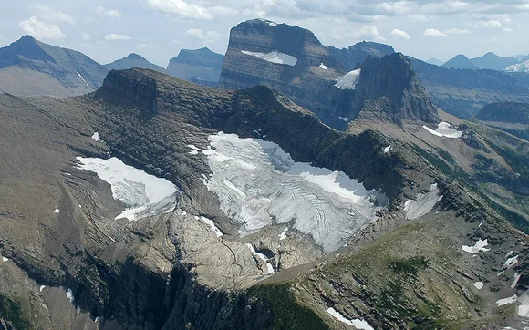
Mount Jackson, Glacier National Park
Nearly 4,000 feet of climbing that stacks up like a 400-story building / Summit scramblers only
Mount Jackson doesn't ease you into anything. From the Gunsight Pass trailhead, you'll follow the valley floor past wildflower meadows and through stands of subalpine fir before the trail turns upward with a vengeance. The elevation gain stacks up relentlessly, and by the time you reach the ridge, your legs will have confirmed what the map already told you: this is one of the most vertical days you can have in Glacier without technical climbing gear.

The upper route requires scrambling over loose rock and exposed ledges, where every step demands attention and the views demand you stop to catch your breath anyway.
This isn't a trail for first-timers or casual peak baggers. The final push to the summit involves Class 3 scrambling, and the route-finding gets sketchy when clouds roll in. But if you're collecting summits in Glacier, Mount Jackson offers the kind of bragging rights that come with genuine suffering. Most people you pass on the way up will have the same glazed look of determination, and the summit register proves this is a badge-of-honor kind of day.
Gunsight Pass to Jackson Glacier, Glacier National Park
15 miles through alpine drama with 2,200 feet of climbing / One of Glacier's great epics
This is one of Glacier's great epics, a full-day march through some of the most dramatic alpine scenery in the Lower 48. You'll start from the Jackson Glacier Overlook trailhead and drop into the Saint Mary Valley before the real work begins: a relentless climb through subalpine meadows and increasingly thin air. The pass itself sits high enough that snow lingers well into summer, and the views from the saddle stretch across a landscape of knife-edge ridges and hanging glaciers.
The climb to Gunsight Pass is the kind of sustained uphill that makes you question your fitness, your gear choices, and whether you packed enough snacks.
This trail requires a permit, which keeps the crowds manageable but also means you need to plan ahead. Most hikers camp at the backcountry sites near the pass and spread the elevation gain over two days, but strong day hikers with an early start can complete the round trip in a long, punishing push. Either way, you'll earn every foot of elevation and every photo you take at the pass.
Apgar Lookout, Glacier National Park
Nearly 2,000 feet in less than four miles / Steep the entire way
This trail wastes no time with pleasantries. From the trailhead just north of Glacier's West Entrance, you're climbing immediately through dense forest on a relentless grade. The math is simple and unforgiving: 1,850 feet over 3.6 miles means your quads will be screaming before you reach the halfway point. The lower forest offers some shade but little in the way of views, so the climb feels like an investment you won't cash in until the top.
The fire lookout at the summit offers 360-degree views over Lake McDonald, the Livingston Range, and the kind of silence that makes the climb worth every switchback.
This is one of Glacier's less-traveled trails, partly because the grade is punishing and partly because it doesn't lead to a glacial lake or dramatic cirque. But if you're looking for solitude and a workout that doubles as penance, Apgar Lookout delivers. The descent is almost as hard as the climb, steep enough that your toes will jam into the front of your boots and your knees will remind you about it the next morning.
Grinnell Glacier Trail, Glacier National Park
10.6 miles to one of the park's most photogenic glaciers / 1,560 feet of steady climbing
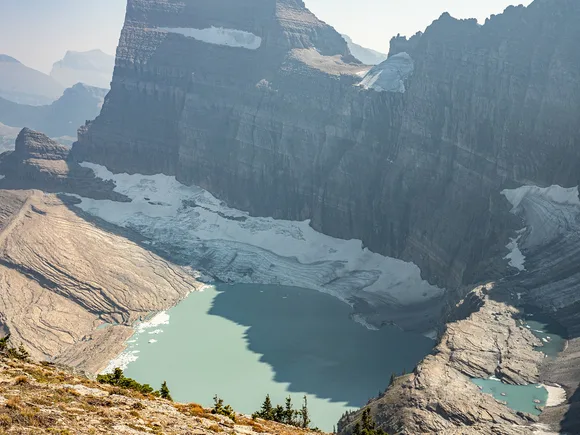
This is the trail that makes people fall in love with Montana. You'll start from the Many Glacier area and spend the first couple miles winding along the shores of Swiftcurrent Lake and Lake Josephine — flat, easy, and deceptively pleasant. Then the real work begins. The trail climbs steadily up a series of switchbacks carved into the cliffside, with views that get better with every turn and legs that get heavier with every step.
By the time you reach Upper Grinnell Lake, the glacier spreads across the headwall like a postcard that doesn't need a filter.
The elevation gain is manageable for most hikers, but the exposure on the upper switchbacks can rattle anyone with a fear of heights. The trail hugs the cliffside with a sheer drop to the lake below, and while the path is wide and well-maintained, it's not the place to let your mind wander. Late July offers the best conditions, when wildflowers blanket the lower meadows and the glacier still holds enough ice to feel like you've reached something worth the climb.
Belly River Trail to Poia Lake, Glacier National Park
12.8 miles into Glacier's quietest corner / 1,400 feet of climbing through grizzly country
This is Glacier's quiet side, the kind of trail where you might see more grizzlies than people, and that's not an exaggeration. Starting from the Belly River trailhead near the Chief Mountain border crossing, you'll drop into a broad, glacier-carved valley that feels genuinely remote within the first mile. The elevation gain is spread across the entire distance, making for a steady but never brutal climb that rewards patience more than brute strength.
Poia Lake sits in a cirque so isolated that reaching it feels like discovering something most people will never see.
This trail requires a permit, which keeps the foot traffic low and the wildlife encounters high. You'll need to be vigilant about bear safety — this is core grizzly habitat, and sightings are common enough that making noise and carrying bear spray aren't suggestions, they're requirements. The lake itself is worth the effort, but the real reward is the sense of solitude that's increasingly rare in Glacier's more famous corners.
Iceberg Lake, Glacier National Park
Nearly 10 miles to a lake filled with floating ice / 1,000 feet of gradual climbing
Starting from the Iceberg-Ptarmigan trailhead near Swiftcurrent Motor Inn, you'll climb gradually through dense subalpine forest before the trees thin out and the valley opens up in a way that makes you stop mid-stride. The trail winds through wildflower meadows that peak in late July, with Ptarmigan Falls providing a midpoint distraction before the final push to the lake. The elevation gain is gentle enough that families with strong kids can manage it, but the distance still demands respect.
Iceberg Lake sits in a massive cirque with walls that rise hundreds of feet on three sides, and even in August, chunks of ice the size of cars float in water so cold it hurts to touch.
This is one of Glacier's most popular trails, and for good reason. The scenery delivers on every promise the trailhead sign makes, and the lake itself feels like a reward engineered specifically for hikers willing to put in the miles. Bring layers — the cirque traps cold air, and temperatures at the lake can be 20 degrees cooler than at the trailhead. The climb back out feels longer than the climb in, but the gradient is forgiving enough that even tired legs can handle it.
Hidden Lake Overlook, Glacier National Park
3 miles from Logan Pass to an alpine overlook / 680 feet of climbing through bighorn sheep territory
Starting from the Logan Pass visitor center — already one of the most spectacular trailheads in the country — you'll climb a well-maintained boardwalk through alpine meadow before the path turns to packed dirt and loose rock. The elevation gain is steady but never cruel, more of a persistent nudge than a punishment. Bighorn sheep treat the area like a suburban lawn, often grazing within a few feet of the trail and barely glancing up as hikers pass.
The overlook sits on a rocky outcrop above Hidden Lake, with views that stretch across the Continental Divide and make the short climb feel like the best trade you've made all trip.
This is one of Glacier's most accessible alpine experiences, short enough for families and spectacular enough for photographers who've seen it all. The trail gets crowded, especially in the midday window when Going-to-the-Sun Road traffic peaks, but early morning starts offer relative solitude and better light. The boardwalk section can be icy well into July, so watch your footing even when the rest of the trail is dry.
Avalanche Lake, Glacier National Park
4.6 miles round trip through old-growth forest / 500 feet of climbing to a waterfall-ringed lake
This is one of the most rewarding short hikes in Glacier, a walk through old-growth cedar and hemlock forest that feels like stepping into the Pacific Northwest's cathedral. The trail follows Avalanche Creek through a moss-draped gorge before climbing a gentle but steady grade. The elevation gain is modest, spread across enough distance that even casual hikers can handle it without much suffering.
Avalanche Lake sits in a dramatic amphitheater with waterfalls spilling down the headwall in a display that peaks in early summer when snowmelt is at its heaviest.
The trail is popular for good reason — it delivers alpine drama without requiring technical skills or all-day commitment. The lake itself is cold enough to make swimming a brief, gasping affair, but plenty of hikers wade in anyway. The forest provides shade for most of the approach, making this a solid choice on hot days when exposed alpine trails feel like punishment.
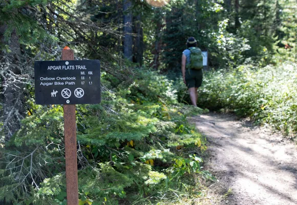
Fish Creek Bike Path, Glacier National Park
Barely over a mile of paved path / 25 feet of elevation gain, if you can even call it that
This is about as mellow as Glacier gets, a paved bike path that follows the edge of Lower McDonald Creek, winding through cedar and hemlock forest with the kind of dappled light that makes everything look like a screensaver. Starting near the Camas Road bridge, the path rolls along with barely enough elevation change to register on anything but the most sensitive altimeter. This isn't a trail you hike for the challenge — it's the trail you take when your legs are still recovering from yesterday's summit push and you need to move without suffering.
The creek burbles along beside the path, and the only effort required is deciding whether to walk or rent a bike from the nearby lodge.
This path is accessible in the truest sense — paved, flat, and wide enough for wheelchairs and strollers. It's perfect for arrival day when you want to stretch your legs without committing to a real hike, or for families with young kids who need something manageable. The forest canopy provides shade, and the creek provides a soundtrack that makes the short distance feel more meditative than it has any right to be.
Apgar Bike Path, Glacier National Park
1.5 miles of flat, paved path / Zero elevation gain, zero excuses
This is Glacier's most mellow outing, a paved path that rolls south from the Apgar area through a corridor of lodgepole pine and western larch, with occasional glimpses of Lake McDonald's impossibly blue water filtering through the trees. The asphalt surface is smooth and mostly flat, making it feel more like a neighborhood greenway than a national park trail. There's no elevation gain to speak of, which means this is the trail you take when you need to move your legs without actually working them.
The path is so flat and easy that it feels almost apologetic, like Glacier is admitting that not every outing needs to involve switchbacks and bear spray.
This is perfect for cyclists, families with toddlers, or anyone who just wants to be outside without the pressure of a real hike. The path is wide enough for strollers and wheelchairs, and the gentle grade makes it accessible for visitors with mobility challenges. It's not dramatic, it's not Instagram-worthy, and it won't test your fitness. But sometimes that's exactly the point.